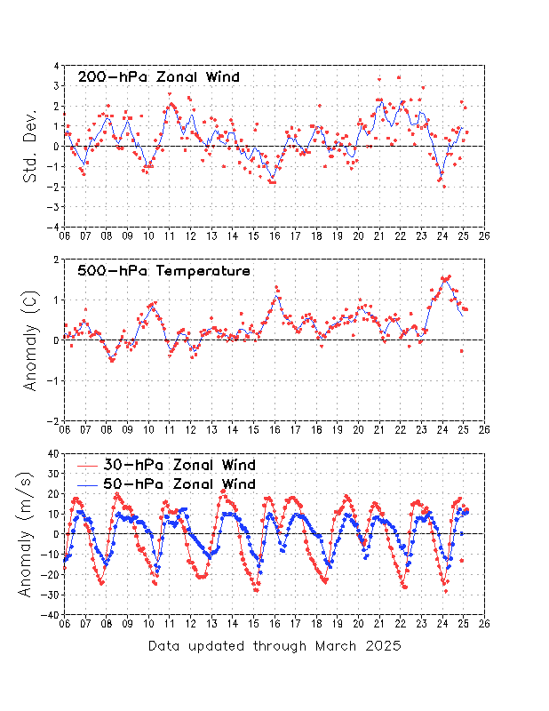
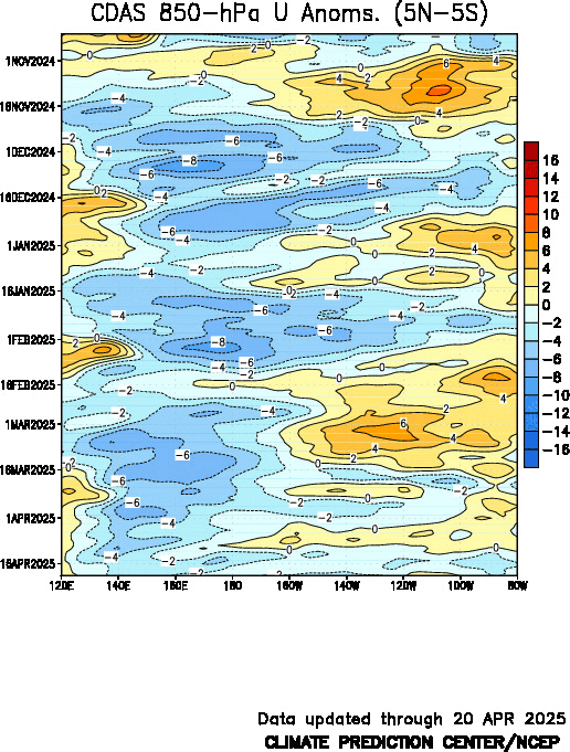
4 out of the last 5 years with tornado counts being more than 1 standard deviation above normal have been during or immediately following a transition from El Nino to La Nina (1998, 1999, 2008, 2011):


 On December 31st, it produced widespread blizzard conditions in the Northern Plains and tornadoes in Missouri and Arkansas which killed 7 people. Water vapor image during the outbreak:
 On January 1st, Tucson had a low temperature of 21, beating the old record of 22 set in 1919. Kitt Peak had a low of -3, breaking the all-time record of 2 set on January 31st 1979. The old record for January 1st was 12 set in 1976. Kitt Peak is at 6790 feet, and records go back to 1960. On January 2nd, Bisbee had a low of 10, breaking the old record of 16 set in 1951.
 On January 9th, this storm dumped up to 11" of snow (Florence) and 3" of sleet (Lowndesboro) on Alabama.
 Wrightsville, Georgia was later hit with 1.5" of freezing rain.
 Another hard freeze is ongoing for the Gulf states. Hard freeze warnings (dark blue) are active for much of the Gulf Coast and freeze warnings (light blue) go down to southern Florida:
 An intensifying storm in the Pacific is hitting Hawaii with very heavy rain today:
 All Hawiian Islands are under flash flood watches. A flash flood warning has been issued for Oahu. A winter storm warning is in effect for Mauna Kea and Mauna Loa.
 Image from Terra on January 7
 And so far January has been even colder:
 The above chart captures only part of the recent record breaking cold outbreak which began on January 7th as a very strong clipper pulled arctic air into the Plains while hitting Chicago O'Hare with 7.5" of snow.
 Hard freeze warnings (dark blue) were already in effect along the Gulf Coast from Galveston to New Orleans to Mobile.
 Wind chill warnings were issued for the Northern Plains and a heavy freezing spray warning for Lake Superior. By the morning of the 8th, temperatures had plunged into the -30s in the Dakotas and already hit below zero in Kansas City and as far south as the Texas Panhandle. When a cold front from a weaker southern trough hit Brownsville, Texas on the 7th the temperature dropped from 67 at noon to 45 at 3PM. The next day, arctic air poured in and the dewpoint hit 11. By the morning of 9th, the temperature was 29, and barometer read 1036.3 mb (30.61"). Hard freeze warnings now ran from Brownsville to Jacksonville as freeze warnings and wind chill advisories extended into southern Florida.
 The cold front, now reinforced with arctic air, surged across the entire Gulf Of Mexico in just 36 hours:


 When the cold front hit buoy 42055 in the Bay Of Campeche on the 8th, the winds went from a calm 2 knots to a stormy 27 knots in no more than an hour:
 The waves went from 2 feet to 14:
 And the air temperature went down to a chilly 61:
 Buoy 42056 between Cancun and the Cayman Islands experienced similar conditions:
 Although 42055 does not report dewpoint, 42056 does - it went down to 51:
 Even at buoy 42057 about 200 miles south of the Cayman islands had conditions that were just as bad - if not worse:
 Here the dewpoint dropped 20 degrees:
 As the core of arctic air spread across Florida on January 9th, wind chill and freeze warnings were issued for the rest of the peninsula.
 A wide band of post frontal rain was mixed with sleet at the shuttle landing facility and Orlando, and mixed with snow at Okeechobee. Although not official, snow may have even been spotted at Naples as described in this news story. On the morning of the 10th, low temperatures were 35 at Miami, 34 at Homestead, 32 at West Palm Beach, and the upper 20's in the Everglades. This level of cold has not been seen in Southern Florida since 1989. In the Keys, wind chill advisories had to be issued down to Marathon. This morning (the 11th), Key West had a low temperature of 42, and the dewpoint was as low as 31. Marathon hit 39, with a dewpoint of 28. Also this morning, New Orleans had a low temperature of 19.
 Looking upstream, powerful 200+ knot jet stream has entered the Gulf Of Alaska. It produced a 952 mb storm at 46N that maintained a pressure below 960 mb for 36 hours.


 The strong anticyclonic curvature and convergence over the Yukon helped to produce an incredible 1061 mb (31. 33 inches) surface high pressure cell.
 Polar airmasses have penetrated so deeply in this pattern that Houston had its earliest snowfall ever on Friday. Snow even fell at Galveston, TX, Slidell, La and Galliano, LA, which is about 40 miles south of New Orleans. The snowstorm then hit all the major cities along the east coast on Saturday, from Washington D.C. to Boston. Last night, Las Vegas, Tucson, and every county in southern Texas except Cameron (i.e. Brownsville) were under freeze warnings. Tonight, (Sunday morning) Freeze warnings run from New Orleans to the entire Florida Panhandle, frost advisories are in place for the northern half of the San Joaquin Valley in California, with freeze watches going down to Bakersfield.
 The next system is already getting started with blizzard warnings active in western Colorado. Another much larger storm will rapidly intensify in California on Monday and has prompted winter storm watches all the way down to southeastern Arizona. This storm will also likely dump at least several feet of snow on the higher mountains in Utah and Colorado and up to around one foot from parts of the central Plains to the western Great Lakes.


 As would the equatorial subsurface temperature anomalies:
 A broader look at subsurface temperatures (not just equatorial) however, shows a different story:
 This pattern is consistent with the cold phase of the Pacific Decadal Oscillation (PDO). When the PDO is cold, El Ninos tend to be weaker and shorter. The area of warm water at depth is seen to be only in a very narrow band right along the equator. This band becomes even narrower when looking at the anomalous depth of the 20C isotherm:
 It seems unlikely that this El Nino will strengthen especially given the near normal trade winds:
 Because stronger than normal trade winds have generally prevailed since late 2006, warm water piled up in the western Pacific. The westerly equatorial counter current is what compensates for this effect. I suspect that much of the warm water in the eastern Pacific is due to an enhanced equatorial counter current:
 As Joe D'Aleo has pointed out, the warming of the Pacific is following a similar path to last year. La Nina returned and a cold and snowy winter for the Midwest and northeast followed. Even if this El Nino maintains itself through the winter, it is difficult too see how such a narrow band of deep warmth could have a strong impact. This along with a very quiet sun should give us another cold winter.