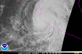
Update: NHC has indicated that at the time of landfall minimum pressure was 920 mb, and wind was 165 mph.
Oct 23, 2015
Hurricane Patricia Landfall
Update: NHC has indicated that at the time of landfall minimum pressure was 920 mb, and wind was 165 mph.
Hurricane Patricia
Hurricane Patricia has intensified at an incredible rate over the last 24 hours. At 4 AM CDT yesterday (Oct 22), Patricia was a 75 knot hurricane; by 4 AM today, based on data from the Hurricane Hunters, it was at 175 knots. This makes Patricia the strongest hurricane on record for the NHC's area of responsibility, which includes the East Pacific and Atlantic. The minimum central pressure was estimated at 880 mb, another record for the East Pacific/Atlantic. The previous record was Hurricane Wilma at 882 mb. The record lowest pressure globally was Typhoon Tip in the West Pacific.
Hurricane Patricia should make landfall near Puerto Vallarta tonight. In addition to catastrophic storm surge and wind damage, flash flooding and mudslides will be a major problem, because Patricia will be moving directly into mountainous terrain.
Hurricane Patricia should make landfall near Puerto Vallarta tonight. In addition to catastrophic storm surge and wind damage, flash flooding and mudslides will be a major problem, because Patricia will be moving directly into mountainous terrain.
Oct 3, 2015
Hurricane Joaquin Strengthens
At 12:00 PM EDT, data from a Hurricane Hunter plane prompted the NHC to increase the intensity of Joaquin to 135 knots (155 mph), and drop the minimum central pressure to 933 mb. Joaquin is expected to miss the US, but there is still some chance for it to pass close to Nova Scotia. Joaquin is moving north into areas with increasing shear and should not strengthen any further.
As tropical moisture, some of which is associated with Joaquin, has been forced into a front along the East Coast, over 14" was reported near Wilmington, NC over the last 2 days.
Oct 1, 2015
Hurricane Joaquin
Hurricane Joaquin has encountered water temperatures around 85F, and decreasing shear as it moves into the Bahamas. This has led to Joaquin strengthening from 70 knots to 110 knots over the last 24 hours. A trough over the southeast US should begin to turn Joaquin to the north within 24 hours. Ridging is forecast to develop over New England by Saturday, Oct 3. Although the models are still split, it is possible that the ridge will turn Joaquin westward and into the East Coast. This is a pattern similar to the one for Hurricane Sandy. Right now, models indicate that landfall may occur anywhere from South Carolina up to Newfoundland.
As Joaquin moves north, it will remain in water that is at least 80F until it moves north of Cape Hatteras. The depth of warm water will be sufficient to sustain a major hurricane as well:
Even if Joaquin does not landfall, tropical moisture will be absorbed into the southeast US trough and produce flooding across the East Coast region:
Depth of the 26C isotherm
Subscribe to:
Posts (Atom)


