Dec 29, 2009

Christmas Storm


A monstrous Christmas storm which set snowfall records from Bismarck, ND to Dallas, TX dumped over two feet of snow on the northern Plains and over four feet in the Black Hills of South Dakota. It wasn't just the snow that set records but also the rain. At Little Rock, Arkansas, 9.60" of rain pushed the annual total to 81.76, breaking the old record of 75.54 set in 1882. The storm also produced a significant tornado outbreak from Texas to Mississippi including an EF3 on the night of December 23rd in Lufkin, Texas.

At it's peak, the storm maintained a minimum pressure of 985 mb (29.09 inches) for a solid 12 hours.
click for animation
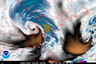
But what made this storm so unusual was how far south the strong dynamics were able to penetrate. I remember seeing the barometer reading at Del Rio, TX (on the Mexican Border) being at 29.53 inches (1000 mb)...long before the storm bottomed out in Iowa. Water vapor imagery of the storm at it's peak strength tells the whole story:
click for animation
Note that lightning is also plotted and is visible along the gulf coast and over Oklahoma during the blizzard. Here is a longer loop:A full six day loop of the entire event:

Higher resolution available here.

This is how the watches/warnings looked at the height of the storm (blizzard warnings in red).I have never seen such a large area under a blizzard warning at one time. Those blizzard warnings were extended westward into most of the rest of Nebraska the following day as the storm retrograded through Iowa.At Kansas City, where the first blizzard warning in 27 years was issued, 3.7 inches on Christmas was enough to break the record of 2.5 inches set in 1895. The storm total for the Kansas City area was in the 6-12" range. New Christmas snowfall totals were established at Grand Island, Ne (7.8") and Hastings, Ne(9.2"). The storm total was 12.2" at Grand Island and 14.3" at Hastings where the snow drifts were big enough to bury a car at the Weather Service Office:Omaha, Lincoln, and Norfolk all set new snowfall records for December, and Topeka, KS may be next. Snowfall from this storm was 12.9" at Lincoln, 11.5" at Omaha, and 19.1" at Norfolk. Accumulations were as high as 3 feet in the Sand Hills area and up to 52" in the Black Hills in South Dakota. At Sioux Falls 19.0" was the 4th highest storm total ever recorded. 2 foot snow accumulations were reported in the Sioux Falls area, in several areas elsewhere in South Dakota,
and especially around Grand Forks, ND. Even Bismarck, ND set a Christmas snowfall record (9.2"). Oklahoma City received 14.1", - the highest 24 hour total ever. Dallas had 3" which was the only measurable snow on Christmas eve since 1898.

The next storm is already on the way, and winter weather advisories are now active for most of Oklahoma and northern and western Texas going all the way down to Sonora. A winter storm warning has been issued for El Paso.

Dec 23, 2009

Jamaican Plane Crash & Winter Weather

The deep subtropical trough that I mentioned in yesterday's post is responsible for the powerful storms in the Caribbean that are the likely cause of a plane crash in Kingston, Jamaica last night. The crash occurred at 322Z (10:22PM local time) in heavy rain and with a ceiling of 1,400 feet (details here). The following satellite images are from 315Z and 345Z (7 minutes before and 23 minutes after the crash).Water vapor images for the same times:Although the heaviest storms and coldest cloudtops do not appear to be over the exact location of the crash, there are some storms backbuilding across southeast Jamaica between 3 and 4Z. This can be seen more easily in color enhanced images:Close-up of 3Z:
Close-up of 4Z:
Rain was not reported at the airport until 1Z, and heavy rain not until 3Z. Wind was from the northwest at 8 knots at 3Z, but increased to 14 by 4Z. Even more telling, visibility was 5 km at 228Z, 3 km at 300Z, and 1.5 km by400Z. It is easy to see how a crash could have occurred under such rapidly deteriorating conditions. Here is the last useful visible image from yesterday.This is all a result of a large upper trough extending down into Central America.A surface trough of 1008 mb develops about 100 miles southeast of Jamaica by 6Z.Meanwhile, another incredible storm has almost all of the Plains and upper Mississippi Valley under a winter storm warning (pink), areas near Chicago an ice storm warning (purple), and the deep south under tornado watches and warnings (yellow and red), and it is only getting started.And Europe also continues to get almost nonstop brutal winter weather including temperatures to -20C in Poland, -33C in Germany, crippling snowstorms in Moscow, and unusual heavy snow in Milan, Italy. See more here.

Dec 22, 2009

Deep Trough & Snowfall Totals

An unusually strong and deep subtropical upper trough is moving across Central America today. On the 6Z 200 mb analysis chart (3rd one down) a 100 knot southwesterly wind flag is located over Honduras.
Over the weekend, a massive blizzard hit the East Coast with 19.3" at Dulles International and up to 30" in western Virginia, 23.2 at Philadelphia - the second highest on record with thunder, 14.2 at JFK Airport and 26.3 at the NWS office on Long Island. Here are more totals from HPC:

...SELECTED STORM TOTAL SNOWFALL IN INCHES FROM 100 AM EST FRI DEC
18 THROUGH 300 PM EST SUN DEC 20...

...MASSACHUSETTS...
BOURNE 21.5
KINGSTON 21.0
NEW BEDFORD 20.0
MIDDLEBORO 18.5
MENDON 17.0
ATTLEBORO 15.8
GLOUCESTER 14.5
FOXBOROUGH 14.0
WAYLAND 14.0
BOSTON LOGAN ARPT 9.0

...MAINE...
HAMPSTEAD 5.4
HAMPTON 5.0
KITTERY POINT 4.5

...RHODE ISLAND...
WEST GREENWICH 22.0
WARREN 21.0
NEWPORT 20.5
SOUTH KINSTOWN 19.9
PORTSMOUTH 19.5
CHARLESTOWN 19.2
WOONSOCKET 19.0
CRANSTON 17.0
WEST WARWICK 17.0
CUMBERLAND 15.9

...SELECTED PEAK WIND GUSTS IN MILES PER HOUR EARLIER IN THE
EVENT...

...MASSACHUSETTS...
PROVINCETOWN 65
NANTUCKET 63
BARNSTABLE 62
HYANNIS 54
FALMOUTH 52

...SELECTED STORM TOTAL SNOWFALL IN INCHES WHERE THE EVENT HAS
ENDED...

...CONNECTICUT...
CLINTON 20.0
EAST HADDAM 20.0
NORWICH 20.0
PUTNAM 20.0
GROTON 18.0
EAST KILLINGLY 15.7
MANSFIELD 15.5
EASTFORD 14.5
STERLING 14.5
NORTH BRANFORD 12.0

...WASHINGTON, DC...
AMERICAN UNIVERSITY 16.0
THE MALL 16.0

...DELAWARE...
DOVER 18.0
BEAR 17.0
WILMINGTON 17.0
NEWARK 16.1

...KENTUCKY...
HARLAN 7.0
BEATTYVILLE 6.0
WILLIAMSBURG 1NNW 6.0

...MARYLAND...
OLNEY 23.3
BETHESDA 23.0
COLUMBIA 23.0
DERWOOD 23.0
SIMPSONVILLE 1 SSE 22.9
GAITHERSBURG 1 NW 22.0
GERMANTOWN 22.0
MILLINGTON 22.0
ANNAPOLIS 20.8
FREDERICK 19.0

...NORTH CAROLINA ...
ROBBINSVILLE 12 W 24.0
ASHEVILLE 17.0
BOONE 16.0
EAST MARION 15.0
RUTHERWOOD 15.0
FLEETWOOD 14.0
WAYNESVILLE 13.8
WEST JEFFERSON 13.0
MARSHALL 7 N 12.0
GREENSBORO 4.5

...NEW JERSEY...
FOLSOM 25.7
SWEDESBORO 25.0
TABERNACLE 24.8
ATCO 24.0
MEDFORD 24.0
PITTSGROVE 23.5
BRICKTOWN 22.0
CHERRY HILL 19.5
MOUNT HOLLY NWS 16.6
ATLANTIC CITY 12.1

...NEW YORK...
UPTON 26.3
MOUNT SINAI 24.0
ISLIP 23.9
SAG HARBOR 20.0
MEDFORD 18.0
PLAINVIEW 15.2
NYC/JFK ARPT 14.5
LONG BEACH 12.5
BROOKLYN 11.8
NYC/CENTRAL PARK 10.9

...OHIO...
BRIDGEPORT 5.0

...PENNSYLVANIA...
PHILADELPHIA INTL ARPT 23.2
SHARON HILL 23.0
SOUTH MOUNTAIN 22.0
BROGUE 20.0
QUARRYVILLE 20.0
RAINSBURG 19.5
WEST CALN 19.3
ORRTANNA 17.2
ROCKLEDGE 16.5
WEST CHESTER 15.4

...VIRGINIA...
INDIAN VALLEY 26.0
MUSTOE 25.4
FISHERVILLE 25.0
ROCKY BAR 3 ENE 24.0
CROZET 1SSE 23.0
COVINGTON 22.6
CENTREVILLE 1 SE 22.0
ALEXANDRIA 19.0
DULLES INTERNATIONAL 16.0
REAGAN NATIONAL ARPT 15.4

...WEST VIRGINIA...
MARLINTON 26.0
FRIARS HILL 25.0
HORSE SHOE RUN 25.0
BECKLEY 24.0
HENDRICKS 24.0
JUMPING BRANCH 24.0
CANAAN VALLEY STATE 3SW 22.0
WILLIAMSBURG 22.0
GRANDVIEW 21.0
CHARLES TOWN 18.0

...SELECTED STORM TOTAL RAINFALL IN INCHES WHERE THE EVENT HAS
ENDED...

...SOUTH CAROLINA...
MCCLELLANVILLE 5.96
MOUNT PLEASANT 1 NE 5.38
ISLE OF PALMS 4.80
CHARLESTON 3.93
FORT JOHNSON 3.51
NORTH MYRTLE BEACH 2.96
GOOSE CREEK 4 SE 2.90
HUGER 3 NNE 2.80
BEAUFORT 2.55
WITHERBEE 2.44

The next big winter storm is on the way and heavy snow is already falling in western Colorado.

Dec 18, 2009

Global Warming?

As President Obama returns from the global warming summit in Copenhagen, where it has been snowing since Tuesday, a massive snowstorm is just now moving into Washington DC, with around two feet of accumulation likely.Long Island is under a blizzard warning and will likely get around 15 inches. Severe thunderstorms swept through Florida today including one which produced a tornado on Key West. Heavy rain hit New Orleans yesterday and brought the monthly total to 24.25 inches. Looking upstream, another brutal storm is on the way which could hit the Midwest with two feet of snow and the lower Mississippi Valley with a major tornado outbreak next week.In Valdez, Alaska, a storm of 972 mb, with a track from 37N, 160W, (straight north of Kauai) to southeast Alaska, put down over 6 feet of snow.

In Moscow, heavy snow fell on December 7, and fell for ten days in a row, from December 5 to December 14, followed by temperatures dropping to -18F. The mayor who wanted to use cloud seeding to stop it from snowing, is now blaming weather forecasters.

Snow even fell in Melbourne, Australia (latitude 37S) on December 10th - despite being only three weeks from the solstice.

Snowcover for the northern hemisphere is more extensive then normal, particularly for Europe and Asia.The fact is, heavy snow, floods, tornadoes, and all of the above are entirely inconsistent with greenhouse warming. According to every global warming computer model, greenhouse warming should be strongest in polar regions especially in winter, and in the upper troposphere in the mid-latitudes and tropics. This would weaken meridional temperature gradients and reduce vertical lapse rates thus weakening jet streams and reducing thermodynamic instability.

Dec 10, 2009

Review Of Monster Winter Storm

An unusually strong early December winter storm tracked from central California on Monday, Dec 7th, to Lake Huron Wednesday, Dec 9th where its pressure fell to 974 mb (28.75 inches). Blizzard conditions and 12"+ snow accumulations across the Midwest occurred north of the storm's track. Up to 4 feet of snow fell on the Sierra Nevada Range, 33" in western Colorado, 18" at Carson City, Nevada, 13.7" at Reno, Nevada, and 30.4" at Flagstaff, AZ. As the storm ejected into the Plains on Tuesday, Dec 8th, jet stream energy coming around the base of the upper trough produced a wind gust of 105 mph at Guadalupe Bowl near the Texas-New Mexico border. That jet stream energy caused the surface trough to deepen rapidly in Missouri and produce the second earliest blizzard on record for the area covered by the National Weather Service Office in Kansas City. Snowfall amounts across the Midwest include: 6" at North Platte, NE, 9.4" at Omaha, NE, 8" at Salina, KS, 12.7" at Des Moines, IA, 11.8" at Rochester, MN and 18.5" at Madison, WI (see photos here). As the storm moved through Grand Rapids, MI on Wednesday, it set a new record low pressure for December. Mount Mansfield, VT reported a wind gust of 108 mph, with 60 mph+ wind gusts common at lower elevations throughout the Northeast. Even now as the storm moves well into Canada, lake effect snow and blizzard conditions continue for southwest Michigan as 850 mb temperatures over Lake Michigan drop to around -20C.

After a 948 mb storm reached down to 41N latitude in the Pacific Ocean on December 5, (see this post), Hawaii is getting the biggest waves they've had in 5 years. See story and pictures here.

Dec 8, 2009

Major Blizzard Continues

Almost the entire lower 48 is being affected by a massive winter storm today. This a storm which yesterday prompted blizzard warnings for Albuquerque, NM, and Flagstaff, AZ, where 11.6" of snow fell. Up to 3.5 feet came down on the Sierra Nevada Range, but even in Nevada, where it is normally much drier, 18" fell at Carson City, and 12" fell near Reno. This morning, the storm reached a strength of 980 mb near Grand Junction, CO, despite its unfavorable position to the west of the tallest mountains.Currently blizzard warnings (red) are active for a large portion of the Midwest including all of Iowa and most of Wisconsin.Winter storm warnings extend out much further (notice New England as well), and winter weather advisories extend even farther still. The fact is, almost every advisory on this map is related to this one storm - from the storm warnings on the Great Lakes (purple), to the tornado watch for the lower Mississippi Valley (yellow), to the wind chill advisories in the Northern Plains (light blue), to the very widespread wind advisories (brown/tan) going all the way over to Georgia. Because of the cold backwash, frost and freeze advisories are active for all the suburbs of San Francisco, and all of the San Joaquin Valley is under a freeze warning including Bakersfield. Temperatures have already dropped to -33F in Cut Bank, MT this morning. Great Falls hit -26F at 7AM local time, but even at this hour (3PM), it is only -11F.

Another incredible storm in the north Atlantic yesterday was the strongest so far this season at 942mb.

Dec 6, 2009

This Is No Pineapple Express

Despite an ongoing El Nino, the Walker circulation has remained at near normal strength, and the dominant storm track has been from the North Pacific or even straight from the Arctic Circle. The jet stream can be traced from Barrow, Alaska to Las Vegas, Nevada.The strong anticyclonic curvature and convergence over the Yukon helped to produce an incredible 1061 mb (31. 33 inches) surface high pressure cell.Polar airmasses have penetrated so deeply in this pattern that Houston had its earliest snowfall ever on Friday. Snow even fell at Galveston, TX, Slidell, La and Galliano, LA, which is about 40 miles south of New Orleans. The snowstorm then hit all the major cities along the east coast on Saturday, from Washington D.C. to Boston. Last night, Las Vegas, Tucson, and every county in southern Texas except Cameron (i.e. Brownsville) were under freeze warnings. Tonight, (Sunday morning) Freeze warnings run from New Orleans to the entire Florida Panhandle, frost advisories are in place for the northern half of the San Joaquin Valley in California, with freeze watches going down to Bakersfield.The next system is already getting started with blizzard warnings active in western Colorado. Another much larger storm will rapidly intensify in California on Monday and has prompted winter storm watches all the way down to southeastern Arizona. This storm will also likely dump at least several feet of snow on the higher mountains in Utah and Colorado and up to around one foot from parts of the central Plains to the western Great Lakes.

In the Pacific, the polar jet stream has amplified enough to get a 948 mb storm to form down to 41N latitude - no pineapple express here.