Over the past several days (Dec 26 - Dec 28) a major winter storm hit the central US. Winter storm warnings stretched almost from the Canadian Border to the Mexican border:
Blizzard warnings were issued for west Texas, where up to two feet of snow fell (Queen). At Lubbock, 11" of snow fell, a state of emergency was declared, and a roof collapsed at a mall. Sleet accumulated to 3.4" at Rockford, IL and 4.8" at Springville, IA. 1" of freezing rain fell at Anthony Kansas and Kewanee, IL, but some areas had problems with just 0.25" of ice because of the strong winds: in the Peoria area 70,000 customers lost power, and a gas line was ruptured.
In Missouri, flooding closed parts of I-70 and I-44. 12.25" of rain fell at Union, MO, causing record flooding. At Springfield, MO the 6.03" that fell on December 26th was the second highest 24 hour total on record. The storm total there was exactly 10.00". At least 13 flood related fatalities occurred across Missouri.
On December 26th, tornadoes killed 11 in Texas. 8 of the fatalities were from an EF-4 that hit Garland, TX:
At 5 PM CDT, the eyewall of Patricia is over San Patricio. Current intensity is 900 mb, wind 165 knots (190 mph). Peak intensity was at 1 PM: pressure 879 mb, wind 175 knots (200 mph).
Update: NHC has indicated that at the time of landfall minimum pressure was 920 mb, and wind was 165 mph.
Hurricane Patricia has intensified at an incredible rate over the last 24 hours. At 4 AM CDT yesterday (Oct 22), Patricia was a 75 knot hurricane; by 4 AM today, based on data from the Hurricane Hunters, it was at 175 knots. This makes Patricia the strongest hurricane on record for the NHC's area of responsibility, which includes the East Pacific and Atlantic. The minimum central pressure was estimated at 880 mb, another record for the East Pacific/Atlantic. The previous record was Hurricane Wilma at 882 mb. The record lowest pressure globally was Typhoon Tip in the West Pacific.
Hurricane Patricia should make landfall near Puerto Vallarta tonight. In addition to catastrophic storm surge and wind damage, flash flooding and mudslides will be a major problem, because Patricia will be moving directly into mountainous terrain.
At 12:00 PM EDT, data from a Hurricane Hunter plane prompted the NHC to increase the intensity of Joaquin to 135 knots (155 mph), and drop the minimum central pressure to 933 mb. Joaquin is expected to miss the US, but there is still some chance for it to pass close to Nova Scotia. Joaquin is moving north into areas with increasing shear and should not strengthen any further.
As tropical moisture, some of which is associated with Joaquin, has been forced into a front along the East Coast, over 14" was reported near Wilmington, NC over the last 2 days.
Hurricane Joaquin has encountered water temperatures around 85F, and decreasing shear as it moves into the Bahamas. This has led to Joaquin strengthening from 70 knots to 110 knots over the last 24 hours. A trough over the southeast US should begin to turn Joaquin to the north within 24 hours. Ridging is forecast to develop over New England by Saturday, Oct 3. Although the models are still split, it is possible that the ridge will turn Joaquin westward and into the East Coast. This is a pattern similar to the one for Hurricane Sandy. Right now, models indicate that landfall may occur anywhere from South Carolina up to Newfoundland.
As Joaquin moves north, it will remain in water that is at least 80F until it moves north of Cape Hatteras. The depth of warm water will be sufficient to sustain a major hurricane as well:
Depth of the 26C isotherm
Even if Joaquin does not landfall, tropical moisture will be absorbed into the southeast US trough and produce flooding across the East Coast region:
During El Ninos, the Atlantic hurricane season is usually quieter than normal, and the east and central Pacific is often more active than normal. In the image above, from left to right, we have Hurricane Kilo (winds 110 knots), Hurricane Ignacio (winds 120 knots), and Hurricane Jimena (winds 130 knots).
A strong El Nino has developed with sea surface temperature anomalies reaching 3C. This El Nino should persist, and possibly strengthen even further because subsurface water temperature anomalies are 6C at the 50-100 meter depth in the Eastern Pacific:
Impacts from this El Nino could include reduced Atlantic hurricane activity, and much needed rain in California. El Ninos, particularly strong ones, are usually associated with warm winters in the northern US, but some cold outbreaks may be possible this time, because of a westerly QBO.
Theodor Landscheidt believed that ENSO events are correlated to solar subcycles which have enhanced x-ray flare activity. The Southern Oscillation Index (SOI) was used, because it changes before temperatures do. Significantly anomalous values in the SOI go back to August of 2014. It was only in July 2015 that the SOI indicated a strong El Nino, but trade winds were weaker than normal (westerly anomalies, shown in red below) for many months before that:
X-ray flares did increase in August 2014 right when SOI indicated the beginnings of El Nino:
Don Easterbrook has noticed that El Ninos correlate to spikes in the AP index (indicates geomagnetic activity). In March, the AP index reached the highest value since September 2005:
Yesterday, this storm in Boone County, IL damaged trees and power lines, and produced golf ball size hail near Poplar Grove, IL:
There was also a weaker cell to its south:
And this one to its southwest:
We were driving north on I-39 just north of US 34 at the beginning of the video below. At that time the storm was probably 50 miles away. The video runs from 8:46 - 9:12 PM CDT as we go through LaSalle, Lee and Ogle counties.
Here is the storm from up close. We are driving east on 173 between I-39 and 76 from 9:37-9:41 PM CDT.
Yesterday (June 20th), we were storm chasing eastern in Iowa. We saw a very well defined shelf cloud associated with a severe squall line which had horizontal rotation at Wayland, IA. This was from 7:00-7:05 PM CDT:
6 minutes later, and a little east of Wayland on highway 78:
A view from directly underneath the shelf cloud at the junction of 78 and US 218 at 7:14 PM:
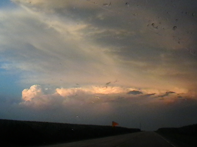
While we were on our way home after the storm chase, we encountered a spectacular sunset near Muscatine, IA. We were able to see lightning from the storm to our east, a rainbow, crepuscular rays, and even anti-crepuscular rays. This was from 8:19-8:34 PM CDT.
On May 8th and 9th, a mid-level jet streak emerged into the Central Plains, triggering severe weather. Here are the storms that we saw. On Friday, May 8th, we tracked a supercell along the Red River Valley. We first intercepted it at the junction of US 183 and 287 east of Vernon, TX. This video is from while we are driving east on 287 near Harold, TX from 4:50-4:58 PM CDT:
This one is while we are driving north on 1739 and then east on 240 from 5:16-5:19 PM CDT:
We followed it into far southern Oklahoma, heading east on US 70. This is from just east of Randlett from 5:50-5:53 PM CDT.
The view from the junction of US 70 and 65 was had low contrast, but there was starting to be some good lightning. This was from 6:14-6:18 PM CDT:
From 6:31-6:41 PM CDT the structure had become impressive, there was more intense lightning, and the storm was producing a constant low rumbling sound. We are on US 70 west of Waurika and south of Hastings.
One more good view from Waurika, at the intersection of US 70 and US 81 from 6:54-6:59 PM CDT:
On May 9th, we caught a storm that had recently developed in the Texas Panhandle along a dry line, and moved into the Oklahoma Panhandle. We are on US 64 about 5 miles northeast of Beaver, east of Forgan, and east of highway 23. This is from 6:35-6:36 PM CDT on May 9, 2015:
These next three are from the same spot, at 6:45-6:46, 6:48, and 7:01-7:03 PM CDT:
This one is from a little further east on US 64 from 7:15-7:17 PM CDT:
The next video is from Kansas highway 34, north of US 160, northeast of Ashland, and west of Coldwater. This was from 8:26-8:27 PM CDT:
As we continued north on 34, the storm intensified. This was from 8:29-8:37 PM CDT, and towards the end of the video, we are nearing Bucklin and US 54:
At the beginning of the next video, we are at Bucklin, on Kansas highway 34, just south of US 54 seeing excellent storm structure. We then drive east on 54, then north from Mullinville. This was from 8:38-8:58 PM CDT:
The same synoptic scale system responsible for these storms also produced blizzard conditions in western South Dakota.
Today is the 8th anniversary of the F-5 Greensburg tornado. The Greensburg tornado developed at night, so it was only visible when illuminated by lightning. So, I made a video showing just the frames with best lightning illumination. All of the frames that reveal the tornado were taken from highway 183 south of Greensburg, looking west at first, then later looking north. The tornado began to hit Greensburg at 2:10. The final one is from highway 160, looking at the storm to our northeast, over 100 miles away, and with lightning shooting out the top.
A tornado outbreak occurred across eastern Iowa and Northern Illinois today, April 9. Here is what we saw. A funnel cloud formed to our north as we drove west on I-80 from the junction with 280 near Davenport, Iowa. The video ends at 5:15 PM CDT and two minutes later, a tornado was reported to the northeast near Donahue:
An intense supercell produced a tornado that caused damage at Ashton, Rochelle, Fairdale, and Kirkland in Lee, Ogle, and De Kalb counties in Illinois. We got our first good look at this storm when it was near Rochelle, while we were to the the southwest on I-88 near Ashton. This video runs from 7:02-7:04 PM CDT on April 9, 2015:
It became more clear how intense this storm was as we approached Rochelle, as spectacular lightning became very frequent. We are at the junction of I-88 and Illinois 251 at the beginning of the video, and near the junction of I-39 and Illinois 72 by the end. The video runs from 7:08-7:23 PM CDT on April 9, 2015:
Thursday, April 9 is the 4th anniversary of the EF-3 Mapleton, IA tornado. I have video from Onawa, IA from 6:43 - 6:56 PM CDT - about 40 minutes before Mapleton was hit - of what may have been the beginnings of the Mapleton tornado:
From just east of Onawa, on highway 175, from 7:00 - 7:03 we saw a circulation cross the road to our west:
I have plenty of video from this storm, and we only saw the tornado after dark, so I made a slideshow to show how it all evolved:
The winter of 2014-2015 has been a temperature roller coaster, particularly for the Midwest. November was already winter-like, with a large part of the Midwest 7F below normal:
Almost the entire contiguous 48 was above normal in December:
January was cold in the east and south:
Persistent eastern troughing produced temperatures 11 - 14F below normal for most of the Great Lakes and Northeast in February:
On February 19th, arctic air moved into the eastern US:
Hard freeze warnings went to Daytona Beach, freeze warnings went to near West Palm Beach, and a wind chill advisory was issued for Miami:
Numerous low temperature records were set on Feb 20th, and many by a wide margin:
new old
Location record record year
Marquette -26 -15 1966
Detroit -12 -8 1934
Cincinnati -12 -7 1885
Pittsburgh -10 -2 1968
NYC Central Park 2 7 1950
Washington DC 5 8 1896
Charleston 18 22 1968
Macon 18 21 1958
Jacksonville 24 28 1958
Vero Beach 30 35 1958
West Palm Beach 38 42 1958
Naples 36 39 1960
Key West 49 52 1958
The low of -10 at Pittsburgh was the lowest temperature this late in the season since records began in 1871.
This morning, Chinook winds produced 850 temperatures over 20C across the Central Plains:
With cold, stable air still in place at ground level, a temperature inversion of over 20C (36F) was present in the Central Plains. At North Platte, NE, the temperature increased by 20C only about 200 meters above ground level:
A Nor'easter hit the East Coast with blizzard conditions and 3 feet of snow over the last two days (Jan 26-28). Blizzard warnings (red) were issued along the coast from New Jersey to Maine, and hurricane force wind warnings (brown) for an area around Cape Cod:
The heaviest snow (3 feet) fell only 30-50 miles from the coast in Massachusetts (Auburn, Hudson, Lunenburg). Winds gusted to 75 mph on Cape Cod (Chatham), and 78 mph on Nantucket. NAM analysis charts for Tuesday morning indicate a huge mid level trough, and an 80+ knot low level jet going across a 20C temperature gradient:
32.2 foot waves were recorded at buoy 44037 (well northeast of Boston).
I am a self taught meteorologist and storm chaser. Much of my original interest came from Joe D'Aleo. I was later interested in the work of Theodor Landscheidt. My views on politics and economics are very close to those of Walter E Williams.


