Oct 31, 2011

October 29 2011 Snowstorm


On October 29th, this nor'easter dropped up to 31.4" (Jaffrey, NH) of snow, and knocked out power to over 3 million customers throughout the Northeast. Snow fell on Occupy Wall Street. The 2.9" that fell in Central Park was the most for the month of October since records began in 1869. An inch of snow had never before been recorded in October. The last two times measurable snow fell in October were Oct 21 1952 with 0.5", and Oct 30 1925 with 0.8". Up to 19" fell in New Jersey (West Milford), and 9" in Virginia (Skyland). 5.2" fell at Newark Airport, 1.7 " at La Guardia, 1.5" at JFK, and 0.3" at Islip. Nantucket recorded wind gusts to 60 knots.

Snow cover at 6Z (2AM EDT) on the 30th:
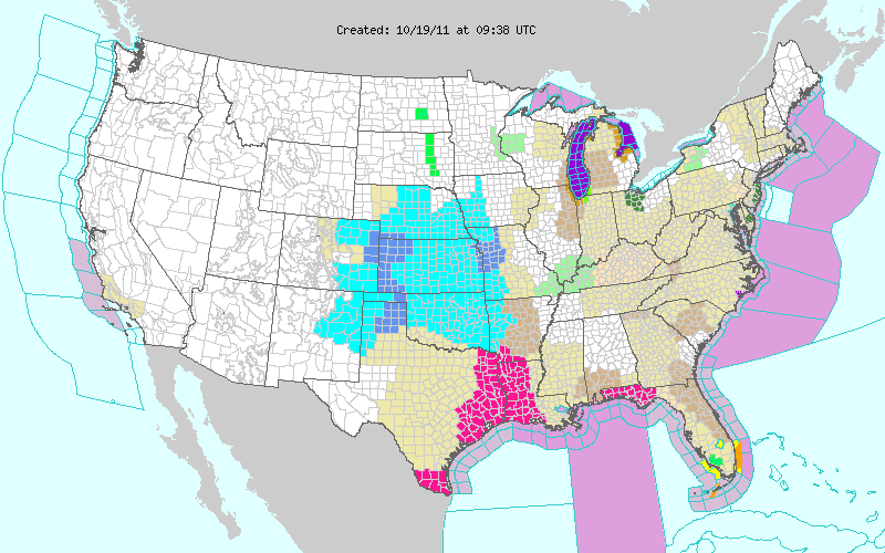
The warnings issued for this storm include: a winter storm warning (pink) from Virginia to Maine, storm warning (purple) from the coast of Long Island to Maine, hurricane force wind warning (brown) farther offshore, freeze warning (light blue), and frost advisory (blue).
72 hour water vapor loop of the entire event:

48 hour infrared loop:

Two day visible loop:

RUC 500 mb analysis for the evening of the 29th:
The 850 mb temperature gradient was over 20C over only about 200 miles:
The result was a 20 mb pressure drop in just 18 hours - from 996 at 21Z to 976 by 15Z on the 30th:
Soundings from Washington DC, New York, and Albany, NY respectively:
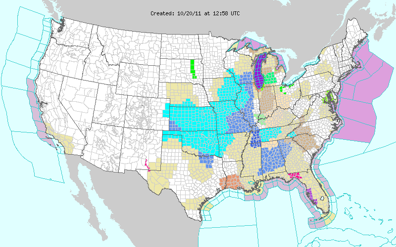
Frost advisories were later extended to southern Alabama and the rest of South Carolina except the coast:

Oct 28, 2011

Hurricane Ophelia and Heavy Snow

The 992 mb Lake Michigan storm from September 29th mentioned in my last post kicked up enough sediment on Lake Michigan to be visible in an Aqua satellite image:
I noticed that it was still present on October 9th in geostationary imagery, as well as on Lake Erie:
This is category 3 Hurricane Ophelia on September 30th north of the Lesser Antilles:
There appears to be some low level outflow on its west side.

Ophelia passing to the east of Bermuda on October 1st:
Three hours after this last image (0Z Oct 2nd), Ophelia was upgraded to a category 4. Peak strength was estimated to be 940 mb/120 knot winds at 3Z Oct 2nd.

Ophelia weakening and moving north toward Newfoundland on October 2nd:
On October 5th, this large western trough produced heavy snow for the entire Sierra Nevada Range.
On the morning of October 6th, this system produced 11 tornadoes in the Flagstaff area, including 2 EF-3s, with temperatures only in the 40s. Flagstaff was under a freeze warning for the morning after the tornadoes struck:
Flagstaff had a low of 27 on October 8th. Note also the frost advisories for the suburbs of Boston, and the tornado warning in Kansas, which was for this cell:
The energy which produced the Flagstaff area tornadoes in the morning had already ejected into the Plains to generate a 988 mb low in the Nebraska Panhandle:
This was in an area with only upper 50s dew points:
But with surface winds up to 30 knots and backed to near southeasterly, helicity values were strong across the Central High Plains:
Another impressive cell developed near Grand Island, NE on October 7th:
A touchdown was reported with this cell in Scott County at 510Z:
On October 6th and 7th, snow fell in northern Arizona and northern New Mexico:
6 inches of snow fell on Cheyenne, WY on October 8th.

And heavy rain fell in Texas:
Areas of Texas which are still in an exceptional drought were under flash flood watches:
Freeze warnings were in effect down to southern New Mexico.

On October 20th, this 983 mb storm prompted storm warnings for Lakes Huron and Michigan, and a high wind warning for the Chicago area:
The Harrison-Dever Crib, near Chicago, recorded a 64 mph gust. A large areas were under frost advisories (blue) and freeze warnings (light blue) following this storm, including the county north of Dallas, and the Florida Panhandle:
The low temperature at Mobile, AL on October 20th was 34. It was 36 at Tallahassee on October 22nd.

Cheyenne, WY received 9.3" of snow, and Denver 8.5" on October 25-26. Then on October 27th, 3.1" fell at Amarillo, TX, with 5" reported 6 miles to the southwest. Laramie, WY had a low temperature of -16 on October 27th, breaking the old record of 7 set in 1970.

NAM indicates that a major nor'easter could drop over a foot of wet snow tomorrow. An area along a line from Washington DC to Boston will be near the rain-snow line. It might even snow on Wall Street...

Sep 30, 2011

Typhoon Roke and Stronger Mid Latitude Storms

You can't always trust the barometer. On September 16th, Madison, WI (KMSN) reported a pressure of 30.34"/1027.7 mb and light rain. A shortwave trough was moving directly over a surface high and was still able to produce some light rain even as it encountered an increasingly confluent flow over the Great Lakes.

On September 19th, a 964 mb storm prompted hurricane force wind warnings for the Gulf of Alaska:
Same storm two days later:
This is category 4 Typhoon Roke on September 20th south of Japan with 115 knot (135 mph) winds:
It was a category 2/90 knot (105 mph) storm when it made landfall in southern Japan around 4:30Z on the 21st.
Tokyo was hit with 90 mph winds and 260,000 households lost power.

On September 20th, a 998 mb low produced a 75 mph wind gust at Bullhead, SD and a 66 mph gust at Pierre, SD.
Yesterday (September 29th), this 992 mb storm prompted storm warnings for Lake Superior and Lake Michigan:
Winds gusted to 60 mph at Sturgeon Bay Airport, 69 at Stannard Rock Lighthouse (Lake Superior), 69 at Sister Bay (Door County, WI), and 71 at Green Bay Lighthouse. At 3:50 AM toady, Buoy 45007 in south central Lake Michigan, 43 miles ESE of Milwaukee, reported 23 foot waves.