Showing posts with label warm. Show all posts

Mar 2, 2015

Winter Temperatures

The winter of 2014-2015 has been a temperature roller coaster, particularly for the Midwest. November was already winter-like, with a large part of the Midwest 7F below normal:
Almost the entire contiguous 48 was above normal in December:
January was cold in the east and south:
Persistent eastern troughing produced temperatures 11 - 14F below normal for most of the Great Lakes and Northeast in February:

Jul 21, 2014

Northern Plains Heat

Heat advisories stretch from Wichita Falls, TX to Duluth, MN today:
The temperature reached 108 in Winner, SD today, with dew point of 52. At York, NE the temperature was 97, the dew point 81, and the heat index 119.

Aug 1, 2012

Derecho and Heat Wave

On June 29th, a derecho swept from Illinois to the Mid Atlantic coast, causing widespread damage over a huge area:
22 people were killed, and power outages totaled over 4 million. A sounding from Wilmington, OH taken at 2:00 PM just ahead of the storms indicated that surface based CAPE was 6383 J/kg, and the lifted index was -15. RUC analysis continued to indicate 6000 CAPE ahead of the main line at 0Z, and a strong west-northwest mid level flow just behind it:


Temperatures ahead of the derecho were as high as 102, with dewpoint depressions well over 30F:
A major heat wave was affecting most of the central and eastern US throughout late June and early July. On Independence Day, excessive heat warnings (violet) were active from Omaha to Detroit:

Sep 11, 2011

July 2011 Heat Wave and Hurricanes

This is category 3 Typhoon Ma-on on July 16th in the West Pacific south of Japan:
Its peak strength was category 4 with winds to 115 knots (135 mph) on July 15th. It later struck southern Japan on July 19 as a category 1.

On July 16th, a dangerous heat wave prompted the issuance of excessive heat warnings (shown in violet) across most of the Midwest:
On July 17th, the 500 mb geopotential height at Omaha, NE (KOAX) was 6,000 meters:
SPC's mesoanalysis showed 9,000 CAPE in southeast North Dakota:
This produced a tornado in LaMoure County which was rated a high end EF3 despite being in a very rural area (population only 4,139 for the entire County).

By July 20th, the heat wave had spread into the Great Lakes:
And by the 21st, the East Coast:
At 21Z (4PM CDT) on July 20th, another questionable tropical system was named. Tropical Storm Cindy began at 35.2 latitude, 53.8 longitude and then moved to the northeast. It can be seen at the right edge of this water vapor image:
Meanwhile in the East Pacific, category 4 Hurricane Dora developed an enormous eye:
It reached a peak strength of 929 mb and 135 knot winds 11 hours later ( July 21, 15Z).

A July 29 marathon race in western Montana was canceled because of snow cover so deep that it covered the signs which mark the trails.

This is Typhoon Muifa from July 31st:
It was category 5 on July 30th with winds at 140 knots.

Feb 10, 2011

Southern Winter Storm and Big Pattern Change

On February 2nd, the low temperature at Laramie, WY was -39, breaking the old record of -30 set in 1956.

On February 6th, this Pacific storm brought another cold front to Hawaii:
The surface low was at 976 mb as far south as 36N latitude:
On February 8th, a storm near the southern tip of Greenland dropped to 948 mb:
A second storm to the southwest at 957 mb, is now (as of 18Z) at 950 mb just southeast of where the first storm had been.

Another major winter storm hit the south yesterday (February 9th), prompting winter storm warnings (pink) from Texas and Oklahoma to Alabama, and more hard freeze warnings (dark blue) for the Gulf Coast:Snowfall amounts were up to 25" in Oklahoma (Jay), and 24.5" in Arkansas. The 5.7" at Tulsa, OK pushed the seasonal total to 26.1", making this their snowiest winter on record (old record 25.6" in 1923/24).

Numerous new record low temperatures were set across Oklahoma on the 10th including 10 new all-time record lows (only 9 are shown), and even a new state record (-31 at Nowata):This storm also left 64.9% of the Contiguous US snow covered:
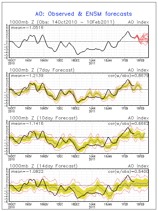
A major pattern change will occur next week, bringing much warmer air to the eastern US. This is likely related to the fact that the arctic oscillation recently went positive for the first time since mid November:
Sep 18, 2010

July 2010

On July 6th, this strong ridge over the Mid-Atlantic and Northeast produced numerous heat records.
Anthony Watts pointed out that some of the highest temperature readings including Baltimore may have been due to poor station siting.

On July 8th, an unusual winter-like Aleutian low dropped to 969 mb:
High resolution visible and water vapor imagery from the next day:
On July 23rd, a supercell in central South Dakota dropped a hailstone 8 inches in diameter, 18.625 inches in circumference, and weighing 1.9375 pounds in the small town of Vivian, SD, breaking the record for diameter and weight. The Aurora, Nebraska hailstone of June 22nd, 2004 had the previous record for diameter - 7 inches - and still holds the record for circumference - 18.75 inches. The old record for weight was 1.67 pounds on September 3rd, 1970 in Coffeyville, Kansas. The Vivian, SD supercell had an estimated updraft velocity in the 160-180 mph range. Analysis charts and radar imagery available here.

Nov 9, 2009

Siberian Cold And Hurricane Ida


While most of the United States enjoys a late-season warm spell, with Woodward Oklahoma reporting 90 degrees on both Friday and Saturday, Siberia is already experiencing temps down to -40. Compare the hemispheric 850 mb analysis chart from this time last year with the current one.
Meanwhile, category two Hurricane Ida is moving into moderately strong wind shear and water temperatures in the mid-70s in the northern Golf Of Mexico and should weaken considerably. The main impact will be flooding rains in areas that have already had more than enough.

As odd as it may seem, the Mid Atlantic may get the worst effects from wind and coastal flooding if Ida stalls out off the coast of North Carolina on Wednesday and produces an extended period of 40 knot+ onshore flow with the help of a 1030 mb high over the Great Lakes.