Just two minutes later, a tornado touches down in Scottsbluff. Although the tornado is very difficult to see, several power flashes are visible. The tornado was rated EF-1. This video runs from 7:23-7:24 MDT:
Aug 28, 2014
Storm Chases From 2010
On June 7th, 2010 at 7:22 MDT, a storm over Scottsbluff, NE began to rotate. We were so close, and the area of rotation so large, that it was difficult to fit it into the field of view:
Just two minutes later, a tornado touches down in Scottsbluff. Although the tornado is very difficult to see, several power flashes are visible. The tornado was rated EF-1. This video runs from 7:23-7:24 MDT:
40 minutes later, as we tracked the storm to Bridgeport, NE, it becomes the darkest storm I've ever seen. This is from 8:01-8:05 PM MDT, and sunset was at 8:25:
The next day, instead of storm chasing, we took a trip through Rocky Mountain National Park. A pileus cloud is seen at 6:20:
On June 11, we saw a storm with vertical (anticyclonic) and horizontal rotation 15 miles north of Strasburg, CO. We are on Headlight Road north of 112th Ave. This is from 4:57-4:59 MDT:
On July 22nd, we saw an intense storm with a well defined shelf cloud approaching Gorney Park in Caledonia, WI. This is from 8:01-8:04 PM CDT:
Just two minutes later, a tornado touches down in Scottsbluff. Although the tornado is very difficult to see, several power flashes are visible. The tornado was rated EF-1. This video runs from 7:23-7:24 MDT:


Aug 2, 2014
Super Typhoon Halong

Jul 29, 2014
Cold Waters and High Waves on the Great Lakes
Today station 45004 on Lake Superior is still reporting water temperature of just 38F. The normal for late July is in the mid 50s.
On Lake Michigan, 33 knot north winds produced 11.4 foot waves at the Michigan City, IN buoy yesterday morning. The large waves produced enough upwelling to drop the water temperature to 58.8 F at the southern Lake Michigan buoy. Water temperatures were around 61 before the big waves hit, which is already about 10 degrees below normal.
On Lake Michigan, 33 knot north winds produced 11.4 foot waves at the Michigan City, IN buoy yesterday morning. The large waves produced enough upwelling to drop the water temperature to 58.8 F at the southern Lake Michigan buoy. Water temperatures were around 61 before the big waves hit, which is already about 10 degrees below normal.
Jul 21, 2014
Northern Plains Heat
Heat advisories stretch from Wichita Falls, TX to Duluth, MN today:
 The temperature reached 108 in Winner, SD today, with dew point of 52. At York, NE the temperature was 97, the dew point 81, and the heat index 119.
Jul 10, 2014
July Cold
Cold air has spread across northern Wisconsin this morning. Rhinelander had a low temperature of 41, Eagle River 38, and Land O' Lakes 37. Temperatures will likely drop into the 40s in Iowa and Illinois by Monday night (July 14).
Jul 4, 2014
Hurricane Arthur Update
Hurricane Arthur has strengthened to category 2 with wind at 85 knots (100 mph) and a central pressure of 973 mb. Winds have gusted to 73 knots (84 mph) at Cape Lookout, NC and to 79.1 knots (89.9 mph) at Hatteras, NC. Station 41036 (south of Morehead City) has reported 28.9 foot waves. Hurricane Arthur is beginning to accelerate to the northeast and will impact New England and Nova Scotia tomorrow.
Some recent satellite and radar history of Arthur:


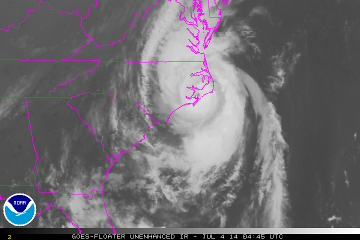


Some recent satellite and radar history of Arthur:
Subscribe to:
Posts (Atom)