The small cluster of convection just southeast of South Carolina was named Tropical Storm Alberto at 21Z on May 19th. RUC analysis indicates that Alberto was just downstream of an upper low and had a temperature at 850 mb of only 12C in the core.
How about this one?
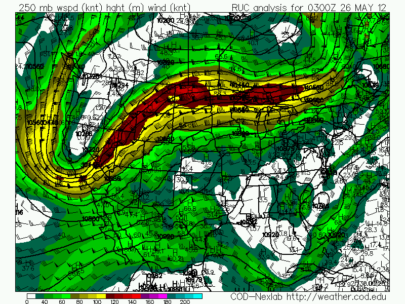
The area of convection just off the coast of The Carolinas was named Subtropical Storm Beryl at 3Z on the May 26th. It appears to be part of an extratropical system, with warm air advection occurring to its south and east. It does have a warm core, but it is still downstream from a broad upper low:
Beryl did later obtain tropical characteristics as it moved westward toward Florida.
At 3Z on June 19, the system south of Newfoundland was named Tropical Storm Chris:
It was at 39.3 latitude at the time it was named. Over the next two days, Chris took on an increasingly tropical appearance.
Sometime after the above satellite image, Chris formed an eye. It was named a hurricane on the 21st at 15Z.
It is not just a question of whether these marginal storms should be named, but also whether such storms would have been named in the past. For climatological purposes, it may be wise to completely ignore tropical storms, and look only at hurricanes. Or perhaps someone could attempt to determine which named storms need to be removed in order to have a consistent record.
On April 3rd, a tornado outbreak hit the Dallas-Fort Worth area, causing an estimated $1 billion in damage.
On April 11th, freeze warnings (light blue) were issued in the Southeast, and frost advisories (blue) went down to Macon, GA:
On April 14th, a huge tornado outbreak hit the Central Plains:
A 987 mb low was over eastern Colorado:
Over the warm sector in central Kansas, surface winds were southeasterly, 850 mb winds were south at 50 knots, 700 mb southwest around 45, and 500 mb southwest at 75:
RUC analyzed helicity mostly in the 400-500 range.
The second image is 0-1 km. The soundings from Dodge City and Topeka both show helicity over 600:
Radar imagery from a supercell in central Kansas around 2250Z (5:50 CDT) while it has an EF4 tornado on the ground near the Rice-Ellsworth County line:
I was out chasing that day and was able to get some good video of the tornado that that cell was producing at the exact time of the above radar images.
Immediately after this video, the tornado does this to a house 1 mile southwest of the intersection of Highways 4 and 141:
This is where the EF4 rating comes from.
We later saw another tornado just east of Salina produced by the same cell:
On April 22nd, a Nor'easter prompted winter storm warnings (pink) from New York to West Virginia:
On March 7th, a storm near Iceland reached 944 mb:
Northwest Pacific storm on March 12th:
On the afternoon of March 15th, several tornadoes touched down in eastern Michigan where 500 mb winds were only 25 knots.
This is a good example of the fact that there seems to be an exception to almost every rule in meteorology.
On March 18th, this intense western US trough dug into Mexico:
500 mb wind speeds reached 80 knots about 100 miles south of the border:
Winter storm warnings (pink) were issued in southeast Arizona down to the Mexican border, and winter weather advisories (purple) were issued for the Santa Ana Mountains:
Accumulating snow fell on the Mexican border south of Tucson:
On February 3rd, an Aleutian low was at 956 mb:
Another Aleutian low reached 948 mb on February 10th.
On February 11th, hard freeze warnings (dark blue) were issued down to the Gulf Coast, and winter weather advisories (purple) extended into central Texas:
On February 13th, yet another Aleutian low reached 944 mb.
These Aleutian lows were likely related to La Nna, which tends to favor a stronger polar jet stream.
This has been an especially brutal winter in parts of Europe, where over 550 people were killed, and 140,000 were trapped by snow. Some villages in Italy were buried under more than 9 feet of snow. In Romania, some people had to tunnel through 15 feet of snow to get out of their homes (video). The Danube River nearly froze over for the first time in 25 years. Ice in the Kerch Strait trapped 126 ships in the Sea of Azov. Heavy snow hit as far south as Turkey, and cold reached northern Africa.
A major tornado outbreak hit from Kansas to Tennessee on February 28-29, killing 13. 6 were killed by an EF4 in Harrisburg, IL on the morning of the 29th. This outbreak also included the first February tornado ever reported in Nebraska. By 6Z (midnight central time) on the 29th, a 70+ knot low level jet had spread over the warm sector across southern Missouri, producing helicity values off the charts even using the 0-1 km layer.
The surface low over southern Minnesota was at 986 mb at the time Harrisburg was struck.
I am a self taught meteorologist and storm chaser. Much of my original interest came from Joe D'Aleo. I was later interested in the work of Theodor Landscheidt. My views on politics and economics are very close to those of Walter E Williams.