observing and understanding the workings of the atmosphere
Jul 14, 2012
Rice County Kansas Tornado
On April 3rd, a tornado outbreak hit the Dallas-Fort Worth area, causing an estimated $1 billion in damage.
On April 11th, freeze warnings (light blue) were issued in the Southeast, and frost advisories (blue) went down to Macon, GA:
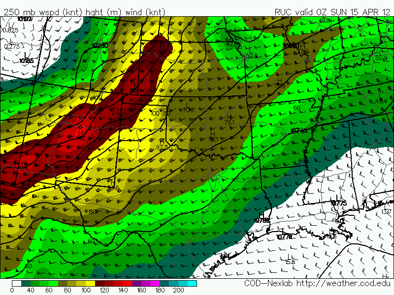
On April 14th, a huge tornado outbreak hit the Central Plains:
A 987 mb low was over eastern Colorado:
Over the warm sector in central Kansas, surface winds were southeasterly, 850 mb winds were south at 50 knots, 700 mb southwest around 45, and 500 mb southwest at 75:
RUC analyzed helicity mostly in the 400-500 range.
The second image is 0-1 km. The soundings from Dodge City and Topeka both show helicity over 600:
Radar imagery from a supercell in central Kansas around 2250Z (5:50 CDT) while it has an EF4 tornado on the ground near the Rice-Ellsworth County line:
I was out chasing that day and was able to get some good video of the tornado that that cell was producing at the exact time of the above radar images.
Immediately after this video, the tornado does this to a house 1 mile southwest of the intersection of Highways 4 and 141:
This is where the EF4 rating comes from.
We later saw another tornado just east of Salina produced by the same cell:
On April 22nd, a Nor'easter prompted winter storm warnings (pink) from New York to West Virginia:
I am a self taught meteorologist and storm chaser. Much of my original interest came from Joe D'Aleo. I was later interested in the work of Theodor Landscheidt. My views on politics and economics are very close to those of Walter E Williams.


No comments:
Post a Comment