Jul 10, 2014
July Cold
Cold air has spread across northern Wisconsin this morning. Rhinelander had a low temperature of 41, Eagle River 38, and Land O' Lakes 37. Temperatures will likely drop into the 40s in Iowa and Illinois by Monday night (July 14).


Jul 4, 2014
Hurricane Arthur Update
Hurricane Arthur has strengthened to category 2 with wind at 85 knots (100 mph) and a central pressure of 973 mb. Winds have gusted to 73 knots (84 mph) at Cape Lookout, NC and to 79.1 knots (89.9 mph) at Hatteras, NC. Station 41036 (south of Morehead City) has reported 28.9 foot waves. Hurricane Arthur is beginning to accelerate to the northeast and will impact New England and Nova Scotia tomorrow.
Some recent satellite and radar history of Arthur:


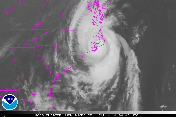


Some recent satellite and radar history of Arthur:
Jul 3, 2014
Hurricane Arthur


Jun 17, 2014
Stanton and Pilger NE Storm
Yesterday, we tracked the storm that hit Stanton and Pilger, NE with a strong tornado, from Pender, NE to Sioux City, IA.
There were multiple funnel clouds seen from 1 mile east of Pender on Route 94. This video is from 4:55-5:01 PM CDT on June 16, 2014:
There was good storm stucture a few miles north of Pender, NE on Route 9. This video runs from 5:10-5:12 CDT:
We saw two funnel clouds simultaneously between Pender and Emerson, NE on Route 9. The video runs from 5:13-5:17 PM CDT:
We found ourselves too close to rapid rotation while driving east on Route 35 just northeast of Emerson, NE. The video runs from 5:26-5:28 PM CDT:
There were rapidly rotating funnel clouds just southwest of Hubbard, NE on Route 35. The video runs from 5:32-5:35 PM CDT:
We saw great striations on Route 35 between Hubbard and Dakota City, NE. The video runs from 5:41-5:42 PM CDT:
We saw incredible storm structure on Route 35 between Hubbard and Dakota City, NE. The video is at 5:43 PM CDT:
The supercell had rapid rotation on Route 35 between Hubbard and Dakota City, NE. The video runs from 5:45-5:47 PM CDT:
The tilted updraft was visible from US 75/77 just north of Dakota City, NE as the storm began to weaken. This is from 5:53-5:54 PM CDT:
There were multiple funnel clouds seen from 1 mile east of Pender on Route 94. This video is from 4:55-5:01 PM CDT on June 16, 2014:
Jun 12, 2014
Hurricane Christina

Christina is already the second category 4 hurricane in the East Pacific this season. This is the earliest in the season that two hurricanes reached category 4 in the East Pacific since 1966 when satellite monitoring began.
Jun 2, 2014


Subscribe to:
Posts (Atom)