The HMON, HWRF, GFS, GDPS, ECMWF, GEFS, CMCE and EPS all indicate Hurricane Dorian will landfall somewhere in central or southern Florida. Landfall is most likely Monday night of Tuesday morning (Sept 2nd or 3rd). Dorian may slow as it approaches Florida, which could prolong the impact of wind and storm surge, and increase the risk of flooding. Though it's still early, the models are now generally putting Dorian's track near West Palm Beach or Port St. Lucie.
Dorain is currently a category 2 hurricane with wind estimated at 105 mph. Dorian will be entering an area with light shear and water temperatures in the mid 80s. This should allow Dorian to strengthen to category 4.
Showing posts with label tropics. Show all posts
Showing posts with label tropics. Show all posts
Aug 30, 2019


Oct 1, 2016
Hurricane Matthew

Matthew is the first category 5 hurricane in the Atlantic in over 9 years. The last category 5 was Hurricane Felix in September of 2007. Felix made landfall in Nicaragua. The US hasn't been hit by a major hurricane since Wilma in 2005.
Matthew is located south of Haiti and moving westward. It will soon begin curving to the north as it moves toward an upper trough. Matthew will likely pass near Jamaica, and cross Cuba and move into the Bahamas. It's too early to tell if Matthew poses a threat to the US East Coast. It may depend in part on the behavior of a larger trough currently over the West Coast.
Oct 23, 2015
Hurricane Patricia Landfall

Update: NHC has indicated that at the time of landfall minimum pressure was 920 mb, and wind was 165 mph.
Hurricane Patricia

Hurricane Patricia should make landfall near Puerto Vallarta tonight. In addition to catastrophic storm surge and wind damage, flash flooding and mudslides will be a major problem, because Patricia will be moving directly into mountainous terrain.
Oct 3, 2015
Hurricane Joaquin Strengthens

At 12:00 PM EDT, data from a Hurricane Hunter plane prompted the NHC to increase the intensity of Joaquin to 135 knots (155 mph), and drop the minimum central pressure to 933 mb. Joaquin is expected to miss the US, but there is still some chance for it to pass close to Nova Scotia. Joaquin is moving north into areas with increasing shear and should not strengthen any further.
As tropical moisture, some of which is associated with Joaquin, has been forced into a front along the East Coast, over 14" was reported near Wilmington, NC over the last 2 days.
Oct 1, 2015
Hurricane Joaquin


Depth of the 26C isotherm

Aug 29, 2015
Pacific Hurricanes

Sep 16, 2014
Hurricane Edouard
Hurricane Edouard reached category 3 intensity today at 1500Z. Winds are estimated to be 100 knots (115 mph), and pressure 955 mb. Edouard is passing to the east of Bermuda (far left in the image below), and has no chance of landfall.
 Edouard is the first Atlantic hurricane to reach category 3 strength since Sandy did on October 25th, 2012.
Aug 2, 2014
Super Typhoon Halong

Jul 4, 2014
Hurricane Arthur Update
Hurricane Arthur has strengthened to category 2 with wind at 85 knots (100 mph) and a central pressure of 973 mb. Winds have gusted to 73 knots (84 mph) at Cape Lookout, NC and to 79.1 knots (89.9 mph) at Hatteras, NC. Station 41036 (south of Morehead City) has reported 28.9 foot waves. Hurricane Arthur is beginning to accelerate to the northeast and will impact New England and Nova Scotia tomorrow.
Some recent satellite and radar history of Arthur:


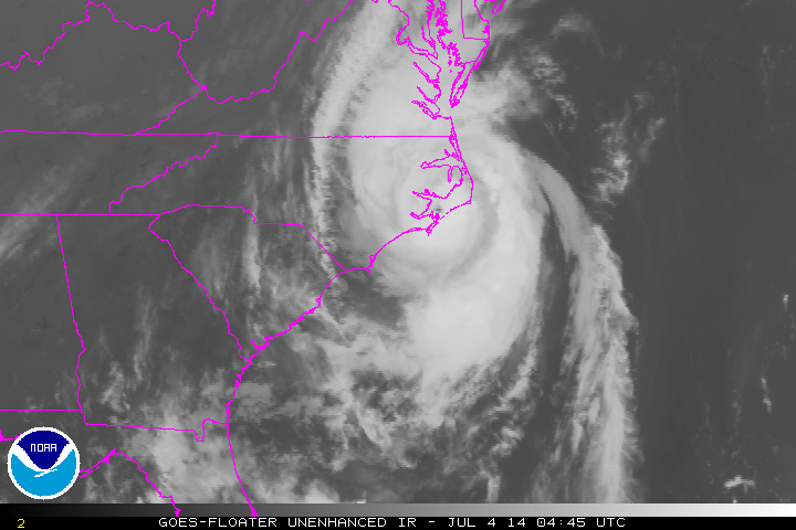


Some recent satellite and radar history of Arthur:
Jul 3, 2014
Hurricane Arthur


Jun 12, 2014
Hurricane Christina

Christina is already the second category 4 hurricane in the East Pacific this season. This is the earliest in the season that two hurricanes reached category 4 in the East Pacific since 1966 when satellite monitoring began.
Nov 18, 2013
Illinois Tornadoes November 17 2013
I managed to get some spectacular video of the EF-4 tornado that hit Washington, IL:
This video begins at 11:23 AM CST from 1 mile west of Benson, IL in Woodford County, at the junction of route 116 and 117. We are about 20 east-northeast of Peoria.
Damage along I-39:
Radar imagery shows a classic hook and a 70+ knot rotational couplet (delta v probably around 150 knots):




This video begins at 11:23 AM CST from 1 mile west of Benson, IL in Woodford County, at the junction of route 116 and 117. We are about 20 east-northeast of Peoria.
Damage along I-39:
Radar imagery shows a classic hook and a 70+ knot rotational couplet (delta v probably around 150 knots):


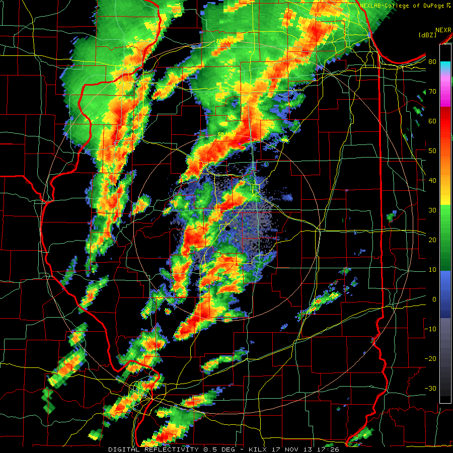


This tornado formed in an area with 1,000-1,500 CAPE, 400-500 helicity, 62-64 dew points, 50+ knot low level jet, and an impressive 500 mb left exit region. The tornado developed at 1705Z and passed about 1/3 of the way from Lincoln (sounding at 16Z) to Davenport (sounding at 14Z):


Storm reports from the 17th:

The NHC has named a storm in the Central Atlantic Melissa, but it does not appear to be tropical in nature. It is on the lower right.


Nov 14, 2012
Sandy Update and Winter Storms
The death toll from Sandy in the US and Canada has risen to 121, and damage is estimated at $50 billion. Over 8.1 million customers lost power, 2.5 million of which were in New Jersey, amounting to 62% of the state total. A total of 20,000 flights were cancelled. Aerial before and after photos of the damage Sandy caused are available here.
Nine days after Sandy made landfall, this nor'easter hit Fairhaven, MA with 65 mph wind, and Clintonville, CT with 13.5" of snow:

 This same nor'easter brought cold air down across the East Coast which later prompted frost advisories (blue) for the morning of November 9th as far south Florida, including Gainesville and Ocala:
 The blizzard warnings (red) in the image above in Montana are from a storm that hit Crosby, North Dakota with 18" of snow on November 10th, and prompted a freeze warning for Tucson, AZ for the morning of November 12th:

 On the morning of the 12th, the low temperature at Tucson was 35, and a record low of 22 was set at Douglas, AZ.
Nine days after Sandy made landfall, this nor'easter hit Fairhaven, MA with 65 mph wind, and Clintonville, CT with 13.5" of snow:


Subscribe to:
Posts (Atom)