Showing posts with label cold. Show all posts

Apr 17, 2018

April Snowstorm

A very late season snowstorm produced up to 33" of snow in central Wisconsin from April 13-15.
Some snow totals:

14.3" Sioux Falls, SD
15.8" Minneapolis - St Paul
24.2" Green Bay, WI
21.2" Appleton, WI
28.0" Stevens Point, WI
31.6" Carlsville, WI (Door County)
33.0" Amherst, WI (Portage County)

At Green Bay, the 24.2" that they received was the largest April snowstorm on record. The previous record was only 11.0" on April 4 - 5 in 1977. Incredibly, it was the 2nd largest snowstorm on record. The largest had been 29.0" on March 1 -2 1888. There have been numerous roof collapses in the Green Bay Area. Green Bay has had 36.7" of snow in just April alone. The previous snowiest April was just 15.1" in 1907.

The first half of April has been up to 16F below normal for the Midwest:
NWS Des Moines reports that temperatures for the April 1 - 15 period have been 11.5 - 16.0F below normal, and the coldest since 1881:

Estherville, Mason City, Waterloo, Ottumwa and Lamoni currently 
rank as the coldest start to April on record /April 1-15/. Des 
Moines is currently 2nd coldest, behind 1881, as it is the only of
the sites with records dating back that far.

Jan 12, 2018

First Week of January

The first week of January was more than 20F below normal from Illinois to West Virginia.

Mar 2, 2015

Winter Temperatures

The winter of 2014-2015 has been a temperature roller coaster, particularly for the Midwest. November was already winter-like, with a large part of the Midwest 7F below normal:
Almost the entire contiguous 48 was above normal in December:
January was cold in the east and south:
Persistent eastern troughing produced temperatures 11 - 14F below normal for most of the Great Lakes and Northeast in February:

Feb 21, 2015

Florida Freeze

On February 19th, arctic air moved into the eastern US:
Hard freeze warnings went to Daytona Beach, freeze warnings went to near West Palm Beach, and a wind chill advisory was issued for Miami:
Numerous low temperature records were set on Feb 20th, and many by a wide margin:
                              new       old
Location               record   record    year
Marquette                -26       -15     1966
Detroit                     -12       -8       1934
Cincinnati                -12      -7        1885
Pittsburgh                 -10      -2       1968
NYC Central Park       2          7       1950
Washington DC          5          8       1896
Charleston                18       22      1968
Macon                      18       21      1958
Jacksonville              24       28      1958
Vero Beach               30       35      1958
West Palm Beach      38       42      1958
Naples                      36       39      1960
Key West                  49       52      1958

The low of -10 at Pittsburgh was the lowest temperature this late in the season since records began in 1871.

Nov 27, 2014

Thanksgiving Snowstorm

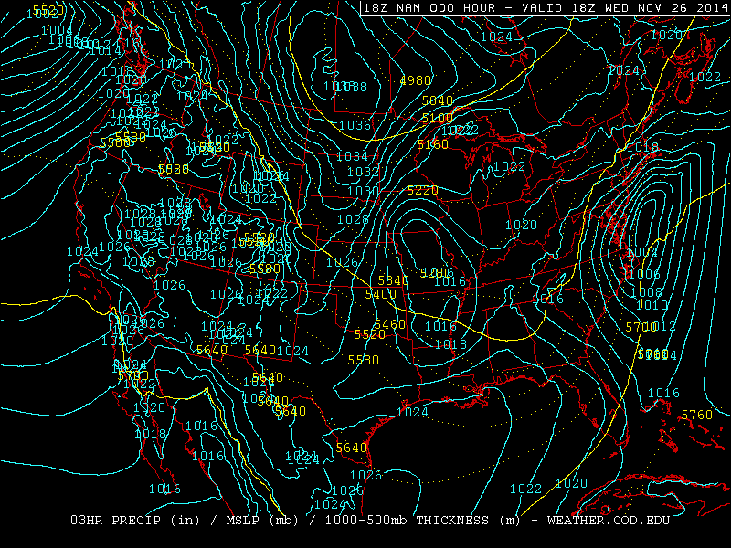
Yesterday (Nov 26, day before Thanksgiving), a Nor'Easter hit Massachusetts with 15" of snow (Savoy) and West Virginia with 20" (Paw Paw). One interesting feature of this storm was that because of an isothermal layer from 700-550 mb seen in the Albany, NY sounding, heavy snow fell over 100 miles south of the 540 line.


With temperatures at or above -10C up to the 550 mb level, heavy wet snow fell and caused over 350,000 power outages.

This storm pushed polar air deep into the Gulf of Mexico. At station 42002, 207 nautical miles east of Brownsville, TX the dew point dropped into the mid 30s:

Nov 26, 2014

Siberian Cold

Temperatures in Siberia have already dropped to -61 F (-52 C). A Russian plane that was stuck because the wheels were frozen to the ground was pushed by the passengers. 850 temps are well below normal in Siberia for this time of year:
For comparison, here is the same chart from the same time last year:

Nov 25, 2014

Record Cold And Snow In Chicago

From November 12th to the 18th, there were 180 consecutive hours below freezing - a new record for November. The old record was 172 hours November 24th to 30th in 1903. There were eight consecutive days with at least a trace of snow From November 12th to 18th. This is the earliest this has been recorded for Chicago. The old record was from November 13 to 20th 1937.

Nov 19, 2014

Record Cold In Florida

Low temperatures from this morning include:
31 at New Orleans
23 at Mobile
25 at Pensacola (new record, old record 28 in 1903)
22 at Tallahassee (new record, old record 25 in 2008)
27 at Jacksonville (new record, old record 28 in 2008)
41 at Tampa

Nov 18, 2014

Hard Freeze Warning In Florida

A hard freeze warning is in effect for tonight for most of northern Florida, including Ocala. Orlando is under a wind chill advisory (light blue):
Yesterday morning's (Nov 17) lows included 23 at Dallas and 37 at Corpus Christi. This morning it was 24 in Atlanta and 27 at Mobile Regional Airport. This air mass is moving into Florida now:

Nov 14, 2014

Gulf Coast Freeze

This morning, Nov 14, the low temperature at downtown Mobile and Pensacola was 32. Similar temps are expected again tonight. All models indicate that the next surge of arctic air on Tuesday will be even colder.

Jordan, MT had a low of -26 this morning. Casper, WY was -27 the night of Nov 14.

Nov 1, 2014

Halloween Storm

Yesterday, accumulating snow fell from the Great Lakes to the Southern Appalachians:
A 69 mph wind gust was measured at Gary Airport in Indiana. The South Lake Michigan Buoy recorded a 51 knot (59mph) gust, which is the second highest since 1981. It also reported a tie for the second highest wave height - 21.7 feet.

This morning (Nov 1), freezing temperatures occurred across Oklahoma, Arkansas, and Northern Mississippi. Tonight, the freeze may reach the Florida Panhandle:

Oct 30, 2014

Winter Conditions For Great Lakes On Halloween

A potent storm system is expected move from Manitoba to the Southeast US over the next three days. By Friday evening, 850 temps as cold as -10C are forecast reach the south Lake Michigan buoy, where the water temperature is currently 53F:
This would result in a lake-850 delta t of over 20C, which could produce thunder snow for Halloween in Wisconsin, Michigan, Northwest Indiana and Chicago. In addition, with temperatures dropping into the upper 30s combined with 30 mph winds with gusts near 50, wind chill values may be as low as 20, along with blowing snow. Winds will be even stronger over the Lakes, resulting in waves over 20 feet. A storm warning has just been issued for southern Lake Michigan, and a lakeshore flood advisory has been issued for Chicago, Northwest Indiana and Southwest Michigan.

Significant snow accumulations are likely in the Central and Southern Appalachians on Halloween. Freezing temperatures may reach Oklahoma and Tennessee by Saturday morning.

Jul 29, 2014

Cold Waters and High Waves on the Great Lakes

Today station 45004 on Lake Superior is still reporting water temperature of just 38F. The normal for late July is in the mid 50s.

On Lake Michigan, 33 knot north winds produced 11.4 foot waves at the Michigan City, IN buoy yesterday morning. The large waves produced enough upwelling to drop the water temperature to 58.8 F at the southern Lake Michigan buoy. Water temperatures were around 61 before the big waves hit, which is already about 10 degrees below normal.

Jul 10, 2014

July Cold

Cold air has spread across northern Wisconsin this morning. Rhinelander had a low temperature of 41, Eagle River 38, and Land O' Lakes 37. Temperatures will likely drop into the 40s in Iowa and Illinois by Monday night (July 14).

Apr 22, 2014

Winter Continues In The Great Lakes

It has now been over a month since the vernal equinox, and the Great Lakes are still 39.9% ice covered:
Most of the Great Lakes area was over 8 degrees F below normal in March and slightly below normal so far in April:

In Michigan, Detroit and Flint have now had the snowiest season on record. On April 15th, Detroit had 3.2" of snow, putting the total for the 2013-2014 season at 94.9". The previous record of 93.6" goes all the way back to the 1880-1881 season.

Mar 27, 2014

Great Lakes Ice Cover Update

Yesterday (March 26) the Great Lakes were still 74.3% ice covered:
At this time last year, the Great Lakes were almost ice free:
Even after the cold winter of 2011, only Lake Eerie had significant ice:
The last time ice cover was anything close to this year was 2009:
Ice covered about the same areas in 2009 as this year, but ice concentration was lower in 2009.

Temperatures have been 8 to 12 degrees below normal across the Great Lakes during the last 30 days:

Mar 2, 2014

Winter Storm Today and Continuing Brutal Winter

A major winter storm is underway today from the Southern Plains to the Ohio Valley. Winter storm warnings were issued from Kansas and Oklahoma to New Jersey, and wind chill warnings were issued across the Northern Plains as another arctic air mass comes in:


The arctic air undercut warm, moist air in the Southern Plains today, resulting in temperature inversions over 20C in the 900-800 mb layer as seen in the Norman, Oklahoma sounding this morning:


This strong temperature inversion has allowed heavy freezing rain to fall in very cold temperatures. For example, Mountain Home, AR is now (9 PM CST) reporting freezing rain with a temperature of 14.

This same storm hit California (now suffering an exceptional drought) with 4 feet of high elevation snow (Volcanic Knob), 12.44" of rain at Greenfield, 4.09" of rain at Los Angeles - USC, a 91 mph wind gust at Mount Wilson, and a 102 mph wind gust at Big Bear Lake.

This has been an extremely cold winter with repeated arctic outbreaks for the eastern two-thirds of the US. Temperatures have been as much as 9 degrees below normal in the Upper Mississippi Valley during meteorological winter (Dec thru Feb), and 12 degrees below normal for February:

Chicago has had the third coldest and third snowiest meteorological winter on record. The Great Lakes are now almost completely ice covered:

Feb 6, 2014

Brutal Winter of 2014 Update

On February 4th, this storm prompted winter storm warnings from the Southern Plains to the Northeast:

This storm produced 2" of sleet at Cape Girardeau, IN, 0.33" of freezing rain at Northeast Philadelphia, and 0.25" of freezing rain at Central Park, NY. 0.50" ice of accumulated at South Ozone Park, Queens, NY; Wilson, AR; Atoka, TN; Martin, TN; Manchester, MD; Metuchen, NJ; and 0.75" of ice accumulated at Marion, KY.

Snowfall amounts include 11.5" at Hutchinson, KS; 13.2" at Topeka, KS; 15.5" at Eskridge, KS; 15" at Sayre, PA; 11.4" at Montague, NJ; 15" at Bainbridge, NY; 12.5" at Torrington, CT; 10.6" at Boston Logan, and 13.2" at Lunenburg, MA. At Chicago, the 7" of snow from this storm pushed the seasonal total to 59.6", already making it the 8th snowiest season since 1884, and the 3rd snowiest up to February 5th.

Also on February 4th, a 944 mb storm hit the British Isles, this time further south than previous storms from this season had:

Yesterday morning (Feb 5), the temperature at Denver dropped to -19. A record low maximum temperature of -1 was set on February 5th.

So far this winter, Waco, TX has had a record setting 53 freezes.

Starting in November, and continuing through January, temperatures have been far below normal for the Midwest, and below normal for almost the entire eastern two-thirds of the US:
In Siberia, temperatures were as low as -73 at Ojmjakon on February 1, and at Verhojansk on February 3 and 4.

Jan 30, 2014

Gulf Coast Winter Storm 2

On January 28th and 29th, unusually cold air spread across the Gulf Coast:
Snow accumulated along the Gulf Coast from Louisiana to Florida:

With chinook winds in place across the Plains, this led to the strange situation of having no snow cover in Nebraska, and having snow cover in Florida. New Orleans received freezing rain. Freezing rain accumulated 0.1" at Mobile, AL; 0.25" at Gulf Breeze, FL (near Pensacola); 0.25" at Fort Walton Beach, FL; 0.5" at Sylvania, GA; and 0.75" at Summerton, SC. Sleet accumulations include 0.75" at Alexandria, LA; 0.9" at Kenrwood, LA; 2" at Tylertown, MS; 1.25" at Grove Hill, AL; 0.8" at Mobile, AL; and 2.3" at Newport, NC. Heavy snow fell right along the Atlantic Coast, for example 9.8" at Virginia Beach, VA.

A hard freeze warning is active this morning (Jan 30) across the Gulf Coast:
Temperatures this morning have dropped to 25 at New Orleans, 16 at Mobile, and 22 at Pensacola.

Jan 27, 2014

Another Arctic Outbreak

Yet another arctic air mass is moving through the Midwest:
The clipper system on the leading edge of the arctic air prompted blizzard warnings from the Dakotas to Iowa:
Wind chill warnings were extended into Ohio:
Winter storm warnings have been issued along the Gulf Coast as NAM predicts a variety of frozen precipitation on Tuesday, January 28:
An impressive 949 mb storm hit the British Isles yesterday (January 26):