Showing posts with label severe. Show all posts

May 2, 2017

Texas Snow and Tornadoes


On April 29th, six tornadoes hit eastern Texas, including an EF4, an EF3, an EF2, and three EF0s. Four fatalities were confirmed.


The April 29th 12Z (7 AM CDT) sounding for Fort Worth showed that there was already 2,500 CAPE:
As dew points rose into the mid 70s in the afternoon east of Dallas, CAPE values exceeded 5,000 by 21Z (4PM CDT) according to NAM:
There was strong low level wind - greater than 40 knots at the 1 km level - and a clockwise turning wind field with height, producing sufficient shear and helicity for tornadoes.
On April 29 and 30, heavy snow fell across the High Plains as far south as the Texas Panhandle. Amarillo received 3" and Dalhart had 9". There were over 50,000 power outages in the Texas Panhandle caused by high winds. At Amarillo, winds gusted to 54 mph and visibility dropped to 1/2 mile.

Garden City, KS had blizzard conditions on the 30th and 11" of snow, causing three structures to collapse. 14" fell in the southwest corner of Kansas at Elkhart. One farmer near Sublette estimated that he had lost 80% of his crop. At Wallace in northwest Kansas, 28" of snow fell, with drifts of 8-10 feet. 33" fell at Lander, WY and 39" fell at San Isabel, CO.

Flooding has killed 7 in Arkansas and 3 in Missouri. In southern Missouri, the town of Houston received 11.15" of rain.

Dec 29, 2015

Central US Winter Storm

Over the past several days (Dec 26 - Dec 28) a major winter storm hit the central US. Winter storm warnings stretched almost from the Canadian Border to the Mexican border:
Blizzard warnings were issued for west Texas, where up to two feet of snow fell (Queen). At Lubbock, 11" of snow fell, a state of emergency was declared, and a roof collapsed at a mall. Sleet accumulated to 3.4" at Rockford, IL and 4.8" at Springville, IA. 1" of freezing rain fell at Anthony Kansas and Kewanee, IL, but some areas had problems with just 0.25" of ice because of the strong winds: in the Peoria area 70,000 customers lost power, and a gas line was ruptured.

In Missouri, flooding closed parts of I-70 and I-44. 12.25" of rain fell at Union, MO, causing record flooding. At Springfield, MO the 6.03" that fell on December 26th was the second highest 24 hour total on record. The storm total there was exactly 10.00". At least 13 flood related fatalities occurred across Missouri.

On December 26th, tornadoes killed 11 in Texas. 8 of the fatalities were from an EF-4 that hit Garland, TX:

May 15, 2014

Nebraska Tornadoes and Snow

The same storm which produced tornadoes in eastern Nebraska, also produced heavy snow in western Nebraska:


5" of snow fell at Scottsbluff (2.7 WNW), 1" fell in northwest Kansas (Kanorado), and 43" fell in Wyoming (Encampment 19 WSW).

Here is a radar review from the Hastings and Omaha Radar sites. York received 7.07" of rain from these storms and from some earlier that day.


We followed the main supercell from south of York to slightly East of Omaha. Here is some of what we saw

A huge inflow band seen from Rd 4, 1 mile west of McCool, or 9 miles south of York, NE at 4:30 PM CDT:

There was flying debris with an intense RFD near Cordova. This was on Route 76A between Cordova, NE and Highway US 6 from 5:05-5:08 PM CDT. A funnel may be visible at 1:33.

It became a large high-precipitation supercell by the time it passed near Linlocln. This was shot from near Omaha along I-680 at 72nd street from 7:25-7:29 PM CDT:

Now we are on I-680 just west of where it joins I-80 in Iowa or 3 miles north of Neola, IA at 8:02 PM CDT:

Feb 21, 2014

February 20 Tornadoes and Forecast Verification

The storm reports graphic from SPC shows that most of the tornado reports were along the northern edge of the area I outlined yesterday. This was an area with limited instability, but intense lifting and helicity. A rapid refresh sounding for central Illinois near Springfield has only around 700 MLCAPE, but helicity over 800 m2/s2:
If it had been realized in the near storm environment, it may have been significant that SBCAPE was more than double the MLCAPE value:
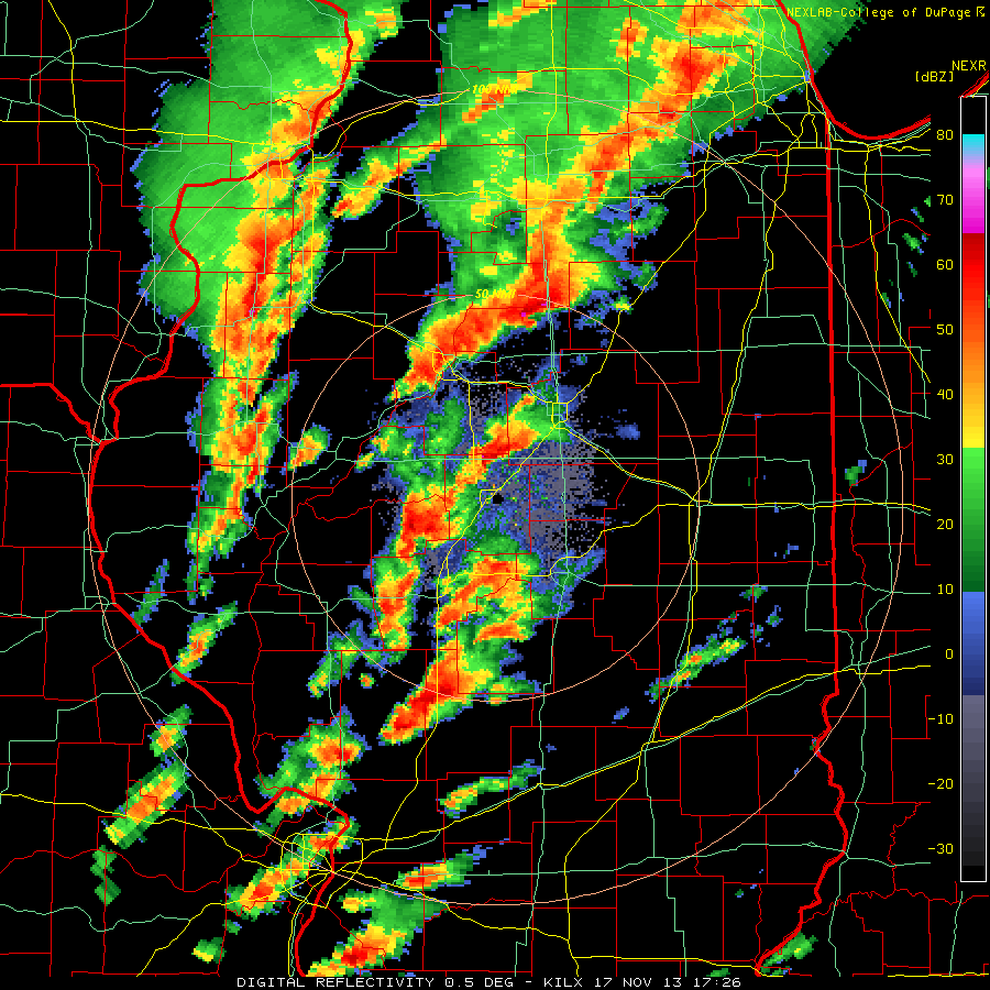
The only tornado report in my moderate risk area was from a storm in far southern Illinois that hit Carbondale with 1 inch hail, and later went across I-64. This storm was actually the most interesting on radar, which may suggest it was producing tornadoes that nobody observed:

Further south, limiting factors for tornado development included clouds and rain during peak heating hours, and winds that were backing with height in the 850 to 600 mb layer, as seen on the Nashville sounding, but not so much at Little Rock:

Winds backing with height tends to reduce storm relative helicity encourage lines instead of discrete cells.

I made a 9 day forecast for this event which was one day late, and around 400 miles to the southwest.

Dew points were generally mid 50s in central Illinois to around 60 in southern Illinois.Here are some rapid refresh analysis charts from 12Z:


The same storm that produced tornadoes also prompted blizzard warnings from southern Minnesota to central Iowa. 10.5" of snow fell in north-central Iowa.

Jan 15, 2014

Washington Tornado Radar HD

A radar review of the Washington, IL tornado outbreak from November 17th, 2013:

Dec 24, 2013

Late December Winter Storm

From December 21-23, this storm produced 15.5" of snow at Larned, KS, 25.2 " of snow at Ashland, WI, 1.25" of freezing rain in New York (Canton, Potsdam, Rensselaer Falls), and 10.24" of rain at Williams, IN:
Tornadoes and widespread wind damage occurred on December 21st:
3 fatalities were reported. One from an EF-2 in Arkansas, another from an EF-2 in Mississippi, and one from wind in Mississippi. All three were in mobile homes.

Last night, temperatures as cold as -20 occurred as far south as Dubuque, Iowa.

Nov 28, 2013

November Winter Storm

This storm prompted winter storm warnings and produced accumulating snow in central Texas as early as November 24th:


By November 26th, heavy snow fell through the Ohio Valley, while a tornado watch was issued for the Carolinas, and a freeze warning for New Orleans:

An EF-2 tornado hit Atlantic Beach, NC. On the morning of the 28th, a low temperature of 32 was observed at the New Orleans Naval Air Station. This storm also produced 41" of snow at Abajao, UT, 5.20" of rain at Mount Lemmon, AZ, 11.4" of snow at Flagstaff, AZ, and 2" of freezing rain at Odessa, TX.

Nov 21, 2013

November 17 Tornado Damage Tracks

Some tornado tracks from the November 17th outbreak:


The EF-4 Washington tornado killed 1 and injured 125. The NWS in St. Louis has indicated that EF-4 damage occurred a few miles southwest of New Minden where there were an additional 2 fatalities.

Nov 18, 2013

Illinois Tornadoes November 17 2013

I managed to get some spectacular video of the EF-4 tornado that hit Washington, IL:

This video begins at 11:23 AM CST from 1 mile west of Benson, IL in Woodford County, at the junction of route 116 and 117. We are about 20 east-northeast of Peoria.

Damage along I-39:

Radar imagery shows a classic hook and a 70+ knot rotational couplet (delta v probably around 150 knots):


This tornado formed in an area with 1,000-1,500 CAPE, 400-500 helicity, 62-64 dew points, 50+ knot low level jet, and an impressive 500 mb left exit region. The tornado developed at 1705Z and passed about 1/3 of the way from Lincoln (sounding at 16Z) to Davenport (sounding at 14Z):


Storm reports from the 17th:
The NHC has named a storm in the Central Atlantic Melissa, but it does not appear to be tropical in nature. It is on the lower right.