Over the past several days (Dec 26 - Dec 28) a major winter storm hit the central US. Winter storm warnings stretched almost from the Canadian Border to the Mexican border:
Blizzard warnings were issued for west Texas, where up to two feet of snow fell (Queen). At Lubbock, 11" of snow fell, a state of emergency was declared, and a roof collapsed at a mall. Sleet accumulated to 3.4" at Rockford, IL and 4.8" at Springville, IA. 1" of freezing rain fell at Anthony Kansas and Kewanee, IL, but some areas had problems with just 0.25" of ice because of the strong winds: in the Peoria area 70,000 customers lost power, and a gas line was ruptured.
In Missouri, flooding closed parts of I-70 and I-44. 12.25" of rain fell at Union, MO, causing record flooding. At Springfield, MO the 6.03" that fell on December 26th was the second highest 24 hour total on record. The storm total there was exactly 10.00". At least 13 flood related fatalities occurred across Missouri.
On December 26th, tornadoes killed 11 in Texas. 8 of the fatalities were from an EF-4 that hit Garland, TX:
Showing posts with label rain. Show all posts
Dec 29, 2015
Oct 3, 2015
Hurricane Joaquin Strengthens
At 12:00 PM EDT, data from a Hurricane Hunter plane prompted the NHC to increase the intensity of Joaquin to 135 knots (155 mph), and drop the minimum central pressure to 933 mb. Joaquin is expected to miss the US, but there is still some chance for it to pass close to Nova Scotia. Joaquin is moving north into areas with increasing shear and should not strengthen any further.
As tropical moisture, some of which is associated with Joaquin, has been forced into a front along the East Coast, over 14" was reported near Wilmington, NC over the last 2 days.
Oct 1, 2015
Hurricane Joaquin
Hurricane Joaquin has encountered water temperatures around 85F, and decreasing shear as it moves into the Bahamas. This has led to Joaquin strengthening from 70 knots to 110 knots over the last 24 hours. A trough over the southeast US should begin to turn Joaquin to the north within 24 hours. Ridging is forecast to develop over New England by Saturday, Oct 3. Although the models are still split, it is possible that the ridge will turn Joaquin westward and into the East Coast. This is a pattern similar to the one for Hurricane Sandy. Right now, models indicate that landfall may occur anywhere from South Carolina up to Newfoundland.
As Joaquin moves north, it will remain in water that is at least 80F until it moves north of Cape Hatteras. The depth of warm water will be sufficient to sustain a major hurricane as well:
Even if Joaquin does not landfall, tropical moisture will be absorbed into the southeast US trough and produce flooding across the East Coast region:
Depth of the 26C isotherm
Dec 13, 2014
West Coast Storm
A storm which affected the West Coast from Wednesday, Dec 10 through Friday, Dec 12 hit California with 14.48" of rain (Whiskeytown), 19.8" of snow (Lodgepole), and a 139 mph wind gust (Benton). Numerous other locations reported very heavy rainfall and 100+ mph winds. From the Weather Prediction Center's storm summary:
...SELECTED STORM TOTAL RAINFALL IN INCHES FROM 900 AM PST WED DEC 10 THROUGH 600 PM PST FRI DEC 12... ...CALIFORNIA... WHISKEYTOWN 1 SSW 14.48 LAKESHORE SHASTA CO 11.24 HAWKEYE 11.22 BOGGS MOUNTAIN RAWS 10.24 PESCADERO 9.70 GIRARD 9.64 MT. SAINT HELENA 9.06 BOULDER CREEK 9 WNW 8.89 SHASTA DAM 8.88 WHISPERING PINES 8.76 MINERAL 8.47 BIG SUR RAWS 8.31 STIRLING CITY 8.27 YORKVILLE 7.52 SAN MARCOS PASS 5.23 LOS PRIETOS 4.31 SAN FRANCISCO 2 SSW 4.28 LYTLE CREEK RAWS 3.93 ORO GRANDE 3.73 MONTERY NWS 3.54 LAKE ARROWHEAD NW 3.49 SAN FRANCISCO DOWNTOWN 3.46 PASADENA 3.43 SAN JOSE ARPT 3.39 SACRAMENTO 2 SE 3.33 OAKLAND ARPT 3.22 SANTIAGO PEAK 3.00 BEVERLY HILLS 1.91 LA DOWNTOWN 1.58 SANTA ANA 1.58 ...OREGON... GOLD BEACH 2.78 SELMA 5 NNE 2.53 OBRIEN 2 SSW 2.14 MERLIN 2 W 2.11 LEES CAMP 1.90 FLORENCE 2 NW 1.45 HASKINS DAM 1.20 DALLAS 1.11 ...SELECTED STORM TOTAL SNOWFALL IN INCHES FROM 900 AM PST WED DEC 10 THROUGH 600 PM PST FRI DEC 12... ...CALIFORNIA... LODGEPOLE 9 N 19.8 DONNER SUMMIT 19.0 SODA SPRINGS 3 ENE 19.0 CARSON PASS 16.0 SQUAW VALLEY 16.0 BLUE CANYON 14.8 ALPINE MEADOWS 14.0 DEVILS POSTPILE 7 NNW 14.0 KINGVALE 13.0 KIRKWOOD MEADOWS 1 SE 13.0 LAKE WISHON 4 ENE 10.5 MANZANIA LAKE 1 WNW 10.0 KINGVALE 1 W 9.0 BIG BEAR RESORT 8.0 FAWNSKIN 6.5 BASS LAKE 11 E 5.8 TWAIN 6 S 4.0 FLORENCE LAKE 7 WNW 3.0 OAKHURST 8 N 2.5 YOSEMITE VALLEY 1 NNE 0.7 ...SELECTED PEAK WIND GUSTS IN MILES PER HOUR EARLIER IN THE EVENT... ...CALIFORNIA... SODA SPRINGS 4 SE 135 WHITE MOUNTAIN PEAK NE 113 INCLINE VILLAGE 6 NE 112 MAMMOTH LAKES 3 W 111 ALPINE MEADOWS 1 SW 109 GRAPEVINE 3 SSE 105 SIERRAVILLE 5 SSE 74 KEENE 7 SW 71 MT. DIABLO 68 WOODACRE 63 GASQUET 12 SE 62 WEITCHPEC 11 WSW 60 PETROLIA 4 S 58 CRESCENT CITY 1 ESE 53 KNEELAND 50 ...NEVADA... BENTON 4 E 139 BLUE EAGLE RANCH 11 SSE 96 GARDNERVILLE 5 WSW 93 GALENA E 82 GREAT BASIN NATION 3 WNW 78 CARSON CITY 3 ENE 76 RENO 4 SE 70 SPANISH SPRINGS AIR 3 W 66 VERDI 4 E 63 EUREKA AIRPORT 60 ...OREGON... RUCH 12 S 117 SQUAW PEAK 117 CAYUSE 1 WNW 95 MILTON-FREEWATER 11 ENE 91 MT HEBO 90 MT. HEBO 90 PORT ORFORD 5 SE 90 TILLAMOOK 15 ESE 90 SEA LION CAVES 89 MARYS PEAK 88 BROOKINGS 1 SE 81 NEWPORT SOUTH JETTY 79 KOOSKOOSKIE 3 WSW 78 SPRAGUE RIVER 12 NNW 76 PENDLETON 10 SE 75 SUTHERLIN 7 ESE 75 YACHAT NNW 75 ASHLAND 1 ENE 74 PORTLAND ARPT 67 ...WASHINGTON... NASELLE 77 PORT TOWNSEND 3 E 70 DIXIE 64 WALLA WALLA 63 CAMANO 2 SSE 61 WAITSBURG 61 FREELAND 2 SSE 59 PORT TOWNSEND 1 SE 59 MCCHORD AFB 58 BANKS 56 VANCOUVER LAKE 2 NNE 55
At Buoy 46015 - 15 nautical miles west of Port Orford, OR (near Medford) - wave heights reached 31.5 feet:
Waves were as high as 15.7 feet as far south as buoy 46047 - 121 nautical miles west of San Diego.
This storm knocked out power to at least 113,000 customers, produced damaging mudslides including this one at Camarillo Springs, and even produced an EF0 tornado in South Los Angeles.
Dec 24, 2013
Late December Winter Storm
From December 21-23, this storm produced 15.5" of snow at Larned, KS, 25.2 " of snow at Ashland, WI, 1.25" of freezing rain in New York (Canton, Potsdam, Rensselaer Falls), and 10.24" of rain at Williams, IN:
Tornadoes and widespread wind damage occurred on December 21st:
3 fatalities were reported. One from an EF-2 in Arkansas, another from an EF-2 in Mississippi, and one from wind in Mississippi. All three were in mobile homes.
Last night, temperatures as cold as -20 occurred as far south as Dubuque, Iowa.
Tornadoes and widespread wind damage occurred on December 21st:
3 fatalities were reported. One from an EF-2 in Arkansas, another from an EF-2 in Mississippi, and one from wind in Mississippi. All three were in mobile homes.
Last night, temperatures as cold as -20 occurred as far south as Dubuque, Iowa.
Jun 26, 2013
Chicago Area MCS
This MCS developed in northern Illinois late last night (June 25th), and produced flooding across the north suburbs of Chicago:
A CoCoRaHS station at Cary reported 6.15" at 7 AM on the 26th.
The COD storm chasers were frustrated yesterday when nothing developed in Iowa. Despite convective inhibition of only 3 on the 0Z Omaha sounding, convective initiation never occurred:
A CoCoRaHS station at Cary reported 6.15" at 7 AM on the 26th.
The COD storm chasers were frustrated yesterday when nothing developed in Iowa. Despite convective inhibition of only 3 on the 0Z Omaha sounding, convective initiation never occurred:
May 21, 2013
Snowy April and May 2013
On April 3rd, a narrow band of cold air allowed accumulating snow to fall in central Oklahoma:
On April 9th, a storm ran warm 12C air at 850 mb over cold surface air with temps near freezing:
As a result, a convective squall line moving through central Kansas produced winter conditions at ground level. At 9:00 PM CDT, Concordia was under a severe thunderstorm warning while reporting freezing rain, a temperature of 30, a north wind at 24 mph, gusting to 35, and a wind chill of 16. Salina reported light snow, fog, a temperature of 33, wind northwest at 32, gusting to 38, and a wind chill of 19. Hutchinson reported a thunderstorm with a temperature of 32, fog, wind north at 16 gusting to 36, and a wind chill of 21. Radar from 9:11 CDT:
By 10:00 PM CDT, Hutchinson was reporting hail with a temperature of 32, fog, a north wind at 26 mph gusting to 37, and a wind chill of 18. Radar from 9:54 CDT:
Roads were coated with ice as far south as the Oklahoma-Texas border. Snowfall amounts from this storm include 28.5" at Lander, WY; 24" at Harrison, NE; 30.0" at Deadwood, SD; and a record shattering 28.2" at Rapid City, SD. The previous record from a single storm in Rapid City was 18.0" on April 22, 2001. Some wind gusts from the storm in mph are: 84 at Castaic Lake, CA; 78 at Dubuque, IA; 85 at Menominee, MI.
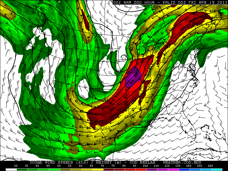
From April 16-19 this storm produced heavy snow from Colorado to Michigan:
Snowfall amounts: 20.0" at Great Basin National Park, NV; 9.5" at Denver, CO; 23.4" at Fort Collins, CO; 33.0" at Virginia Dale, CO; 36.0" at Centennial, WY; 17.3" at Cheyenne, WY; 17.7" at Duluth, MN; 8.1" at Minneapolis, MN; 22.0" at Cornucopia, WI. This storm also produced huge amounts of rain including 8.20" at Pella, IA and 7.34" at Naperville, IL.
Just a few days later, another surge of cold air allowed for snow to fall in Oklahoma and significant accumulations to occur across I-70 in Kansas:
For the morning of April 24th, a freeze warning was issued for Lubbock, TX, and a hard freeze warning for Amarillo, TX:
On April 25th, frost advisories were issued from extreme northern Texas to Tennessee:
On April 24th, low temperatures were 25 at Lubbock, and 20 at Amarillo. On the 25th, Nashville had a low of 36.
On April 26th, Fargo, ND had the latest 50 degree day on record, with the previous record being April 17th in 1881. April was the snowiest month of the 2012-2013 winter season in Fargo.
As of April 26th, the United States had the second coldest start to a spring on record.
On May 1st and 2nd, 850 temps as cold as -4C were reaching Texas:
By May 3rd, a freeze warning was issued for San Angelo, TX, and a winter weather advisory was active for northwest Arkansas:
Accumulating snow fell as far south as northeast Oklahoma and northwest Arkansas:
Up to 5" of snow fell in Arkansas. This is the first time snow has been recorded in Arkansas in the month of May. At Tulsa, OK, snow fell on May 2nd, breaking the previous latest snow on record of April 18th in 1953. Records in Tulsa go back to 1900.
Another surge of cold air prompted a frost advisory for Nashville on May 13th:
Record lows of 39 at Nashville and 33 at Crossville occurred on May 13th.
On May 14th, a blizzard hit the UK with 65 mph wind and power outages.
On April 9th, a storm ran warm 12C air at 850 mb over cold surface air with temps near freezing:
As a result, a convective squall line moving through central Kansas produced winter conditions at ground level. At 9:00 PM CDT, Concordia was under a severe thunderstorm warning while reporting freezing rain, a temperature of 30, a north wind at 24 mph, gusting to 35, and a wind chill of 16. Salina reported light snow, fog, a temperature of 33, wind northwest at 32, gusting to 38, and a wind chill of 19. Hutchinson reported a thunderstorm with a temperature of 32, fog, wind north at 16 gusting to 36, and a wind chill of 21. Radar from 9:11 CDT:
By 10:00 PM CDT, Hutchinson was reporting hail with a temperature of 32, fog, a north wind at 26 mph gusting to 37, and a wind chill of 18. Radar from 9:54 CDT:
Roads were coated with ice as far south as the Oklahoma-Texas border. Snowfall amounts from this storm include 28.5" at Lander, WY; 24" at Harrison, NE; 30.0" at Deadwood, SD; and a record shattering 28.2" at Rapid City, SD. The previous record from a single storm in Rapid City was 18.0" on April 22, 2001. Some wind gusts from the storm in mph are: 84 at Castaic Lake, CA; 78 at Dubuque, IA; 85 at Menominee, MI.
From April 16-19 this storm produced heavy snow from Colorado to Michigan:
Snowfall amounts: 20.0" at Great Basin National Park, NV; 9.5" at Denver, CO; 23.4" at Fort Collins, CO; 33.0" at Virginia Dale, CO; 36.0" at Centennial, WY; 17.3" at Cheyenne, WY; 17.7" at Duluth, MN; 8.1" at Minneapolis, MN; 22.0" at Cornucopia, WI. This storm also produced huge amounts of rain including 8.20" at Pella, IA and 7.34" at Naperville, IL.
Just a few days later, another surge of cold air allowed for snow to fall in Oklahoma and significant accumulations to occur across I-70 in Kansas:
For the morning of April 24th, a freeze warning was issued for Lubbock, TX, and a hard freeze warning for Amarillo, TX:
On April 25th, frost advisories were issued from extreme northern Texas to Tennessee:
On April 24th, low temperatures were 25 at Lubbock, and 20 at Amarillo. On the 25th, Nashville had a low of 36.
On April 26th, Fargo, ND had the latest 50 degree day on record, with the previous record being April 17th in 1881. April was the snowiest month of the 2012-2013 winter season in Fargo.
As of April 26th, the United States had the second coldest start to a spring on record.
On May 1st and 2nd, 850 temps as cold as -4C were reaching Texas:
By May 3rd, a freeze warning was issued for San Angelo, TX, and a winter weather advisory was active for northwest Arkansas:
Accumulating snow fell as far south as northeast Oklahoma and northwest Arkansas:
Up to 5" of snow fell in Arkansas. This is the first time snow has been recorded in Arkansas in the month of May. At Tulsa, OK, snow fell on May 2nd, breaking the previous latest snow on record of April 18th in 1953. Records in Tulsa go back to 1900.
Another surge of cold air prompted a frost advisory for Nashville on May 13th:
Record lows of 39 at Nashville and 33 at Crossville occurred on May 13th.
On May 14th, a blizzard hit the UK with 65 mph wind and power outages.
Apr 16, 2013
February 2013
On February 1st, a 940 mb storm was located between Labrador and Greenland:
February was very active in the US. On February 8-9, this storm dumped 40 inches of snow on Hamden, CT, and hit Cuttyhunk, MA with 83 mph wind:
In the afternoon, the storm developed an eye:
On February 10th, just one day later, another storm ejected into the Midwest and hit Aberdeen, SD with 20.8" of snow and Hattiesburg, MS with a tornado:
The tornado produced EF-4 damage just west of Hattiesburg. 82 injuries were reported, but no fatalities. After looking at some new footage of the tornado, it is amazing that nobody was killed.
On February 17th, a polar air mass spread across Florida, producing a dewpoint of 7 at Daytona Beach and a temperature of 59 at Key West even during mid afternoon:
On February 21-22, this storm produced 22 inches of snow at Russell, KS and 3 inches of sleet at Fort Scott, KS:
On February 25th, a blizzard warning (red) was issued for Lubbock, TX, and winter storm watches/warnings from New Mexico to Ohio:
Some of the highlights of this storm include 17" of snow at Amarillo, TX; 21" of snow at Follett, TX; 8.02" of rain at Valdosta, GA; and 84 mph wind at El Paso, TX.
February was very active in the US. On February 8-9, this storm dumped 40 inches of snow on Hamden, CT, and hit Cuttyhunk, MA with 83 mph wind:
On February 8th, a 70+ knot easterly low level jet forced an intense band of snow to develop over Long Island:
Snowfall rates of 3-4 inches per hour were reported, with one report of 6 inches in one hour in Central Connecticut. Islip Airport reported 27.8" of snow and Upton 30.3". Boston had 24.9" of snow and a maximum wind of 76 mph. A record 31.9" fell at Portland, ME. Over 600,000 people lost power, and over 6,000 flights were cancelled. By the morning of February 9th, the storm had dropped to 970 mb about 200 miles east of Boston:In the afternoon, the storm developed an eye:
On February 10th, just one day later, another storm ejected into the Midwest and hit Aberdeen, SD with 20.8" of snow and Hattiesburg, MS with a tornado:
The tornado produced EF-4 damage just west of Hattiesburg. 82 injuries were reported, but no fatalities. After looking at some new footage of the tornado, it is amazing that nobody was killed.
On February 21-22, this storm produced 22 inches of snow at Russell, KS and 3 inches of sleet at Fort Scott, KS:
On February 25th, a blizzard warning (red) was issued for Lubbock, TX, and winter storm watches/warnings from New Mexico to Ohio:
Some of the highlights of this storm include 17" of snow at Amarillo, TX; 21" of snow at Follett, TX; 8.02" of rain at Valdosta, GA; and 84 mph wind at El Paso, TX.
Subscribe to:
Posts (Atom)