A very late season snowstorm produced up to 33" of snow in central Wisconsin from April 13-15.
Some snow totals:
14.3" Sioux Falls, SD
15.8" Minneapolis - St Paul
24.2" Green Bay, WI
21.2" Appleton, WI
28.0" Stevens Point, WI
31.6" Carlsville, WI (Door County)
33.0" Amherst, WI (Portage County)
At Green Bay, the 24.2" that they received was the largest April snowstorm on record. The previous record was only 11.0" on April 4 - 5 in 1977. Incredibly, it was the 2nd largest snowstorm on record. The largest had been 29.0" on March 1 -2 1888. There have been numerous roof collapses in the Green Bay Area. Green Bay has had 36.7" of snow in just April alone. The previous snowiest April was just 15.1" in 1907.
The first half of April has been up to 16F below normal for the Midwest:
NWS Des Moines reports that temperatures for the April 1 - 15 period have been 11.5 - 16.0F below normal, and the coldest since 1881:
Estherville, Mason City, Waterloo, Ottumwa and Lamoni currently
rank as the coldest start to April on record /April 1-15/. Des
Moines is currently 2nd coldest, behind 1881, as it is the only of
the sites with records dating back that far.
On April 29th, six tornadoes hit eastern Texas, including an EF4, an EF3, an EF2, and three EF0s. Four fatalities were confirmed.
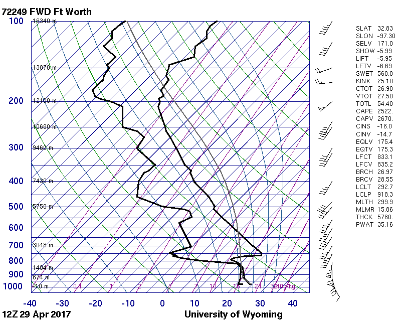
The April 29th 12Z (7 AM CDT) sounding for Fort Worth showed that there was already 2,500 CAPE:
As dew points rose into the mid 70s in the afternoon east of Dallas, CAPE values exceeded 5,000 by 21Z (4PM CDT) according to NAM:
There was strong low level wind - greater than 40 knots at the 1 km level - and a clockwise turning wind field with height, producing sufficient shear and helicity for tornadoes.
On April 29 and 30, heavy snow fell across the High Plains as far south as the Texas Panhandle. Amarillo received 3" and Dalhart had 9". There were over 50,000 power outages in the Texas Panhandle caused by high winds. At Amarillo, winds gusted to 54 mph and visibility dropped to 1/2 mile.
Garden City, KS had blizzard conditions on the 30th and 11" of snow, causing three structures to collapse. 14" fell in the southwest corner of Kansas at Elkhart. One farmer near Sublette estimated that he had lost 80% of his crop. At Wallace in northwest Kansas, 28" of snow fell, with drifts of 8-10 feet. 33" fell at Lander, WY and 39" fell at San Isabel, CO.
It's been a weird winter for Chicago. December had 17.7" of snow - all of which fell before the 18th. The 19th had low temperature of -13. But the day after Christmas had a high 54. Only 0.6" of snow fell in January. February had just a trace. The normal for January and February combined is 19.9". In mid-February, there were six days in a row with a high temp in the 66 - 70 range. Now on March 14th, Chicago just received 7.5" of snow. December had 9.5" above normal snowfall, January was 10.2" below normal, February was 9.1" below normal, and March will be 2.2" above normal even if there isn't any more snow for the rest of the month.
A major 983 mb East Coast storm (aka snowzilla) produced up to 42" of snow Friday and Saturday (Jan 23 and 24). Winter storm warnings (pink) were issued from Arkansas to South Carolina to Massachusetts. Blizzard warnings were issued from Washington DC to Long Island:
Here is a time lapse of the blizzard from Purcellville, VA:
Over the past several days (Dec 26 - Dec 28) a major winter storm hit the central US. Winter storm warnings stretched almost from the Canadian Border to the Mexican border:
Blizzard warnings were issued for west Texas, where up to two feet of snow fell (Queen). At Lubbock, 11" of snow fell, a state of emergency was declared, and a roof collapsed at a mall. Sleet accumulated to 3.4" at Rockford, IL and 4.8" at Springville, IA. 1" of freezing rain fell at Anthony Kansas and Kewanee, IL, but some areas had problems with just 0.25" of ice because of the strong winds: in the Peoria area 70,000 customers lost power, and a gas line was ruptured.
In Missouri, flooding closed parts of I-70 and I-44. 12.25" of rain fell at Union, MO, causing record flooding. At Springfield, MO the 6.03" that fell on December 26th was the second highest 24 hour total on record. The storm total there was exactly 10.00". At least 13 flood related fatalities occurred across Missouri.
On December 26th, tornadoes killed 11 in Texas. 8 of the fatalities were from an EF-4 that hit Garland, TX:
On May 8th and 9th, a mid-level jet streak emerged into the Central Plains, triggering severe weather. Here are the storms that we saw. On Friday, May 8th, we tracked a supercell along the Red River Valley. We first intercepted it at the junction of US 183 and 287 east of Vernon, TX. This video is from while we are driving east on 287 near Harold, TX from 4:50-4:58 PM CDT:
This one is while we are driving north on 1739 and then east on 240 from 5:16-5:19 PM CDT:
We followed it into far southern Oklahoma, heading east on US 70. This is from just east of Randlett from 5:50-5:53 PM CDT.
The view from the junction of US 70 and 65 was had low contrast, but there was starting to be some good lightning. This was from 6:14-6:18 PM CDT:
From 6:31-6:41 PM CDT the structure had become impressive, there was more intense lightning, and the storm was producing a constant low rumbling sound. We are on US 70 west of Waurika and south of Hastings.
One more good view from Waurika, at the intersection of US 70 and US 81 from 6:54-6:59 PM CDT:
On May 9th, we caught a storm that had recently developed in the Texas Panhandle along a dry line, and moved into the Oklahoma Panhandle. We are on US 64 about 5 miles northeast of Beaver, east of Forgan, and east of highway 23. This is from 6:35-6:36 PM CDT on May 9, 2015:
These next three are from the same spot, at 6:45-6:46, 6:48, and 7:01-7:03 PM CDT:
This one is from a little further east on US 64 from 7:15-7:17 PM CDT:
The next video is from Kansas highway 34, north of US 160, northeast of Ashland, and west of Coldwater. This was from 8:26-8:27 PM CDT:
As we continued north on 34, the storm intensified. This was from 8:29-8:37 PM CDT, and towards the end of the video, we are nearing Bucklin and US 54:
At the beginning of the next video, we are at Bucklin, on Kansas highway 34, just south of US 54 seeing excellent storm structure. We then drive east on 54, then north from Mullinville. This was from 8:38-8:58 PM CDT:
The same synoptic scale system responsible for these storms also produced blizzard conditions in western South Dakota.
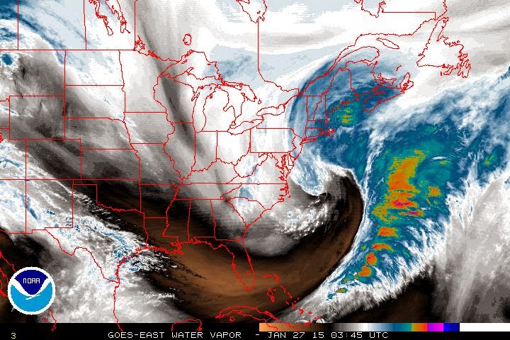
A Nor'easter hit the East Coast with blizzard conditions and 3 feet of snow over the last two days (Jan 26-28). Blizzard warnings (red) were issued along the coast from New Jersey to Maine, and hurricane force wind warnings (brown) for an area around Cape Cod:
The heaviest snow (3 feet) fell only 30-50 miles from the coast in Massachusetts (Auburn, Hudson, Lunenburg). Winds gusted to 75 mph on Cape Cod (Chatham), and 78 mph on Nantucket. NAM analysis charts for Tuesday morning indicate a huge mid level trough, and an 80+ knot low level jet going across a 20C temperature gradient:
32.2 foot waves were recorded at buoy 44037 (well northeast of Boston).
A storm which affected the West Coast from Wednesday, Dec 10 through Friday, Dec 12 hit California with 14.48" of rain (Whiskeytown), 19.8" of snow (Lodgepole), and a 139 mph wind gust (Benton). Numerous other locations reported very heavy rainfall and 100+ mph winds. From the Weather Prediction Center's storm summary:
...SELECTED STORM TOTAL RAINFALL IN INCHES FROM 900 AM PST WED DEC
10 THROUGH 600 PM PST FRI DEC 12...

...CALIFORNIA...
WHISKEYTOWN 1 SSW                    14.48
LAKESHORE SHASTA CO                  11.24
HAWKEYE                              11.22
BOGGS MOUNTAIN RAWS                  10.24
PESCADERO                             9.70
GIRARD                                9.64
MT. SAINT HELENA                      9.06
BOULDER CREEK 9 WNW                   8.89
SHASTA DAM                            8.88
WHISPERING PINES                      8.76
MINERAL                               8.47
BIG SUR RAWS                          8.31
STIRLING CITY                         8.27
YORKVILLE                             7.52
SAN MARCOS PASS                       5.23
LOS PRIETOS                           4.31
SAN FRANCISCO 2 SSW                   4.28
LYTLE CREEK RAWS                      3.93
ORO GRANDE                            3.73
MONTERY NWS                           3.54
LAKE ARROWHEAD NW                     3.49
SAN FRANCISCO DOWNTOWN                3.46
PASADENA                              3.43
SAN JOSE ARPT                         3.39
SACRAMENTO 2 SE                       3.33
OAKLAND ARPT                          3.22
SANTIAGO PEAK                         3.00
BEVERLY HILLS                         1.91
LA DOWNTOWN                           1.58
SANTA ANA                             1.58

...OREGON...
GOLD BEACH                            2.78
SELMA 5 NNE                           2.53
OBRIEN 2 SSW                          2.14
MERLIN 2 W                            2.11
LEES CAMP                             1.90
FLORENCE 2 NW                         1.45
HASKINS DAM                           1.20
DALLAS                                1.11

...SELECTED STORM TOTAL SNOWFALL IN INCHES FROM 900 AM PST WED DEC
10 THROUGH 600 PM PST FRI DEC 12...

...CALIFORNIA...
LODGEPOLE 9 N                        19.8
DONNER SUMMIT                        19.0
SODA SPRINGS 3 ENE                   19.0
CARSON PASS                          16.0
SQUAW VALLEY                         16.0
BLUE CANYON                          14.8
ALPINE MEADOWS                       14.0
DEVILS POSTPILE 7 NNW                14.0
KINGVALE                             13.0
KIRKWOOD MEADOWS 1 SE                13.0
LAKE WISHON 4 ENE                    10.5
MANZANIA LAKE 1 WNW                  10.0
KINGVALE 1 W                          9.0
BIG BEAR RESORT                       8.0
FAWNSKIN                              6.5
BASS LAKE 11 E                        5.8
TWAIN 6 S                             4.0
FLORENCE LAKE 7 WNW                   3.0
OAKHURST 8 N                          2.5
YOSEMITE VALLEY 1 NNE                 0.7

...SELECTED PEAK WIND GUSTS IN MILES PER HOUR EARLIER IN THE
EVENT...

...CALIFORNIA...
SODA SPRINGS 4 SE                    135
WHITE MOUNTAIN PEAK NE               113
INCLINE VILLAGE 6 NE                 112
MAMMOTH LAKES 3 W                    111
ALPINE MEADOWS 1 SW                  109
GRAPEVINE 3 SSE                      105
SIERRAVILLE 5 SSE                     74
KEENE 7 SW                            71
MT. DIABLO                            68
WOODACRE                              63
GASQUET 12 SE                         62
WEITCHPEC 11 WSW                      60
PETROLIA 4 S                          58
CRESCENT CITY 1 ESE                   53
KNEELAND                              50

...NEVADA...
BENTON 4 E                           139
BLUE EAGLE RANCH 11 SSE               96
GARDNERVILLE 5 WSW                    93
GALENA E                              82
GREAT BASIN NATION 3 WNW              78
CARSON CITY 3 ENE                     76
RENO 4 SE                             70
SPANISH SPRINGS AIR 3 W               66
VERDI 4 E                             63
EUREKA AIRPORT                        60

...OREGON...
RUCH 12 S                            117
SQUAW PEAK                           117
CAYUSE 1 WNW                          95
MILTON-FREEWATER 11 ENE               91
MT HEBO                               90
MT. HEBO                              90
PORT ORFORD 5 SE                      90
TILLAMOOK 15 ESE                      90
SEA LION CAVES                        89
MARYS PEAK                            88
BROOKINGS 1 SE                        81
NEWPORT SOUTH JETTY                   79
KOOSKOOSKIE 3 WSW                     78
SPRAGUE RIVER 12 NNW                  76
PENDLETON 10 SE                       75
SUTHERLIN 7 ESE                       75
YACHAT NNW                            75
ASHLAND 1 ENE                         74
PORTLAND ARPT                         67

...WASHINGTON...
NASELLE                               77
PORT TOWNSEND 3 E                     70
DIXIE                                 64
WALLA WALLA                           63
CAMANO 2 SSE                          61
WAITSBURG                             61
FREELAND 2 SSE                        59
PORT TOWNSEND 1 SE                    59
MCCHORD AFB                           58
BANKS                                 56
VANCOUVER LAKE 2 NNE                  55
At Buoy 46015 - 15 nautical miles west of Port Orford, OR (near Medford) - wave heights reached 31.5 feet:
Waves were as high as 15.7 feet as far south as buoy 46047 - 121 nautical miles west of San Diego.
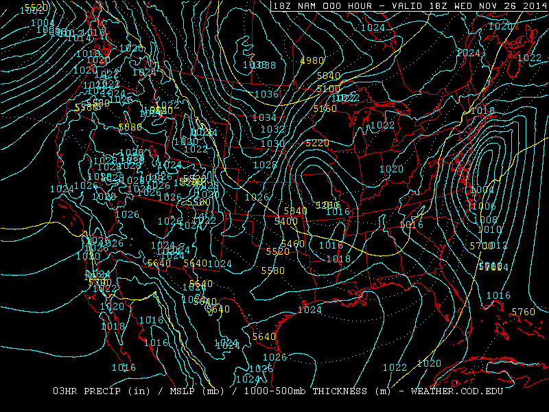
Yesterday (Nov 26, day before Thanksgiving), a Nor'Easter hit Massachusetts with 15" of snow (Savoy) and West Virginia with 20" (Paw Paw). One interesting feature of this storm was that because of an isothermal layer from 700-550 mb seen in the Albany, NY sounding, heavy snow fell over 100 miles south of the 540 line.
With temperatures at or above -10C up to the 550 mb level, heavy wet snow fell and caused over 350,000 power outages.
This storm pushed polar air deep into the Gulf of Mexico. At station 42002, 207 nautical miles east of Brownsville, TX the dew point dropped into the mid 30s:
From November 12th to the 18th, there were 180 consecutive hours below freezing - a new record for November. The old record was 172 hours November 24th to 30th in 1903. There were eight consecutive days with at least a trace of snow From November 12th to 18th. This is the earliest this has been recorded for Chicago. The old record was from November 13 to 20th 1937.
Snow began falling in Upstate New York on Monday, Nov 17, and ended tonight. The highest total was 88" from Cowlesville (about 15 miles east of Buffalo). Second highest was 79.5" in Hamburg (8 miles south of Buffalo). See pictures here. It has been reported that 30 roofs have collapsed under the weight of the snow.
Yesterday, accumulating snow fell from the Great Lakes to the Southern Appalachians:
A 69 mph wind gust was measured at Gary Airport in Indiana. The South Lake Michigan Buoy recorded a 51 knot (59mph) gust, which is the second highest since 1981. It also reported a tie for the second highest wave height - 21.7 feet.
This morning (Nov 1), freezing temperatures occurred across Oklahoma, Arkansas, and Northern Mississippi. Tonight, the freeze may reach the Florida Panhandle:
A potent storm system is expected move from Manitoba to the Southeast US over the next three days. By Friday evening, 850 temps as cold as -10C are forecast reach the south Lake Michigan buoy, where the water temperature is currently 53F:
This would result in a lake-850 delta t of over 20C, which could produce thunder snow for Halloween in Wisconsin, Michigan, Northwest Indiana and Chicago. In addition, with temperatures dropping into the upper 30s combined with 30 mph winds with gusts near 50, wind chill values may be as low as 20, along with blowing snow. Winds will be even stronger over the Lakes, resulting in waves over 20 feet. A storm warning has just been issued for southern Lake Michigan, and a lakeshore flood advisory has been issued for Chicago, Northwest Indiana and Southwest Michigan.
Significant snow accumulations are likely in the Central and Southern Appalachians on Halloween. Freezing temperatures may reach Oklahoma and Tennessee by Saturday morning.
Snow will begin falling in the Northern Rockies tomorrow, and by Thursday night into Friday morning, the snow may reach northeast Colorado and western Nebraska - minor accumulation is possible. This would be on September 11 and 12. I don't remember ever seeing accumulating snow in Nebraska this early.
The same storm which produced tornadoes in eastern Nebraska, also produced heavy snow in western Nebraska:
5" of snow fell at Scottsbluff (2.7 WNW), 1" fell in northwest Kansas (Kanorado), and 43" fell in Wyoming (Encampment 19 WSW).
Here is a radar review from the Hastings and Omaha Radar sites. York received 7.07" of rain from these storms and from some earlier that day.
We followed the main supercell from south of York to slightly East of Omaha. Here is some of what we saw
A huge inflow band seen from Rd 4, 1 mile west of McCool, or 9 miles south of York, NE at 4:30 PM CDT:
There was flying debris with an intense RFD near Cordova. This was on Route 76A between Cordova, NE and Highway US 6 from 5:05-5:08 PM CDT. A funnel may be visible at 1:33.
It became a large high-precipitation supercell by the time it passed near Linlocln. This was shot from near Omaha along I-680 at 72nd street from 7:25-7:29 PM CDT:
Now we are on I-680 just west of where it joins I-80 in Iowa or 3 miles north of Neola, IA at 8:02 PM CDT:
It has now been over a month since the vernal equinox, and the Great Lakes are still 39.9% ice covered:
Most of the Great Lakes area was over 8 degrees F below normal in March and slightly below normal so far in April:
In Michigan, Detroit and Flint have now had the snowiest season on record. On April 15th, Detroit had 3.2" of snow, putting the total for the 2013-2014 season at 94.9". The previous record of 93.6" goes all the way back to the 1880-1881 season.
This morning, a storm hit Cape Cod with heavy snow and hurricane force winds, causing 7,800 power outages. Nantucket was hit with 9.5" of snow and 83 mph winds. The surface low was at 955 mb today, about 250 miles east of Cape Cod.
I am a self taught meteorologist and storm chaser. Much of my original interest came from Joe D'Aleo. I was later interested in the work of Theodor Landscheidt. My views on politics and economics are very close to those of Walter E Williams.