On Christmas Eve, a storm with a central pressure of 929 millibars hit the UK:
For comparison, Hurricane Sandy had a minimum central pressure of 940 mb. An eye was visible in satellite imagery (top center of image):
Just two days later the UK was hit by a storm of 943 mb:
Yesterday, a 948 mb storm was near the Kamchatka Peninsula:
Some have said that the storms affecting the UK are related to "climate change". "Climate change" really just means enhanced greenhouse effect. Increasing greenhouse concentrations would produce the most warming where the greenhouse effect is weakest because that is where infrared transparency is greatest and where there is the most infrared escaping into space that could potentially be absorbed. This tends to be cold polar regions because cold air can contain only very limited amounts of water vapor, the dominant greenhouse gas. Since enhancing the greenhouse effect warms cold areas faster, the temperature contrast is reduced. Extratropical storms such as the one that recently hit the UK are caused primarily by a strong temperature contrast. So "climate change" should reduce the intensity of extratropical storms. Hurricanes on the other hand, are powered primarily by the release of latent heat, not by temperature contrasts.
Dec 29, 2013
Dec 24, 2013
Late December Winter Storm
From December 21-23, this storm produced 15.5" of snow at Larned, KS, 25.2 " of snow at Ashland, WI, 1.25" of freezing rain in New York (Canton, Potsdam, Rensselaer Falls), and 10.24" of rain at Williams, IN:
Tornadoes and widespread wind damage occurred on December 21st:
3 fatalities were reported. One from an EF-2 in Arkansas, another from an EF-2 in Mississippi, and one from wind in Mississippi. All three were in mobile homes.
Last night, temperatures as cold as -20 occurred as far south as Dubuque, Iowa.
Dec 10, 2013
Chicago Area Cold
Temperatures went below zero across most of the Chicago area this morning:
The -6 at O'Hare Airport was the coldest this early in December since 1978. The -6 was surprising because NAM MOS had been predicting 4 yesterday.
In Australia, significant snow fell on December 5th in New South Wales.
OFFICIAL AND SUPPLEMENTARY NWS OBSERVATION SITES
------------------------------------------------
AURORA/SUGAR GROVE:  -13
ROCHELLE:            -13
DUPAGE AIRPORT:      -10
ROCKFORD AIRPORT:     -9
WAUKEGAN AIRPORT:     -7
CHICAGO-O`HARE:       -6
JOLIET:               -5
KANKAKEE:             -5
LANSING:              -5
NWS ROMEOVILLE:       -4
WHEELING/CHI EXEC:    -4
VALPARAISO IN:        -3
PONTIAC:              -2
PERU:                 -1
CHICAGO-MIDWAY:        1
RENSSELAER:            1
CHICAGO-NORTHERLY ISL: 3
The -6 at O'Hare Airport was the coldest this early in December since 1978. The -6 was surprising because NAM MOS had been predicting 4 yesterday.
In Australia, significant snow fell on December 5th in New South Wales.
Dec 9, 2013
Early December Snow Cover
Today, snow already covers 66.9% of the Contiguous US:
With snowpack temperatures well below freezing even in Texas, the snow may be slow to melt:
With snowpack temperatures well below freezing even in Texas, the snow may be slow to melt:
Dec 7, 2013
Southern Winter Storm
A winter storm has impacted the Southern Plains and Ohio Valley just 10 days after the first winter storm of the season hit the same area. By December 5th, there were winter storm warnings from Texas to Ohio, ice storm warnings from Texas to Tennessee, freeze warnings for southern Arizona, and wind chill advisories across the Northern Plains:
One foot of snow fell as far south as Arkansas:
This storm also produced 1.25" of ice in Arkansas and Oklahoma, and 3.5" of sleet at Little Elm, TX.
Yesterday morning's (Dec 6) lows in Arizona were: Tucson 33, Safford 26, Douglas 23, Flagstaff 3, Grand Canyon -2. Extreme cold continues across the Northern Plains and Northern Rockies this morning with Jordan, MT reporting a temperature as low as -42, with a wind chill of -61.
Nov 28, 2013
November Winter Storm
This storm prompted winter storm warnings and produced accumulating snow in central Texas as early as November 24th:
By November 26th, heavy snow fell through the Ohio Valley, while a tornado watch was issued for the Carolinas, and a freeze warning for New Orleans:
An EF-2 tornado hit Atlantic Beach, NC. On the morning of the 28th, a low temperature of 32 was observed at the New Orleans Naval Air Station. This storm also produced 41" of snow at Abajao, UT, 5.20" of rain at Mount Lemmon, AZ, 11.4" of snow at Flagstaff, AZ, and 2" of freezing rain at Odessa, TX.
Nov 21, 2013
November 17 Tornado Damage Tracks
Some tornado tracks from the November 17th outbreak:
The EF-4 Washington tornado killed 1 and injured 125. The NWS in St. Louis has indicated that EF-4 damage occurred a few miles southwest of New Minden where there were an additional 2 fatalities.
Nov 18, 2013
Illinois Tornadoes November 17 2013
I managed to get some spectacular video of the EF-4 tornado that hit Washington, IL:
This video begins at 11:23 AM CST from 1 mile west of Benson, IL in Woodford County, at the junction of route 116 and 117. We are about 20 east-northeast of Peoria.
Damage along I-39:
Radar imagery shows a classic hook and a 70+ knot rotational couplet (delta v probably around 150 knots):
This video begins at 11:23 AM CST from 1 mile west of Benson, IL in Woodford County, at the junction of route 116 and 117. We are about 20 east-northeast of Peoria.
Damage along I-39:
Radar imagery shows a classic hook and a 70+ knot rotational couplet (delta v probably around 150 knots):
This tornado formed in an area with 1,000-1,500 CAPE, 400-500 helicity, 62-64 dew points, 50+ knot low level jet, and an impressive 500 mb left exit region. The tornado developed at 1705Z and passed about 1/3 of the way from Lincoln (sounding at 16Z) to Davenport (sounding at 14Z):
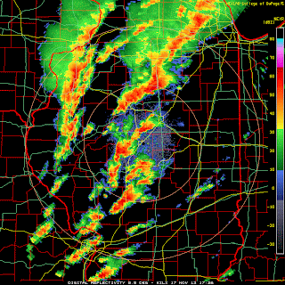
Storm reports from the 17th:
The NHC has named a storm in the Central Atlantic Melissa, but it does not appear to be tropical in nature. It is on the lower right.
Nov 13, 2013
October Tornadoes and Blizzard
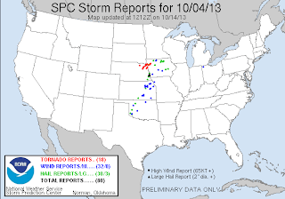
On October 3rd and 4th, blizzard warnings (red) were active in South Dakota, while tornado watches (yellow) were issued in eastern Nebraska:
Damaging tornadoes occurred on both days.
EF-4 tornadoes hit Wayne, NE and Pierson, IA (links have pictures). Meanwhile in South Dakota, 58 inches of snow fell at Beulah, and a 71 mph wind gust was reported at Ellsworth AFB in Meade. At Rapid City, SD, 23.1" of snow from this one storm broke the old record of 15.1" for the entire month of October. Visible satellite from October 5th:
From October 24th - 26th, freeze warnings and frost advisories were issued across most of the Southeast US:
On the morning of the 26th, Macon, GA had a low of 30.
On the morning of November 12th, this cold air mass produced a low of -1 at Aberdeen, SD and -1 Spencer, IA. Freeze warnings have been issued along the Gulf Coast.
Sep 27, 2013
September Mountain Snow
Significant snow accumulations have already occurred on September 25th across the Northern Rockies and the Cascade Range:
On September 26th, heavy snow fell in the Sierra Nevada Range:
The cold air responsible:
On September 26th, heavy snow fell in the Sierra Nevada Range:
The cold air responsible:
Subscribe to:
Comments (Atom)


.png)


