Dec 13, 2014

West Coast Storm


A storm which affected the West Coast from Wednesday, Dec 10 through Friday, Dec 12 hit California with 14.48" of rain (Whiskeytown), 19.8" of snow (Lodgepole), and a 139 mph wind gust (Benton). Numerous other locations reported very heavy rainfall and 100+ mph winds. From the Weather Prediction Center's storm summary:

...SELECTED STORM TOTAL RAINFALL IN INCHES FROM 900 AM PST WED DEC
10 THROUGH 600 PM PST FRI DEC 12...

...CALIFORNIA...
WHISKEYTOWN 1 SSW                    14.48                    
LAKESHORE SHASTA CO                  11.24                    
HAWKEYE                              11.22                    
BOGGS MOUNTAIN RAWS                  10.24                    
PESCADERO                             9.70                    
GIRARD                                9.64                    
MT. SAINT HELENA                      9.06                    
BOULDER CREEK 9 WNW                   8.89                    
SHASTA DAM                            8.88                    
WHISPERING PINES                      8.76                    
MINERAL                               8.47                    
BIG SUR RAWS                          8.31                    
STIRLING CITY                         8.27                    
YORKVILLE                             7.52                    
SAN MARCOS PASS                       5.23                    
LOS PRIETOS                           4.31                    
SAN FRANCISCO 2 SSW                   4.28                    
LYTLE CREEK RAWS                      3.93                    
ORO GRANDE                            3.73                    
MONTERY NWS                           3.54                    
LAKE ARROWHEAD NW                     3.49                    
SAN FRANCISCO DOWNTOWN                3.46                    
PASADENA                              3.43                    
SAN JOSE ARPT                         3.39                    
SACRAMENTO 2 SE                       3.33                    
OAKLAND ARPT                          3.22                    
SANTIAGO PEAK                         3.00                    
BEVERLY HILLS                         1.91                    
LA DOWNTOWN                           1.58                    
SANTA ANA                             1.58                    

...OREGON...
GOLD BEACH                            2.78                    
SELMA 5 NNE                           2.53                    
OBRIEN 2 SSW                          2.14                    
MERLIN 2 W                            2.11                    
LEES CAMP                             1.90                    
FLORENCE 2 NW                         1.45                    
HASKINS DAM                           1.20                    
DALLAS                                1.11                    

...SELECTED STORM TOTAL SNOWFALL IN INCHES FROM 900 AM PST WED DEC
10 THROUGH 600 PM PST FRI DEC 12...

...CALIFORNIA...
LODGEPOLE 9 N                        19.8                    
DONNER SUMMIT                        19.0                    
SODA SPRINGS 3 ENE                   19.0                    
CARSON PASS                          16.0                    
SQUAW VALLEY                         16.0                    
BLUE CANYON                          14.8                    
ALPINE MEADOWS                       14.0                    
DEVILS POSTPILE 7 NNW                14.0                    
KINGVALE                             13.0                    
KIRKWOOD MEADOWS 1 SE                13.0                    
LAKE WISHON 4 ENE                    10.5                    
MANZANIA LAKE 1 WNW                  10.0                    
KINGVALE 1 W                          9.0                    
BIG BEAR RESORT                       8.0                    
FAWNSKIN                              6.5                    
BASS LAKE 11 E                        5.8                    
TWAIN 6 S                             4.0                    
FLORENCE LAKE 7 WNW                   3.0                    
OAKHURST 8 N                          2.5                    
YOSEMITE VALLEY 1 NNE                 0.7                    

...SELECTED PEAK WIND GUSTS IN MILES PER HOUR EARLIER IN THE
EVENT...

...CALIFORNIA...
SODA SPRINGS 4 SE                    135                    
WHITE MOUNTAIN PEAK NE               113                    
INCLINE VILLAGE 6 NE                 112                    
MAMMOTH LAKES 3 W                    111                    
ALPINE MEADOWS 1 SW                  109                    
GRAPEVINE 3 SSE                      105                    
SIERRAVILLE 5 SSE                     74                    
KEENE 7 SW                            71                    
MT. DIABLO                            68                    
WOODACRE                              63                    
GASQUET 12 SE                         62                    
WEITCHPEC 11 WSW                      60                    
PETROLIA 4 S                          58                    
CRESCENT CITY 1 ESE                   53                    
KNEELAND                              50                    

...NEVADA...
BENTON 4 E                           139                    
BLUE EAGLE RANCH 11 SSE               96                    
GARDNERVILLE 5 WSW                    93                    
GALENA E                              82                    
GREAT BASIN NATION 3 WNW              78                    
CARSON CITY 3 ENE                     76                    
RENO 4 SE                             70                    
SPANISH SPRINGS AIR 3 W               66                    
VERDI 4 E                             63                    
EUREKA AIRPORT                        60                    

...OREGON...
RUCH 12 S                            117                    
SQUAW PEAK                           117                    
CAYUSE 1 WNW                          95                    
MILTON-FREEWATER 11 ENE               91                    
MT HEBO                               90                    
MT. HEBO                              90                    
PORT ORFORD 5 SE                      90                    
TILLAMOOK 15 ESE                      90                    
SEA LION CAVES                        89                    
MARYS PEAK                            88                    
BROOKINGS 1 SE                        81                    
NEWPORT SOUTH JETTY                   79                    
KOOSKOOSKIE 3 WSW                     78                    
SPRAGUE RIVER 12 NNW                  76                    
PENDLETON 10 SE                       75                    
SUTHERLIN 7 ESE                       75                    
YACHAT NNW                            75                    
ASHLAND 1 ENE                         74                    
PORTLAND ARPT                         67                    

...WASHINGTON...
NASELLE                               77                    
PORT TOWNSEND 3 E                     70                    
DIXIE                                 64                    
WALLA WALLA                           63                    
CAMANO 2 SSE                          61                    
WAITSBURG                             61                    
FREELAND 2 SSE                        59                    
PORT TOWNSEND 1 SE                    59                    
MCCHORD AFB                           58                    
BANKS                                 56                    
VANCOUVER LAKE 2 NNE                  55                    

At Buoy 46015 - 15 nautical miles west of Port Orford, OR (near Medford) - wave heights reached 31.5 feet:
Waves were as high as 15.7 feet as far south as buoy 46047 - 121 nautical miles west of San Diego.

This storm knocked out power to at least 113,000 customers, produced damaging mudslides including this one at Camarillo Springs, and even produced an EF0 tornado in South Los Angeles.

Dec 9, 2014

941 MB North Atlantic Storm


On December 9th at 6Z, a storm in the north Atlantic reached a minimum pressure of 941 mb. Buoy 64045 is located about 1/3 of the way from Ireland to Iceland. It reported 45.9 foot waves just two hours ago:
ASCAT data indicates that winds were 60 knots just southwest of Iceland:

Nov 27, 2014

Thanksgiving Snowstorm

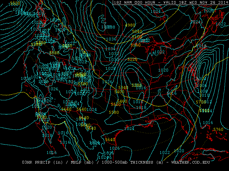
Yesterday (Nov 26, day before Thanksgiving), a Nor'Easter hit Massachusetts with 15" of snow (Savoy) and West Virginia with 20" (Paw Paw). One interesting feature of this storm was that because of an isothermal layer from 700-550 mb seen in the Albany, NY sounding, heavy snow fell over 100 miles south of the 540 line.


With temperatures at or above -10C up to the 550 mb level, heavy wet snow fell and caused over 350,000 power outages.

This storm pushed polar air deep into the Gulf of Mexico. At station 42002, 207 nautical miles east of Brownsville, TX the dew point dropped into the mid 30s:

Nov 26, 2014

Siberian Cold

Temperatures in Siberia have already dropped to -61 F (-52 C). A Russian plane that was stuck because the wheels were frozen to the ground was pushed by the passengers. 850 temps are well below normal in Siberia for this time of year:
For comparison, here is the same chart from the same time last year:

Nov 25, 2014

Record Cold And Snow In Chicago

From November 12th to the 18th, there were 180 consecutive hours below freezing - a new record for November. The old record was 172 hours November 24th to 30th in 1903. There were eight consecutive days with at least a trace of snow From November 12th to 18th. This is the earliest this has been recorded for Chicago. The old record was from November 13 to 20th 1937.
Nov 21, 2014

Buffalo Snow

Snow began falling in Upstate New York on Monday, Nov 17, and ended tonight. The highest total was 88" from Cowlesville (about 15 miles east of Buffalo). Second highest was 79.5" in Hamburg (8 miles south of Buffalo). See pictures here. It has been reported that 30 roofs have collapsed under the weight of the snow.

Nov 19, 2014

Record Cold In Florida

Low temperatures from this morning include:
31 at New Orleans
23 at Mobile
25 at Pensacola (new record, old record 28 in 1903)
22 at Tallahassee (new record, old record 25 in 2008)
27 at Jacksonville (new record, old record 28 in 2008)
41 at Tampa

Nov 18, 2014

Hard Freeze Warning In Florida

A hard freeze warning is in effect for tonight for most of northern Florida, including Ocala. Orlando is under a wind chill advisory (light blue):
Yesterday morning's (Nov 17) lows included 23 at Dallas and 37 at Corpus Christi. This morning it was 24 in Atlanta and 27 at Mobile Regional Airport. This air mass is moving into Florida now:

Nov 17, 2014

Near Record Low Tornado Numbers

For the third consecutive year, the number of tornadoes reported in the US is near or at record lows. The min/max lines are based on data from 1954-2007.


Here are the last 10 years on the same chart. All three of the last years are clustered at the bottom.

Nov 14, 2014

Gulf Coast Freeze

This morning, Nov 14, the low temperature at downtown Mobile and Pensacola was 32. Similar temps are expected again tonight. All models indicate that the next surge of arctic air on Tuesday will be even colder.

Jordan, MT had a low of -26 this morning. Casper, WY was -27 the night of Nov 14.

Nov 9, 2014

Bering Sea Storm Update

Aqua/MODIS image of the Bering Sea at 00:35Z Nov 9

The Bering Sea storm produced 31.2 foot waves at station 46072 on Nov 8 at 3:50 PM AKST. 44.7 knot wind gusts were reported at 6:50 AM on Nov 9 from the same station.

Nov 8, 2014

Bering Sea Storm

Aqua/MODIS image of the western Bering Sea at 1:30Z Nov 8

Super Typhoon Nuri was absorbed into an extratropical storm two days ago. Last night (at 6Z), it reached a minimum pressure of 924 mb as it entered the Bering Sea:
This storm went from 964 mb at 12Z Nov 7, to 927 mb at  0Z Nov 8 - an incredible 37 mb drop in just 12 hours. Although buoy data is sparse, station 46035 in the central Bering Sea reported a 44.7 knot wind gust and 26.6 foot waves. Here is the latest satellite imagery:


Nov 1, 2014

Halloween Storm

Yesterday, accumulating snow fell from the Great Lakes to the Southern Appalachians:
A 69 mph wind gust was measured at Gary Airport in Indiana. The South Lake Michigan Buoy recorded a 51 knot (59mph) gust, which is the second highest since 1981. It also reported a tie for the second highest wave height - 21.7 feet.

This morning (Nov 1), freezing temperatures occurred across Oklahoma, Arkansas, and Northern Mississippi. Tonight, the freeze may reach the Florida Panhandle:

Oct 30, 2014

Winter Conditions For Great Lakes On Halloween

A potent storm system is expected move from Manitoba to the Southeast US over the next three days. By Friday evening, 850 temps as cold as -10C are forecast reach the south Lake Michigan buoy, where the water temperature is currently 53F:
This would result in a lake-850 delta t of over 20C, which could produce thunder snow for Halloween in Wisconsin, Michigan, Northwest Indiana and Chicago. In addition, with temperatures dropping into the upper 30s combined with 30 mph winds with gusts near 50, wind chill values may be as low as 20, along with blowing snow. Winds will be even stronger over the Lakes, resulting in waves over 20 feet. A storm warning has just been issued for southern Lake Michigan, and a lakeshore flood advisory has been issued for Chicago, Northwest Indiana and Southwest Michigan.

Significant snow accumulations are likely in the Central and Southern Appalachians on Halloween. Freezing temperatures may reach Oklahoma and Tennessee by Saturday morning.

Sep 16, 2014

Hurricane Edouard

Hurricane Edouard reached category 3 intensity today at 1500Z. Winds are estimated to be 100 knots (115 mph), and pressure 955 mb. Edouard is passing to the east of Bermuda (far left in the image below), and has no chance of landfall.

Edouard is the first Atlantic hurricane to reach category 3 strength since Sandy did on October 25th, 2012.

Sep 12, 2014

Nebraska Snow

Snow began falling in western Nebraska last night. Minor accumulations occurred in the Sandhills area:
I have never seen accumulating snow in Nebraska as early as September 11th.

Sep 9, 2014

Snow Likely In The Central High Plains

Snow will begin falling in the Northern Rockies tomorrow, and by Thursday night into Friday morning, the snow may reach northeast Colorado and western Nebraska - minor accumulation is possible. This would be on September 11 and 12. I don't remember ever seeing accumulating snow in Nebraska this early.

Sep 8, 2014

Storm Chasing Videos

All my storm chasing videos are organized chronologically here. A link has also been added in the sidebar to the right under "Links".

Aug 28, 2014

Storm Chases From 2010

On June 7th, 2010 at 7:22 MDT, a storm over Scottsbluff, NE began to rotate. We were so close, and the area of rotation so large, that it was difficult to fit it into the field of view:

Just two minutes later, a tornado touches down in Scottsbluff. Although the tornado is very difficult to see, several power flashes are visible. The tornado was rated EF-1. This video runs from 7:23-7:24 MDT:
40 minutes later, as we tracked the storm to Bridgeport, NE, it becomes the darkest storm I've ever seen. This is from 8:01-8:05 PM MDT, and sunset was at 8:25:
The next day, instead of storm chasing, we took a trip through Rocky Mountain National Park. A pileus cloud is seen at 6:20:
On June 11, we saw a storm with vertical (anticyclonic) and horizontal rotation 15 miles north of Strasburg, CO. We are on Headlight Road north of 112th Ave. This is from 4:57-4:59 MDT:
On July 22nd, we saw an intense storm with a well defined shelf cloud approaching Gorney Park in Caledonia, WI. This is from 8:01-8:04 PM CDT:

Aug 2, 2014

Super Typhoon Halong


Super Typhoon Halong reached category 5 today with wind estimated at 140 knots (160 mph). Halong is currently south of Japan, and east of the Philippines. Halong will likely begin to impact Japan on Thursday, August 7.

Jul 29, 2014

Cold Waters and High Waves on the Great Lakes

Today station 45004 on Lake Superior is still reporting water temperature of just 38F. The normal for late July is in the mid 50s.

On Lake Michigan, 33 knot north winds produced 11.4 foot waves at the Michigan City, IN buoy yesterday morning. The large waves produced enough upwelling to drop the water temperature to 58.8 F at the southern Lake Michigan buoy. Water temperatures were around 61 before the big waves hit, which is already about 10 degrees below normal.

Jul 21, 2014

Northern Plains Heat

Heat advisories stretch from Wichita Falls, TX to Duluth, MN today:
The temperature reached 108 in Winner, SD today, with dew point of 52. At York, NE the temperature was 97, the dew point 81, and the heat index 119.

Jul 10, 2014

July Cold

Cold air has spread across northern Wisconsin this morning. Rhinelander had a low temperature of 41, Eagle River 38, and Land O' Lakes 37. Temperatures will likely drop into the 40s in Iowa and Illinois by Monday night (July 14).

Jul 4, 2014

Hurricane Arthur Update

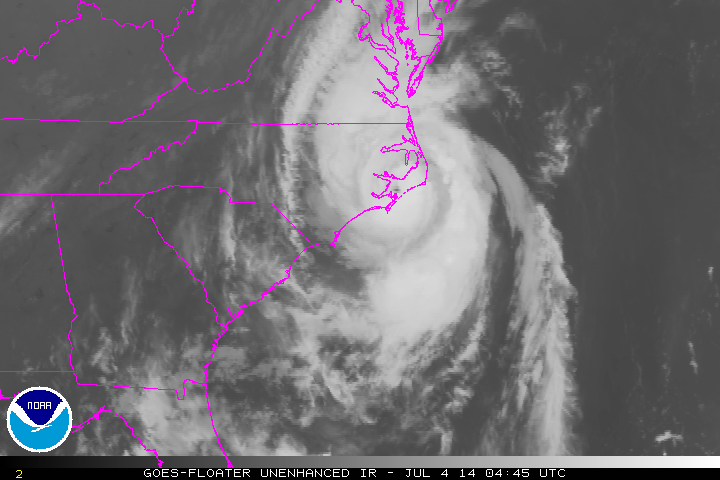
Hurricane Arthur has strengthened to category 2 with wind at 85 knots (100 mph) and a central pressure of 973 mb. Winds have gusted to 73 knots (84 mph) at Cape Lookout, NC and to 79.1 knots (89.9 mph) at Hatteras, NC. Station 41036 (south of Morehead City) has reported 28.9 foot waves. Hurricane Arthur is beginning to accelerate to the northeast and will impact New England and Nova Scotia tomorrow.

Some recent satellite and radar history of Arthur:


Jul 3, 2014

Hurricane Arthur


Hurricane Arthur is now a category one hurricane with winds at 80 knots, and a central pressure of 980 mb. Arthur is moving north toward North Carolina, but a trough approaching the East Coast will cause a turn to the northeast later today. The center of Arthur will most likely pass over Cape Hatteras, but all of the North Carolina coast will be affected with high winds. A station at Wrightsville Beach, NC (near Wilmington) has already reported a 52 knot wind gust. With Arthur passing over water temperatures in the lower 80s, and with weak shear, some strengthening is likely over the next 24 hours.

Jun 17, 2014

Stanton and Pilger NE Storm

Yesterday, we tracked the storm that hit Stanton and Pilger, NE with a strong tornado, from Pender, NE to Sioux City, IA.

There were multiple funnel clouds seen from 1 mile east of Pender on Route 94. This video is from 4:55-5:01 PM CDT on June 16, 2014:
There was good storm stucture a few miles north of Pender, NE on Route 9. This video runs from 5:10-5:12 CDT:
We saw two funnel clouds simultaneously between Pender and Emerson, NE on Route 9. The video runs from 5:13-5:17 PM CDT:
We found ourselves too close to rapid rotation while driving east on Route 35 just northeast of Emerson, NE. The video runs from 5:26-5:28 PM CDT:
There were rapidly rotating funnel clouds just southwest of Hubbard, NE on Route 35. The video runs from 5:32-5:35 PM CDT:
We saw great striations on Route 35 between Hubbard and Dakota City, NE. The video runs from 5:41-5:42 PM CDT:
We saw incredible storm structure on Route 35 between Hubbard and Dakota City, NE. The video is at 5:43 PM CDT:
The supercell had rapid rotation on Route 35 between Hubbard and Dakota City, NE. The video runs from 5:45-5:47 PM CDT:
The tilted updraft was visible from US 75/77 just north of Dakota City, NE as the storm began to weaken. This is from 5:53-5:54 PM CDT:

Jun 12, 2014

Hurricane Christina


Hurricane Christina rapidly intensified from category 1 with winds of 70 knots to category 4 with 130 knot winds over just a 21 hour period. This occurred from June 11th at 21Z to June 12th at 18Z.

Christina is already the second category 4 hurricane in the East Pacific this season. This is the earliest in the season that two hurricanes reached category 4 in the East Pacific since 1966 when satellite monitoring began.