This storm prompted winter storm warnings and produced accumulating snow in central Texas as early as November 24th:
By November 26th, heavy snow fell through the Ohio Valley, while a tornado watch was issued for the Carolinas, and a freeze warning for New Orleans:
An EF-2 tornado hit Atlantic Beach, NC. On the morning of the 28th, a low temperature of 32 was observed at the New Orleans Naval Air Station. This storm also produced 41" of snow at Abajao, UT, 5.20" of rain at Mount Lemmon, AZ, 11.4" of snow at Flagstaff, AZ, and 2" of freezing rain at Odessa, TX.
Nov 28, 2013
Nov 21, 2013
November 17 Tornado Damage Tracks
Some tornado tracks from the November 17th outbreak:
The EF-4 Washington tornado killed 1 and injured 125. The NWS in St. Louis has indicated that EF-4 damage occurred a few miles southwest of New Minden where there were an additional 2 fatalities.
Nov 18, 2013
Illinois Tornadoes November 17 2013
I managed to get some spectacular video of the EF-4 tornado that hit Washington, IL:
This video begins at 11:23 AM CST from 1 mile west of Benson, IL in Woodford County, at the junction of route 116 and 117. We are about 20 east-northeast of Peoria.
Damage along I-39:
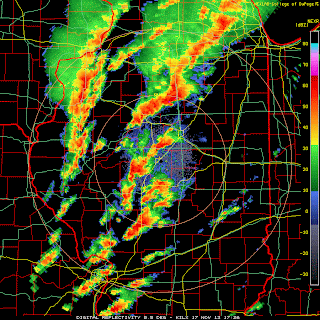
Radar imagery shows a classic hook and a 70+ knot rotational couplet (delta v probably around 150 knots):
This video begins at 11:23 AM CST from 1 mile west of Benson, IL in Woodford County, at the junction of route 116 and 117. We are about 20 east-northeast of Peoria.
Damage along I-39:
Radar imagery shows a classic hook and a 70+ knot rotational couplet (delta v probably around 150 knots):
This tornado formed in an area with 1,000-1,500 CAPE, 400-500 helicity, 62-64 dew points, 50+ knot low level jet, and an impressive 500 mb left exit region. The tornado developed at 1705Z and passed about 1/3 of the way from Lincoln (sounding at 16Z) to Davenport (sounding at 14Z):
Storm reports from the 17th:
The NHC has named a storm in the Central Atlantic Melissa, but it does not appear to be tropical in nature. It is on the lower right.
Nov 13, 2013
October Tornadoes and Blizzard
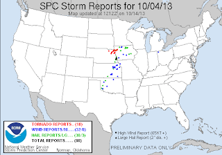
On October 3rd and 4th, blizzard warnings (red) were active in South Dakota, while tornado watches (yellow) were issued in eastern Nebraska:
Damaging tornadoes occurred on both days.
EF-4 tornadoes hit Wayne, NE and Pierson, IA (links have pictures). Meanwhile in South Dakota, 58 inches of snow fell at Beulah, and a 71 mph wind gust was reported at Ellsworth AFB in Meade. At Rapid City, SD, 23.1" of snow from this one storm broke the old record of 15.1" for the entire month of October. Visible satellite from October 5th:
From October 24th - 26th, freeze warnings and frost advisories were issued across most of the Southeast US:
On the morning of the 26th, Macon, GA had a low of 30.
On the morning of November 12th, this cold air mass produced a low of -1 at Aberdeen, SD and -1 Spencer, IA. Freeze warnings have been issued along the Gulf Coast.
Subscribe to:
Comments (Atom)


.png)


