Sep 27, 2013

September Mountain Snow

Significant snow accumulations have already occurred on September 25th across the Northern Rockies and the Cascade Range:
On September 26th, heavy snow fell in the Sierra Nevada Range:
The cold air responsible:

Jul 10, 2013

Lightning Video

A review of some of the most intense lightning video that I have going back to 2000.

0-1:10 Northern Missouri in May 2000.
1:10-1:22 The F-5 Greensburg storm on May 4, 2007.
1:22-1:47 Lightning out the top of the Greensburg storm seen from over 100 miles away.
1:47-3:58 Just south of Corning, KS on June 5, 2008.
3:58-6:45 Texas Panhandle between Borger and Perryton on June 12, 2010.

Jun 26, 2013

Chicago Area MCS

This MCS developed in northern Illinois late last night (June 25th), and produced flooding across the north suburbs of Chicago:

A CoCoRaHS station at Cary reported 6.15" at 7 AM on the 26th.

The COD storm chasers were frustrated yesterday when nothing developed in Iowa. Despite convective inhibition of only 3 on the 0Z Omaha sounding, convective initiation never occurred:

Jun 4, 2013

El Reno Tornado Update

The El Reno, OK tornado of May 31st has been upgraded to EF-5, with a maximum width of 2.6 miles:
The death toll from the El Reno tornado now stands at 18.

Jun 3, 2013

May Tornadoes

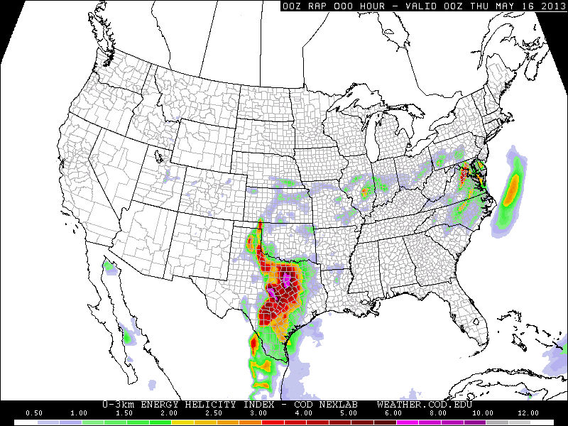
On May 15th, 18 tornadoes touched down across the Dallas-Fort Worth metro including an EF-4 which struck Granbury, killing 6 and injuring dozens. The 500 mb chart for this event was not very impressive with a speed maximum of only 30 knots. However, the southwesterly 30 knot flow at 850 mb combined with surface winds backed to southeasterly produced storm relative helicities (SRH) of 450 0-3 km and 200+ 0-1 km:


On May 19th, 6 tornadoes occurred in central Oklahoma including the EF-4 Shawnee tornado which killed 2. A radar loop is here. Video here and here. A tornado near Clearwater, Kansas was given an EF-2 rating based on radar data from the Doppler on Wheels. The Shawnee tornado was no surprise given a 60 knot southwesterly 500 mb jet, 35-40 knot southerly 850 low-level jet, and locally backed winds near Oklahoma City producing a 0-3 km SRH of 450 and 0-1 km SRH of 300. Note the small bullseye of 10 (top of the scale) in the significant tornado parameter (last chart below) over Oklahoma City.


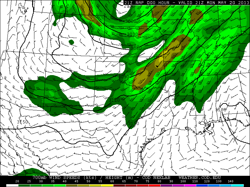
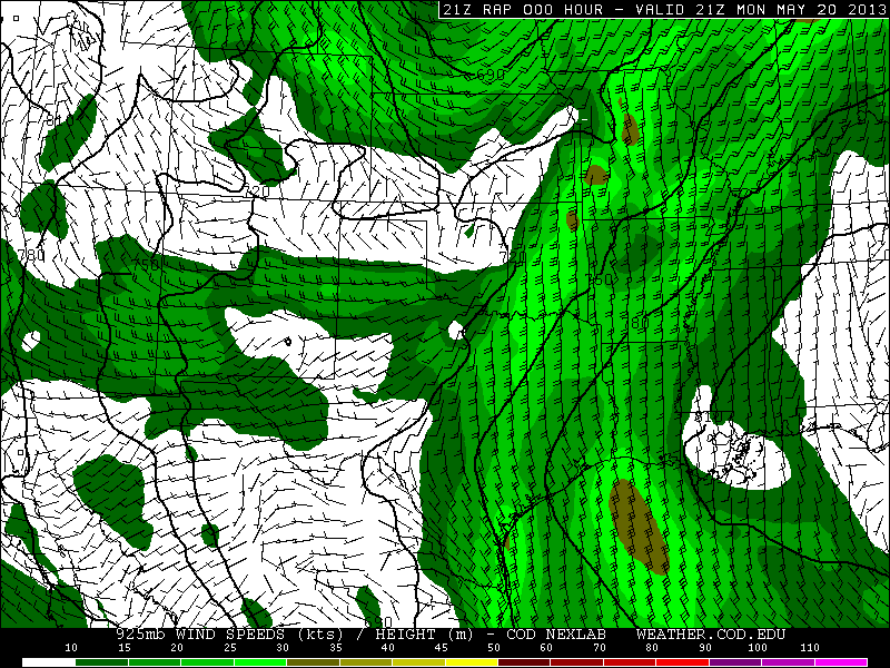
The next day, May 20th, another mid-level speed max ejected into the Southern Plains and produced the 1.3 mile wide EF-5 Moore tornado which killed 24,  injured 377, and damaged or destroyed over 12,000 homes. A radar loop showing debris ball and intense rotational couplet is here and a radar timeline here. See incredible video here, here, here, here, initial touchdown here, and helicopter time lapse here. What surprised me about the Moore tornado is that although the 500 mb speed was 60 knots, and the 700 mb speed was 45 knots, 850 winds were only 25 knots, producing 0-3 km and 0-1 SRH values of just 300 and 150 respectively. Similar to the Shawnee tornado, surface winds were backed only very locally near Oklahoma City, producing a very small bullseye in the significant tornado parameter:


Preliminary damage path for the Moore tornado:
On May 31st, EF-3 tornadoes developed at El Reno, OK and the St. Louis metro. The El Reno tornado killed 13, and hit several storm chase teams, including Tim Samaras, Paul Samaras and Carl Young, all of whom were killed. Video of amazing multiple vortex structure here, and here. See the Weather Channel's Mike Bettes being hit by the tornado here, and here, and other chasers being hit here, and here. Radar loops and photos of the El Reno tornado here. For the El Reno tornado, RAP analysis indicates 500 mb winds west-southwest at 50 knots, 700 mb winds southwest at 40 knots, 850 winds south at 30 knots, and southeast surface winds producing, SRH around 300 0-3km and 150 0-1 km. The Oklahoma City radiosonde observation shows a slightly stronger and much more veered flow immediately above 850 mb, and a 0-3 km SRH of 476:


 I have a number of storm chasing videos on my Youtube channel from last month. This one is probably the most interesting:

Some have speculated that these tornadoes may be linked to global warming. Is is too easy to forget that the 12-month period before the May spike in tornadoes was at a record low:
If deadly tornadoes are evidence of global warming, what does a record quiet period indicate?

May 21, 2013

Snowy April and May 2013

On April 3rd, a narrow band of cold air allowed accumulating snow to fall in central Oklahoma:

On April 9th, a storm ran warm 12C air at 850 mb over cold surface air with temps near freezing:


As a result, a convective squall line moving through central Kansas produced winter conditions at ground level. At 9:00 PM CDT, Concordia was under a severe thunderstorm warning while reporting freezing rain, a temperature of 30, a north wind at 24 mph, gusting to 35, and a wind chill of 16. Salina reported light snow, fog, a temperature of 33, wind northwest at 32, gusting to 38, and a wind chill of 19. Hutchinson reported a thunderstorm with a temperature of 32, fog, wind north at 16 gusting to 36, and a wind chill of 21. Radar from 9:11 CDT:
By 10:00 PM CDT, Hutchinson was reporting hail with a temperature of 32, fog, a north wind at 26 mph gusting to 37, and a wind chill of 18. Radar from 9:54 CDT:
Roads were coated with ice as far south as the Oklahoma-Texas border. Snowfall amounts from this storm include 28.5" at Lander, WY; 24" at Harrison, NE; 30.0" at Deadwood, SD; and a record shattering 28.2" at Rapid City, SD. The previous record from a single storm in Rapid City was 18.0" on April 22, 2001. Some wind gusts from the storm in mph are: 84 at Castaic Lake, CA; 78 at Dubuque, IA; 85 at Menominee, MI.

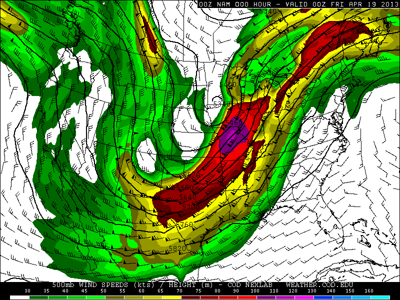
From April 16-19 this storm produced heavy snow from Colorado to Michigan:


Snowfall amounts: 20.0" at Great Basin National Park, NV; 9.5" at Denver, CO; 23.4" at Fort Collins, CO; 33.0" at Virginia Dale, CO; 36.0" at Centennial, WY; 17.3" at Cheyenne, WY; 17.7" at Duluth, MN; 8.1" at Minneapolis, MN; 22.0" at Cornucopia, WI. This storm also produced huge amounts of rain including 8.20" at Pella, IA and 7.34" at Naperville, IL.

Just a few days later, another surge of cold air allowed for snow to fall in Oklahoma and significant accumulations to occur across I-70 in Kansas:


For the morning of April 24th, a freeze warning was issued for Lubbock, TX, and a hard freeze warning for Amarillo, TX:
On April 25th, frost advisories were issued from extreme northern Texas to Tennessee:
On April 24th, low temperatures were 25 at Lubbock, and 20 at Amarillo. On the 25th, Nashville had a low of 36.

On April 26th, Fargo, ND had the latest 50 degree day on record, with the previous record being April 17th in 1881. April was the snowiest month of the 2012-2013 winter season in Fargo.

As of April 26th, the United States had the second coldest start to a spring on record.

On May 1st and 2nd, 850 temps as cold as -4C were reaching Texas:


By May 3rd, a freeze warning was issued for San Angelo, TX, and a winter weather advisory was active for northwest Arkansas:
Accumulating snow fell as far south as northeast Oklahoma and northwest Arkansas:


Up to 5" of snow fell in Arkansas. This is the first time snow has been recorded in Arkansas in the month of May. At Tulsa, OK, snow fell on May 2nd, breaking the previous latest snow on record of April 18th in 1953. Records in Tulsa go back to 1900.

Another surge of cold air prompted a frost advisory for Nashville on May 13th:

Record lows of 39 at Nashville and 33 at Crossville occurred on May 13th.

On May 14th, a blizzard hit the UK with 65 mph wind and power outages.