The 992 mb Lake Michigan storm from September 29th mentioned in my
last post kicked up enough sediment on Lake Michigan to be visible in an Aqua satellite image:

I noticed that it was still present on October 9th in geostationary imagery, as well as on Lake Erie:

This is category 3 Hurricane Ophelia on September 30th north of the Lesser Antilles:


There appears to be some low level outflow on its west side.
Ophelia passing to the east of Bermuda on October 1st:


Three hours after this last image (0Z Oct 2nd), Ophelia was upgraded to a category 4. Peak strength was estimated to be 940 mb/120 knot winds at 3Z Oct 2nd.
Ophelia weakening and moving north toward Newfoundland on October 2nd:


On October 5th, this large western trough produced heavy snow for the entire Sierra Nevada Range.


On the morning of October 6th, this system produced
11 tornadoes in the Flagstaff area, including 2 EF-3s, with temperatures only in the 40s. Flagstaff was under a freeze warning for the morning after the tornadoes struck:

Flagstaff had a low of 27 on October 8th. Note also the frost advisories for the suburbs of Boston, and the tornado warning in Kansas, which was for this cell:


The energy which produced the Flagstaff area tornadoes in the morning had already ejected into the Plains to generate a 988 mb low in the Nebraska Panhandle:


This was in an area with only upper 50s dew points:

But with surface winds up to 30 knots and backed to near southeasterly, helicity values were strong across the Central High Plains:


Another impressive cell developed near Grand Island, NE on October 7th:


A touchdown was reported with this cell in Scott County at 510Z:


On October 6th and 7th, snow fell in northern Arizona and northern New Mexico:

6 inches of snow fell on Cheyenne, WY on October 8th.
And heavy rain fell in Texas:

Areas of Texas which are still in an exceptional drought were under flash flood watches:

Freeze warnings were in effect down to southern New Mexico.
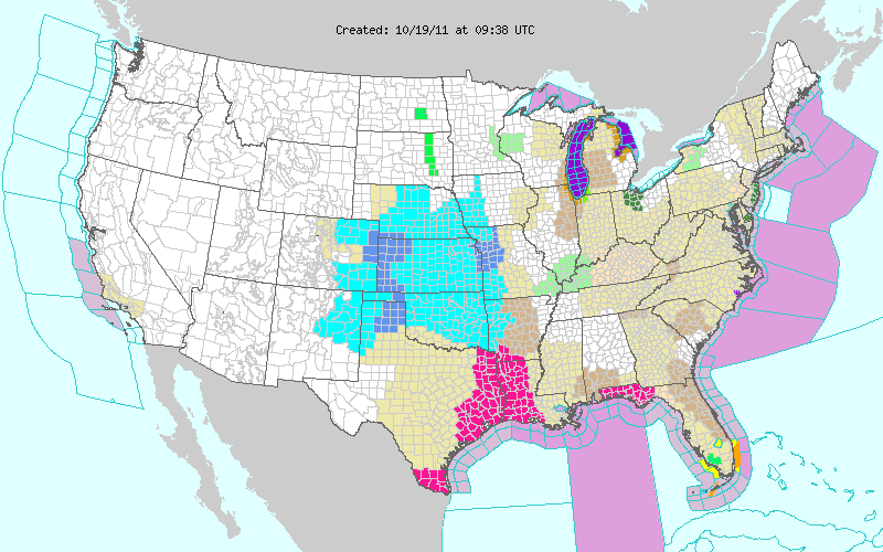
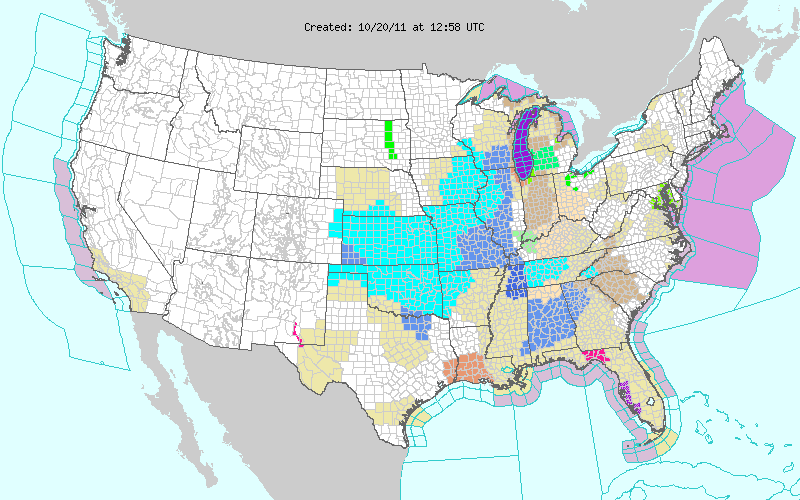
On October 20th, this 983 mb storm prompted storm warnings for Lakes Huron and Michigan, and a high wind warning for the Chicago area:

The Harrison-Dever Crib, near Chicago, recorded a 64 mph gust. A large areas were under frost advisories (blue) and freeze warnings (light blue) following this storm, including the county north of Dallas, and the Florida Panhandle:


The low temperature at Mobile, AL on October 20th was 34. It was 36 at Tallahassee on October 22nd.
Cheyenne, WY received 9.3" of snow, and Denver 8.5" on October 25-26. Then on October 27th, 3.1" fell at Amarillo, TX, with 5" reported 6 miles to the southwest. Laramie, WY had a low temperature of -16 on October 27th, breaking the old record of 7 set in 1970.
NAM indicates that a major nor'easter could drop over a foot of wet snow tomorrow. An area along a line from Washington DC to Boston will be near the rain-snow line. It might even snow on Wall Street...
 On November 3rd, freeze warnings were issued in central Texas (light blue):
 This 986 mb low produced a 68 mph wind gust at Lamar Colorado on November 5th:
 This storm was impressive in water vapor imagery, but also look at that little cut-off low off the East Coast (about 500 miles east of Florida).
 That cut-off low was named Tropical storm Sean just three days later. Here is a surface analysis from November 7th at 18Z, just 15 hours before it was named:
 There is a cold front extending from the low which is to become Sean, to Puerto Rico. There is also a 946 mb low near Greenland. Water vapor and visible imagery from the same time show how much dry air is surrounding it:
 There is also a tornado outbreak beginning in the plains at this time (more on that later). Here is how it looked as it was named Subtropical Storm Sean on November 8th at 9Z (3 AM CST):
 RUC analysis charts indicate that although it had a warm core, there is still considerable temperature contrast across the circulation, especially at 700 mb:
 By 18Z, it had been named Tropical Storm Sean. Here it is 2 hours after:
 Sean passing Bermuda on November 11th:
 Meanwhile, there was a small tornado outbreak on November 7th in southwestern Oklahoma. Notice the mid 60s dewpoints and winds backed to southeasterly particularly around Frederick:
 This coincided with an area of 3,000+ CAPE:
 The result can be seen on the Frederick radar at 2151Z (3:51 PM CST):

 The mesocyclone is easier to see on the 1.3° elevation scan. Same supercell 13 minutes later:
 RUC analysis charts show backed surface winds, a veered 35+ knot low level jet, and strong divergence at 250 mb over southwest Oklahoma:


 The sounding from Oklahoma City has 0-3km SRH at 364, and 1km still at 320:
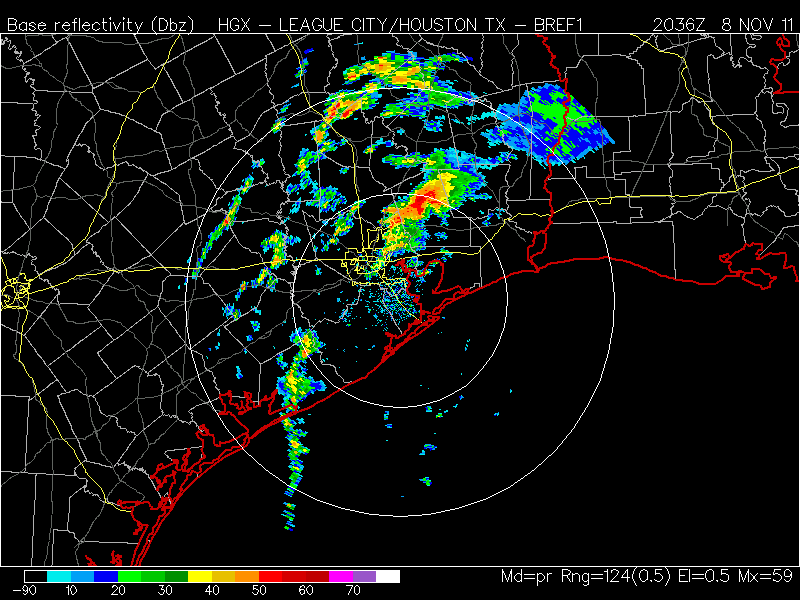
 There were additional tornadic supercells the next day including this one near Houston:
 On November 8th, a 943 mb storm in the Bering Sea hit nearby buoy 46035 with nearly 40 foot waves and 72 knot winds:

 By November 9th, accumulating snow had fallen in Wisconsin and Iowa:
 On November 11th, freeze warnings were in effect for most of the Florida Panhandle:
 On November 25th, a storm reached 940 mb north of the British Isles:
 On November 27th, freeze warnings (light blue) were issued for most of the Texas Gulf Coast:
 On November 28th, accumulating snow fell as far south as northern Mississippi, including Memphis: