Sandy made landfall yesterday around 8 PM EDT (0Z today) near Atlantic City New Jersey. Sandy was at peak strength just three hours earlier with a pressure of 940 mb:
940 mb would normally indicate a category 3 or 4 hurricane, but because Sandy was transitioning to an extra-tropical storm, the wind field was weaker but also much larger than with a normal hurricane.
Water vapor imagery shows dry air entrainment already occurring at least two days before landfall:
Radar imagery from 14 hours before, during, and 15 hours after landfall:
RUC analysis indicated that at the time of landfall, Sandy had a thermal
structure consistent with a hybrid storm - a warm core becoming
surrounded by cold air:
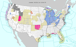
Two days before landfall (October 27th), tropical storm warnings (dark red) and hurricane warnings (lighter red) were active for waters off of almost the entire East Coast. Flood advisories (green) were issued for the Northeast, and Dallas was under a frost advisory:
One day before landfall, hurricane force wind warnings (brown) were issued from Cape Cod to northern Delmarva including part of Chesapeake Bay with storm warnings (purple) further south and hurricane force wind watches (slightly lighter purple) further north. High wind warnings were issued for most of the Northeast. Blizzard warnings (red) and winter storm warnings (pink) were issued for part of the Appalachians. A storm warning was issued as far west as Lake Michigan, and Chicago was (and still is) under a lakeshore flood warning.
So far Sandy has produced up to 12.55" of rain at a CoCoRaHS station at Easton, Md, 9.57" of rain at Oceana Naval Air Station, VA, and 26" of snow at both Redhouse and Garret in Maryland. The heaviest precipitation has been to the south of landfall, but the highest winds have been north of landfall. List of wind reports from HPC:
ISLIP NY                               90 MPH
2 N TOMPKINSVILLE NJ                   90 MPH
SURF CITY NJ                           89 MPH
TUCKERTON NJ                           88 MPH
1 N MONTCLAIR NJ                       88 MPH
MADISON CT                             85 MPH
PLUM ISLAND NY                         84 MPH
CUTTYHUNK MA                           83 MPH
DENNISVILLE                            81 MPH
SANDY HOOK NJ                          81 MPH
WELLFLEET MA                           81 MPH
JFK NY                                 79 MPH
NEWARK NJ                              78 MPH
ATLANTIC CITY NJ                       77 MPH
GROTON CT                              76 MPH
HARVEY CEDARS NJ                       75 MPH
A station at Eatons Neck, NY reported a 96 mph gust at an elevation of 71 feet.
Buoy 44065, 15 nautical miles southeast of Breezy Point, NY (outside of New York Harbor), reported 32.5 foot waves at the time of landfall.
Buoy 4408, 54 nautical miles southeast of Nantucket, reported 36.1 foot waves few hours earlier.
It has been reported that the
storm surge at Manhattan was almost 14 feet, beating the previous record of 10 feet set in 1960 by Hurricane Donna. Storm surge data from NWS NYC:
...MAXIMUM WATER LEVELS FROM POST-TROPICAL CYCLONE SANDY AND
ACCOMPANYING SURGE...

UNITED STATES GEOLOGICAL SURVEY GAUGES

....................MAXIMUM......ASTRONOMICAL..STORM
LOCATION..........WATER LEVEL.....TIDE LEVEL...SURGE.....TIME
FREEPORT..........10.12 FT NGVD..2.27 FT NGVD..7.85 FT...930 PM
REYNOLDS CHANNEL..10.10 FT NGVD..2.32 FT NGVD..7.78 FT...906 PM
LINDENHURST........7.73 FT NGVD..1.47 FT NGVD..6.26 FT..1006 PM
EAST ROCKAWAY.....10.80 FT NGVD..2.72 FT NGVD..8.08 FT...842 PM
JAMAICA...........11.65 FT NGVD..3.28 FT NGVD..8.37 FT...936 PM
ROCKAWAY..........11.75 FT NGVD..2.81 FT NGVD..8.94 FT...924 PM

NATIONAL OCEAN SERVICE GAUGES

....................MAXIMUM......ASTRONOMICAL..STORM
LOCATION..........WATER LEVEL.....TIDE LEVEL...SURGE.....TIME
BERGEN POINT......14.60 FT MLLW..5.15 FT MLLW..9.45 FT...924 PM
BATTERY...........13.88 FT MLLW..4.65 FT MLLW..9.23 FT...924 PM
KINGS POINT.......14.38 FT MLLW..5.60 FT MLLW..8.78 FT..1000 PM
BRIDGEPORT........13.26 FT MLLW..5.31 FT MLLW..7.95 FT..1006 PM
NEW HAVEN.........12.30 FT MLLW..3.97 FT MLLW..8.33 FT...930 PM
NEW LONDON.........8.04 FT MLLW..2.08 FT MLLW..5.96 FT...812 PM
MONTAUK............7.12 FT MLLW..1.88 FT MLLW..5.24 FT...812 PM


NGVD = NATIONAL GEODETIC VERTICAL DATUM OF 1929

MLLW = MEAN LOWER LOW WATER
Wall Street was shut down for two days. The New York subway system which was flooded, has also been
shut down for two days now. A fire at Breezy Point, NY has
destroyed at least 80 homes. At least 33 people were killed in 7 states, 7.5 million people lost power, and 16,000 flights were cancelled. Websites for the National Weather Service's eastern region are down due to a cut fiber optic line.


