On February 5th, a storm which became known as "snowmageddon" was bearing down on the Mid-Atlantic.
 The Baltimore area received up to 38.3" of snow, and the 32.4" at Dulles International Airport shattered the previous two-day record of 23.2" set on January 7-8 1996. See storm summary here, and a good time lapse of the storm here.
Satellite image from about the same time as the radar image above:
 But as impressive as this storm was, a much stronger storm off Newfoundland is what caught my eye - a little wider view:
 This storm had a hurricane-like eye which is seen clearly in water vapor imagery:
Higher resolution loop here.
Here is a high resolution image from the polar orbiting Aqua satellite taken at 1625Z on February 5th:
 Even higher resolution available here.
Perhaps the most revealing comparison of all is a surface analysis chart:
 At 1800Z, the North Atlantic storm is 60 mb deeper than snowmageddon.
24 hours later, snowmageddon was at 984 mb as it moved off the East Coast.
 It later deepened to 976 mb by 6Z on the 7th.
As if snowmageddon wasn't enough, the Mid-Atlantic was hit by another huge snowstorm just a few days later. One unusual feature of this storm was how quickly it wrapped arctic air around to it's south side as it went through Minnesota.
 Notice that while Fargo, ND is still at 23 degrees, Sioux City, IA has already plunged to 0.
This storm then went on to dump up to 27.5" of snow on Pennsylvania, and produce new seasonal snowfall records for Baltimore, MD, Washington, DC, Wilmington, DE, Philadelphia, PA, and Atlantic City, NJ. Storm summary here and another time lapse here.
Water vapor imagery from this storm:


 On the morning of the 12th, I noticed an unusually large area of heavy rain moving through the Florida Panhandle area:
 Later that day, a storm headed for the Gulf of Alaska hit 952 mb:
 On the 13th, a well defined spiral structure seen:
 On the 17th, a spectacular 960 mb storm is just east of Kamchatka:

 As a result of polar airmasses repeatedly penetrating so far south over the winter, Gulf of Mexico waters were very cold in February. Station 42035, just east of Galveston, recorded water temperatures as low as 50F on the 17th and 18th.
And despite Moscow's mayor promising this winter would be without snow, Moscow had the snowiest February since 1966 after a 53 centimeter (20.9 inch) snowstorm hit on the 21st.
Even in late February, the strong El Nino enhanced subtropical jet stream was still as far south as Taiwan.
 This huge 972 mb storm hit upstate New York with up to 53 inches of snow from the 23rd-27th. Storm summary here.


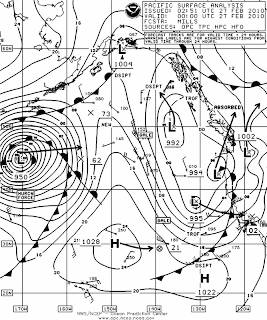
 On the 26th, this North Pacific storm hit 950 mb, and by the 27th, it was one of the best I've ever seen:
 On February 26th-28th windstorm Xynthia hit western Europe causing major damage and killing 63. The storm bottomed out at 967 mb, and produced winds up to 150 mph in France, where it was described as the worst storm since 1999.

No comments:
Post a Comment