Dec 29, 2010

Western Winter Storm and Florida Cold

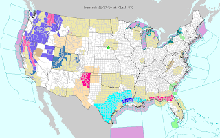
A large winter storm has most of the western US under winter storm (pink) and blizzard warnings (red).Southeast Arizona including the Tucson area is under hard freeze (dark blue) and winter storm warnings. Higher elevations - even right down to the Mexican border - are under blizzard warnings incuding Bisbee. A gale warning is active for the entire West Coast.

Low temperatures on the morning of December 28th in Florida included 24 at Daytona Beach, 27 at Sarasota, 32 at Tampa, 34 at West Palm Beach, 39 at Miami, 44 at Marathon, and 49 at Key West.

Dec 27, 2010

Winter Weather for East Coast/Europe/Australia

A monster 961 mb blizzard hit the East Coast today and yesterday.
Yesterday afternoon, blizzard warnings (red) were in effect along the coast from Maine to New Jersey, with winter storm (pink) and storm warnings (purple) going down to South Carolina.
Up to 32" of snow fell in New Jersey (Rahway) and winds gusted to 80 mph on Cape Cod (Wellfleet). As much as 29" fell on Staten Island (Great Kills), and 24.5" on Long Island (Marine Park) with JFK Airport receiving 15.5", Upton 18.8", and Central Park 20".

The heavy snow and high winds crippled travel and knocked out power across the northeast. In New York City, buses were stranded, and a subway train and its passengers were stuck in the snow for hours.

Marine life is being threatened by the low temperatures even down to South Carolina.

Columbia, SC had the first significant Christmas snow since records began in 1887, and the Atlanta area had the first measurable snow on Christmas since 1881.

This storm has pushed arctic air into southern Florida.
850 mb temps from this morning's soundings were -3C at Cape Canaveral, -4C at Tampa, 0C at Miami, and 2C at Key West. Hard freeze warnings (dark blue) have again been issued for southern Florida:On December 21st, this huge storm (964 mb on December 23 0Z) missed most of the East Coast:The Gulf Stream, which normally allows storms to form closer to the coast, has been flowing farther east than normal:
At buoy 41025 near Cape Hatteras, the water temperature was only 47F during this storm. What is interesting about today's East Coast blizzard is that it happened despite a water temperature at the same buoy currently at only 43F.

The harsh winter continues to affect Europe, from Germany to Britain and France. In Britain, where December is expected to be the coldest in 100 years, flights and trains were canceled because of more heavy snow. In Paris, flights were canceled at Charles De Gaulle Airport because of a shortage of antifreeze, and part of the airport was evacuated because fears of a roof collapse under the weight of a foot of snow. Even Australia had 30 cm of snow in New South Wales during their summer. The storm can be seen on these charts from December 19th:
Some are even saying that the cold and snow is because of global warming.

Dec 16, 2010

Greenland High at 1078 mb

On yesterday's (December 15th) 18Z (12:00PM CST) surface analysis chart from the Ocean Prediction Center, the Greenland high was at an incredible 1078 mb:
A GFS analysis chart from the same time shows the enormous upper ridge over the northwest Atlantic and the strong convergent flow across central Greenland:

Second Round of Record Cold in Florida

An arctic outbreak put the 540 line near Tampa, FL on the morning of December 13th:
At 850 mb, temperatures as cold as -8C were pushing into northern Florida as the freezeing line hovered near Lake Okeechobee.
Hard freeze warnings (dark blue) went down to southern Florida on Tuesday night (14th).
Here are some of the morning lows/afternoon highs (not 24-hour max/min) and new records from along the Gulf Coast and Florida for December 13th, 14th, 15th:

Lakefront Airport, New Orleans, LA: 13th: 36/46, 14th: 33/48

New Orleans Naval Air Station, Belle Chasse, LA: 13th: 34/45, 14th: 27/50

Gulfport, MS: 13th: 32/47, 14th: 26/45

Baton Rouge, LA: 13th: 30/46, 14th: 26/52

Mobile Regional Airport, AL: 13th: 29/43, 14th: 24 (old record 26 set in 1962)/49

Mobile Downtown Airport, AL: 13th: 29/43, 14th: 24/46

Tyndall Air Force Base, Panama City, FL: 13th: 32/42, 14th: 26/47, 15th: 27/57

Northwest Florida Beaches International Airport, Panama City, FL: 13th: 31/42, 14th: 23/48, 15th: 25/55

Apalachicola, FL: 13th: 32/44, 14th: 26 (old record 27 set in 1996)/49, 15th: 27 (old record 29 set in 1968)/55

Tallahassee Regional Airport, FL: 13th: 32/43, 14th: 25/46, 15th: 21/50

Perry-Foley Airport, Perry, FL: 13th: 33/45, 14th: 20/47, 15th: 23/52

Cross City Airport, FL: 13th: 33/46, 14th: 22/49, 15th: 19/57

Jacksonville International Airport, FL: 13th: 31/45, 14th: 20 (old record 24 set in 1960)/45, 15th: 21 (old record 25 set in 1962)/54

Gainesville Regional Airport, FL: 13th: 34/46, 14th: 23/48, 15th: 22 (old record 26 set in 1989)/57

Daytona Beach International Airport, FL: 13th: 35/46, 14th: 24/48 (old record 52 set in 1962), 15th: 26 (old record 29 set in 1962)/56

Orlando Executive Airport: 13th: 39/48, 14th: 28/49 (old record 541962), 15th: 31/56

Orlando International Airport: 13th: 40/49, 14th: 28/49, 15th: 31(old record 33 set in 1968)/57

Vero Beach Municipal Airport, FL: 13th: 38/56, 14th: 26/53 (old record 56 set in 1962), 15th: 29 (old record 35 set in 1962)/58

Tampa International Airport: 13th: 44/50, 14th: 32/48, 15th: 34/56

Charlotte County Airport, Punta Gorda, 13th: 48/58, 14th: 31/53, 15th: 29/59

Page Field, Fort Myers, FL: 13th: 50/60, 14th: 34/54, 15th: 33 (ties record from 1944)/60

Naples Municipal Airport, FL: 13th: 56/63, 14th: 37/52 (old record 59 set in 1982), 15th: 36/58 (old record 60 set in 2002)

Palm Beach International Airport, West Palm Beach, FL: 13th: 48/60, 14th: 32 (old record 33 set in 1962)/55 (old record 58 set in 1962), 15th: 35/63

Hollywood International Airport, Fort Lauderdale, FL: 14th: 34 (tied record from 1962)/53 (old record 63 set in 1969), 15th: 37/62

Fort Lauderdale Executive Airport: 14th: 34/54, 15th: 35/62

Miami International Airport, FL: 14th: 36 (old record 39 set in 1962)/53 (old record 59 set in 1962), 15th: 36 (old record 42 set in 1942)/62 (ties record from 1968)

Homestead Air Force Base, FL: 14th: 35/53, 15th: 43/62

Marathon Airport, FL: 14th: 44/51, 15th: 45/54

Key West Airport: 14th: 50 (ties record from 1962)/54, 15th: 46 (old record 52 set in 1885)/57 old record 60 set in 1962)

On the 13th, dewpoints were as low as 4 at New Otleans Naval Air Station and 0 at Gulfport; on the 14th, dewpoints were 1 at Mobile Regional Airport, -3 at Tallahassee, 3 at Apalachicola, -2 at Perry, -2 at Gainesville, -2 at Orlando Executive, 0 at Tampa, and 18 at Marathon; on the 15th -2 at Daytona Beach, -2 at Vero Beach, 10 at Naples, 0 at West Palm Beach, 4 at Miami, and 31 at Key West. As is often the case, these low dewpoints occurred in the afternoon when drier air aloft can more easily mix down to the surface.

Dec 13, 2010

Hard Freeze in Southern Florida Tonight

Most of Florida is under a hard freeze warning tonight including Tampa, Sarasota, areas adjacent to Lake Okeechobee, West Palm Beach, and Boca Raton. The rest of mainland Florida is under a freeze warning including Miami. A wind chill warning is in effect for all of central and southern Florida. Gale warnings are in effect down to the Florida Keys.

12Z GFS MOS minimum temperatures for tomorrow morning are 15 at Perry, 15 at Gainesville, 16 at Jacksonville, 19 at St Augustine, 23 at Daytona Beach, 23 at Orlando International, 27 at Tampa, 34 at Miami, 43 at Marathon, and 52 at Key West.

International Falls, MN hit -33F this morning.

Dec 12, 2010

Major Midwest Blizzard Underway


A large winter storm has hit the Midwest with 26" of snow (Winona, MN) and wind gusts up to 62 mph (Grand Island, NE). At Rochester, MN, 15" of snow broke the record of 5.5" set in 1893 for December 11th, and the record for daily snowfall for December. The old record was 10.3" on December 25th, 1955. The snow even collapsed the Minneapolis Metrodome. The storm total reported at Minneapolis/St Paul international Airport was 17.1".

Last night, blizzard warnings (red) went from Nebraska and South Dakota to Michigan:
Winter storm warnings are in pink, winter weather advisories in purple, and wind chill advisories in light blue. Because of arctic air surging southward behind this storm, the current map again has hard freeze warnings (dark blue) along the Gulf Coast, freeze warnings (light blue) for southern Texas and New Orleans, wind chill advisories for central Florida, and wind chill watches for southern Florida.
In Florida, 6Z GFS MOS has low temperatures for Tuesday morning at 18 for Gainesville, 24 for Daytona Beach, 37 for Miami, and 53 for Key West.

Dec 9, 2010

Winter Weather in North America and Europe

Freezing fog was reported this morning in northern Louisiana including at Alexandria:

It was thick and persistent enough that a freezing fog advisory was issued.

On the morning of December 7th, International Falls hit -19F.

The low temperature of 50F at Cancun yesterday morning (December 8th) was the coldest ever for the entire month of December.

In Britain, the Army was called in to help clear away snow as temperatures dropped to -15C (5F). Additionally, it was found that at the station with the longest temperature record in the world (since 1659, although daily records began in 1772) in central England, the last week in November and first week in December were the coldest ever. The Eiffel Tower was closed after Paris was hit with the heaviest one-day snow (11 cm) since 1987.

Dec 8, 2010

Record Breaking Cold in Florida

Cold air had penetrated deep into the south - crops have already been damaged even in southern Florida. Hard freeze warnings have been issued again tonight for Baton Rouge, LA; Gulfport, MS; Apalachicola, FL and Perry, FL. Freeze warnings continue for Beaumont, TX; New Orleans, LA; Jacksonville, FL and Gainesville, FL. Here are some of the morning low/afternoon high (not 24-hour max/min) temperatures that have been recorded so far for the 6th, 7th, and 8th along the Gulf Coast and Florida along with the records which were broken at official observing stations:

Lakefront Airport, New Orleans, LA: 6th: 38/49, 7th: 41/49, 8th: 43/51

New Orleans Naval Air Station, Belle Chasse, LA: 6th: 36/50, 7th: 27/54, 8th: 33/52

Gulfport, MS: 6th: 33/53, 7th: 28/54, 8th: 34/52

Baton Rouge, LA: 6th: 30/51, 7th: 25/54, 8th: 40/49

Mobile Regional Airport, AL: 6th: 29/49, 7th: 26/53, 8th: 29/46

Mobile Downtown Airport, AL: 6th: 30/50, 7th: 27/54, 8th: 31/46

Tyndall Air Force Base, Panama City, FL: 6th: 33/51, 7th: 31/51, 8th: 34/44

Northwest Florida Beaches International Airport, Panama City, FL: 6th: 29/52, 7th: 25/53, 8th: 25/42

Apalachicola, FL: 6th: 31/52, 7th: 30/52, 8th: 28/51

Tallahassee Regional Airport, FL: 6th: 27/50, 7th: 25/51, 8th: 21/46

Perry-Foley Airport, Perry, FL: 6th: 28/51, 7th: 23/53, 8th: 21/48

Cross City Airport, FL: 6th: 28/51, 7th: 28/53, 8th: 21/53

Jacksonville International Airport, FL: 6th: 28/50, 7th: 28/52, 8th: 24 (old record 28 set in 1984)/52

Gainesville Regional Airport, FL: 6th: 30/51, 7th: 29/53, 8th: 23 (old record 24 set in 1959)/55

Daytona Beach International Airport, FL: 6th: 35/53 (old record 54 set in 1962), 7th: 31/52, 8th: 29/59

Orlando Executive Airport: 6th: 38/54, 7th: 35/52, 8th: 34/58

Orlando International Airport: 6th: 38/54 (old record 56 set in 1962), 7th: 35/53, 8th: 31 (old record 33 set in 1959)/60

Vero Beach Municipal Airport, FL: 6th: 41/60, 7th: 31 (old record 38 set in 1977)/56, 8th :32 (old record 39 set in 1962)/62

Tampa International Airport: 6th: 38/54, 7th: 37/51, 8th: 36/58

Charlotte County Airport, Punta Gorda, FL: 6th: 41/58, 7th: 33/58, 8th: 32/63

Page Field, Fort Myers, FL: 6th: 44/59, 7th: 38/59, 8th: 39/64

Naples Municipal Airport, FL: 6th: 47/58 (old record 70 set in 1997), 7th: 39 (old record 41 set in 1984)/59 (old record 63 set in 1962), 8th: 39 (old record 42 set in 1984)/64 (old record 68 set in 1968)

Palm Beach International Airport, West Palm Beach, FL: 6th: 46/63 (old record 64 set in 1945), 7th: 36/59 (old record 63 set in 1984), 8th: 37 (old record 43 set in 1937)/67

Hollywood International Airport, Fort Lauderdale, FL: 6th: 49/61 (old record 68 set in 2003), 7th: 40 (old record 42 set in 1841)/58 (old record 64 set in 1997), 8th: 39 (old record 43 set in 1959)/67 (old record 69 set in 1959)

Fort Lauderdale Executive Airport: 6th: 50/62, 7th: 39/59, 8th: 38/66

Miami International Airport, FL: 6th: 51/63 (old record 65 set in 1897), 7th: 43 (old record 49 set in 2003)/61, 8th: 43 (old record 52 set in 1984)/65

Homestead Air Force Base, FL: 6th: 49/64, 7th: 40/62, 8th: 37/64

Marathon Airport, FL: 6th: 56/62, 7th: 50/60, 8th: 49/59

Key West Airport: 6th: 62/64, 7th: 57/61, 8th: 54/61 (old record 66 set in 1903)

Cancun, Mexico: 6th: 53/78, 7th: 53/75, 8th: 50/77

Cancun, where the climate conference is being held, had already hit 11C (51.8F) on the morning of Sunday, December 5th.

Additionally, dewpoints were extremely low on the 7th: 13 at New Orleans NAS (21 at Lakefront); 14 at Gainesville, FL and 22 at Tampa, FL. Today, dewpoints were very low even further south into Florida: 25 at Miami, 37 at Marathon, and 45 at Key West.

Most of western Europe continues to be affected by unusual cold and snow. A snowstorm forced the closure of Charles De Gaulle Airport in Paris and the shutting down of the Paris bus system.

Dec 7, 2010

Satellite Images of Snow Cover in Europe

On November 27th, significant snow cover can already be seen over Britain in the lower part of this Aqua satellite image:
An Aqua image from November 29th shows snow cover in Ireland, southern Britain, and the Alps all the way down to Italy.
This Aqua image from December 1st reveals extensive snow cover over the British Isles and Denmark.A Terra image from December 2nd has a good view of Ireland:Aqua image from December 3rd clearly showing snow on both sides of the English channel:
Aqua from December 4th showing Ireland almost completely snow covered:

Hard Freeze in Florida

Hard freeze warnings (dark blue) have been issued as far south as Apalachicola, FL; Gainesville, FL; Ocala, FL; Gulfport, MS; and Baton Rouge, LA. Freeze warnings (light blue) are in effect along the Gulf Coast from Beaumont, TX to New Orleans, and in Florida, include the cities Fort Myers, West Palm Beach, and Boca Raton. A wind chill advisory has been issued for the rest of southern Florida except the Keys.

Dec 4, 2010

Record Cold for Florida Possible

Today's Midwest snowstorm will push a cold front through all of Florida tomorrow night. It will then consolidate into a large nor'easter on Monday, and force even colder air into Florida. Today's 21Z SREF has the 850 mb 0C isotherm running from Fort Myers to Palm Bay by 18Z Tuesday, and the 4C isotherm approaching the Keys.
GFSX MOS minimum temps for Wednesday morning are 23 at Gainesville (record for the date is 28), and 53 at Key West (record 55).

Dec 3, 2010

Winter Off to Early Start in US and Europe

Winter conditions are already becoming widespread across the contiguous US.
Winter weather advisories (purple) stretch from North Dakota to North Carolina. Parts of northern Florida are under a freeze warning (light blue) for the third straight day. Gainesville, FL had a low temperature this morning of 28, and yesterday morning (Dec 2nd) of 27. This morning at Baudette, MN, the low temperature was -17.

In Europe, at least 60 people were killed from cold. Temperatures were as cold as -15C (5F) in Poland, -20C (-4) at Braemar, Scotland, -24C (-11F) at Moscow, and -51C (-60F) in Siberia. London's Gatwick airport was shut down for two days because of snow, and now flights are expected to be limited by freezing fog.

Nov 30, 2010

Cold Front Hits Southern Mexico


At 3:00PM today, a cold front extends from a 992 mb low near Thunder Bay, Ontario, to southern Mexico. At Veracruz, the wind went from calm at 9:44AM CST (15:44Z) to 40 knots with gusts to 50 knots at 12:43PM (18:43Z). Blowing sand was also reported. Currently (4:50 CST, 22:50Z) at buoy 42055 in the Bay of Campeche, winds are 36.9 knots, gusting to 42.7, with 11.5 foot waves.

This morning's low temperature at Tucson was 23. This breaks the old record of 24 set in 1934. In the higher elevations south and east of Tucson, three all-time November record lows were set: 11 at Bisbee-Douglas Airport, 10 at Benson 6 SE, and 14 at Safford ag station.

Nov 29, 2010

Tucson Under Hard Freeze Warning

Parts of southern Arizona including Tucson are under a hard freeze warning tonight. Currently at Tucson, the temperature is 48 and the dewpoint is 7.

On November 27th, Corpus Christi had a morning low of 31 and the arctic oscillation hit -4.

Nov 26, 2010

Corpus Christi Under Freeze Warning Tonight

Freeze warnings (light blue) have been issued for most of southern Texas tonight, including Corpus Christi.
Last night's low temperatures were 30 at Tucson, 30 at Las Vegas, 37 at San Francisco, a record tying 35 at Oakland International, and a record breaking 39 at Oakland.

Nov 25, 2010

Deep South Freeze

Freeze warnings (light blue) are active for San Antonio, Del Rio, and Eagle Pass in Texas, Phoenix and Tucson in Arizona, and Las Vegas in Nevada. Frost advisories are also active for the suburbs of San Francisco and Los Angeles.

Greenland High at 1060 mb

Yesterday, on the 0Z (6:00PM CST) surface analysis chart from the Ocean Prediction Center, the high over Greenland was at 1060 mb (3130 inches):The arctic oscillation is now approaching -3. Both suggest a high potential for deep penetration of polar air masses into the lower latitudes.

Nov 16, 2010

Minnesota and Iowa Snow

A snowstorm hit northern Iowa and southern Minnesota with over a foot of snow on November 13th. 14" was reported from Emmetsburg, IA, and 12" from Maple Grove, MN which is just northwest of Minneapolis. The official at Minneapolis/St. Paul International Airport was 8". More info here.

Nov 6, 2010

Freeze For Southeast Tonight

A Canadian airmass is spreading across the southeast tonight:
In Florida, Tallahassee, Jacksonville, and Gainesville are all under freeze warnings.
The current dewpoint in Miami is 34.

Oct 31, 2010

Tropical Storm Shary and Midwest Storm

On October 28th, at 9PM, (3Z, 29th) this area of convection just south of Bermuda was named Tropical Storm Shary.
It was in a strongly sheared environment on the northeast edge of a large closed upper low. Upper level winds were strong enough to push clouds to the Bahamas:
The large tropical wave which later became Tomas can be seen east of the Lesser Antilles and Venezuela. GFS analysis shows that the area in which Shary is located had 250 mb wind speeds in the 30-40 knot range:
The surface low is well southeast of the convection, and the strongest winds are due to a tight pressure gradient with the subtropical ridge to the north:
The 955.2 mb Midwest storm from October 26th was not the record for the lowest pressure in a non-tropical storm in the Continental U.S. A reading of 955.0 was confirmed at Block Island, RI on March 7th, 1932 and at Canton, NY on January 3rd, 1913. The October 26th storm is still the record for any Midwest storm.

A storm near the Aleutians bottomed out at 939 mb last night:
Buoy 46205 west of British Columbia just (as of 0Z) reported 48.6 knot winds with gusts to 64.1, and 34.1 foot waves.

Oct 27, 2010

Midwest Storm Drops to 955 mb

At 5:13 PM on October 26th the pressure reported from Bigfork, MN was 955.2 mb (28.21 inches). This set a new record for the lowest pressure in a non-tropical storm in the Continental U.S. New low pressure records were also set at Duluth, International Falls, the state of Wisconsin, and La Crosse. More here.

This storm dumped 8.5" of snow in North Dakota, and 8" in northeast Minnesota, including a record 7.7" at Duluth. Winds gusted to 70 mph or greater in North Dakota (70),South Dakota (75), Wisconsin (76), Illinois (70), Michigan (78 on Mackinac Bridge), and Indiana (77). Water vapor imagery reveals the scale of this storm.Lubbock, TX is now under frost advisory, and Roswell, NM a hard freeze warning.