Nov 27, 2014

Thanksgiving Snowstorm

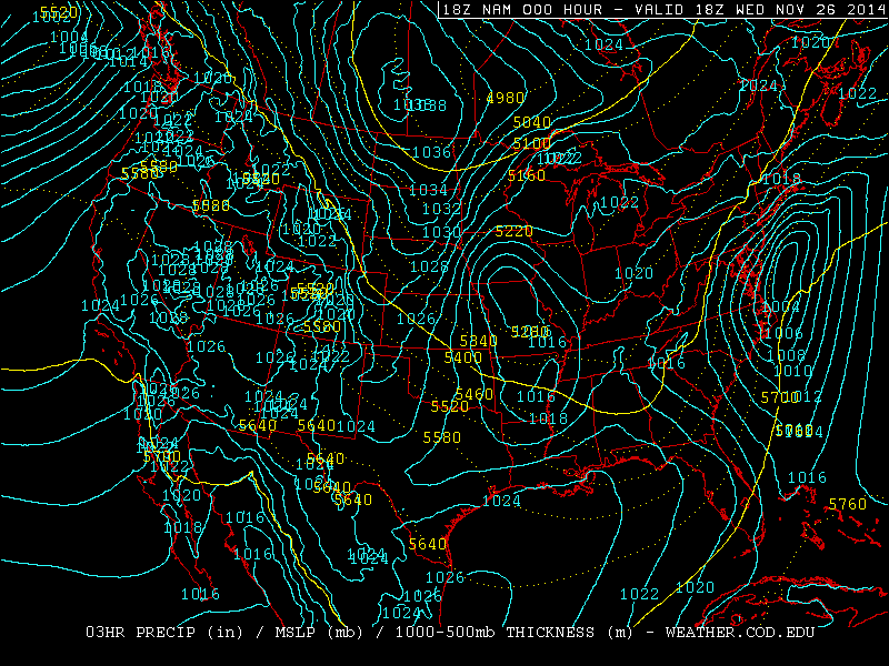
Yesterday (Nov 26, day before Thanksgiving), a Nor'Easter hit Massachusetts with 15" of snow (Savoy) and West Virginia with 20" (Paw Paw). One interesting feature of this storm was that because of an isothermal layer from 700-550 mb seen in the Albany, NY sounding, heavy snow fell over 100 miles south of the 540 line.


With temperatures at or above -10C up to the 550 mb level, heavy wet snow fell and caused over 350,000 power outages.

This storm pushed polar air deep into the Gulf of Mexico. At station 42002, 207 nautical miles east of Brownsville, TX the dew point dropped into the mid 30s:

Nov 26, 2014

Siberian Cold

Temperatures in Siberia have already dropped to -61 F (-52 C). A Russian plane that was stuck because the wheels were frozen to the ground was pushed by the passengers. 850 temps are well below normal in Siberia for this time of year:
For comparison, here is the same chart from the same time last year:

Nov 25, 2014

Record Cold And Snow In Chicago

From November 12th to the 18th, there were 180 consecutive hours below freezing - a new record for November. The old record was 172 hours November 24th to 30th in 1903. There were eight consecutive days with at least a trace of snow From November 12th to 18th. This is the earliest this has been recorded for Chicago. The old record was from November 13 to 20th 1937.

Nov 21, 2014

Buffalo Snow

Snow began falling in Upstate New York on Monday, Nov 17, and ended tonight. The highest total was 88" from Cowlesville (about 15 miles east of Buffalo). Second highest was 79.5" in Hamburg (8 miles south of Buffalo). See pictures here. It has been reported that 30 roofs have collapsed under the weight of the snow.

Nov 19, 2014

Record Cold In Florida

Low temperatures from this morning include:
31 at New Orleans
23 at Mobile
25 at Pensacola (new record, old record 28 in 1903)
22 at Tallahassee (new record, old record 25 in 2008)
27 at Jacksonville (new record, old record 28 in 2008)
41 at Tampa

Nov 18, 2014

Hard Freeze Warning In Florida

A hard freeze warning is in effect for tonight for most of northern Florida, including Ocala. Orlando is under a wind chill advisory (light blue):
Yesterday morning's (Nov 17) lows included 23 at Dallas and 37 at Corpus Christi. This morning it was 24 in Atlanta and 27 at Mobile Regional Airport. This air mass is moving into Florida now:

Nov 17, 2014

Near Record Low Tornado Numbers

For the third consecutive year, the number of tornadoes reported in the US is near or at record lows. The min/max lines are based on data from 1954-2007.


Here are the last 10 years on the same chart. All three of the last years are clustered at the bottom.

Nov 14, 2014

Gulf Coast Freeze

This morning, Nov 14, the low temperature at downtown Mobile and Pensacola was 32. Similar temps are expected again tonight. All models indicate that the next surge of arctic air on Tuesday will be even colder.

Jordan, MT had a low of -26 this morning. Casper, WY was -27 the night of Nov 14.

Nov 9, 2014

Bering Sea Storm Update

Aqua/MODIS image of the Bering Sea at 00:35Z Nov 9

The Bering Sea storm produced 31.2 foot waves at station 46072 on Nov 8 at 3:50 PM AKST. 44.7 knot wind gusts were reported at 6:50 AM on Nov 9 from the same station.

Nov 8, 2014

Bering Sea Storm

Aqua/MODIS image of the western Bering Sea at 1:30Z Nov 8

Super Typhoon Nuri was absorbed into an extratropical storm two days ago. Last night (at 6Z), it reached a minimum pressure of 924 mb as it entered the Bering Sea:
This storm went from 964 mb at 12Z Nov 7, to 927 mb at  0Z Nov 8 - an incredible 37 mb drop in just 12 hours. Although buoy data is sparse, station 46035 in the central Bering Sea reported a 44.7 knot wind gust and 26.6 foot waves. Here is the latest satellite imagery:


Nov 1, 2014

Halloween Storm

Yesterday, accumulating snow fell from the Great Lakes to the Southern Appalachians:
A 69 mph wind gust was measured at Gary Airport in Indiana. The South Lake Michigan Buoy recorded a 51 knot (59mph) gust, which is the second highest since 1981. It also reported a tie for the second highest wave height - 21.7 feet.

This morning (Nov 1), freezing temperatures occurred across Oklahoma, Arkansas, and Northern Mississippi. Tonight, the freeze may reach the Florida Panhandle: